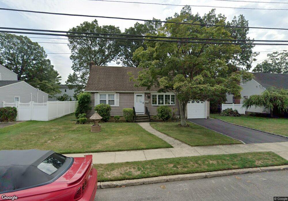
132 Commonwealth Ave Massapequa, NY 11758
Estimated Value: $645,663 - $712,000
--
Bed
2
Baths
1,275
Sq Ft
$532/Sq Ft
Est. Value
About This Home
This home is located at 132 Commonwealth Ave, Massapequa, NY 11758 and is currently estimated at $678,832, approximately $532 per square foot. 132 Commonwealth Ave is a home located in Nassau County with nearby schools including Massapequa High School - Ames Campus, Berner Middle School, and Massapequa High School.
Ownership History
Date
Name
Owned For
Owner Type
Purchase Details
Closed on
Mar 19, 2013
Sold by
Upton Mary R and Kelly John T
Bought by
Upton Mary R and Kelly John T
Current Estimated Value
Home Financials for this Owner
Home Financials are based on the most recent Mortgage that was taken out on this home.
Original Mortgage
$212,000
Outstanding Balance
$149,874
Interest Rate
3.58%
Estimated Equity
$528,958
Purchase Details
Closed on
Nov 18, 2004
Sold by
Kelly Therese
Create a Home Valuation Report for This Property
The Home Valuation Report is an in-depth analysis detailing your home's value as well as a comparison with similar homes in the area
Home Values in the Area
Average Home Value in this Area
Purchase History
| Date | Buyer | Sale Price | Title Company |
|---|---|---|---|
| Upton Mary R | -- | -- | |
| -- | -- | -- |
Source: Public Records
Mortgage History
| Date | Status | Borrower | Loan Amount |
|---|---|---|---|
| Open | Upton Mary R | $212,000 |
Source: Public Records
Tax History Compared to Growth
Tax History
| Year | Tax Paid | Tax Assessment Tax Assessment Total Assessment is a certain percentage of the fair market value that is determined by local assessors to be the total taxable value of land and additions on the property. | Land | Improvement |
|---|---|---|---|---|
| 2025 | $12,451 | $437 | $191 | $246 |
| 2024 | $3,660 | $437 | $191 | $246 |
| 2023 | $11,535 | $451 | $197 | $254 |
| 2022 | $11,535 | $458 | $200 | $258 |
| 2021 | $11,204 | $477 | $208 | $269 |
| 2020 | $11,775 | $640 | $639 | $1 |
| 2019 | $11,335 | $640 | $639 | $1 |
| 2018 | $10,536 | $640 | $0 | $0 |
| 2017 | $6,599 | $680 | $534 | $146 |
| 2016 | $9,906 | $720 | $566 | $154 |
| 2015 | $3,728 | $854 | $671 | $183 |
| 2014 | $3,728 | $854 | $671 | $183 |
| 2013 | $3,926 | $854 | $671 | $183 |
Source: Public Records
Map
Nearby Homes
- 128 Massachusetts Ave
- 102 Boston Ave
- 121 Ontario Ave
- 163 Massachusetts Ave
- 73 Massachusetts Ave
- 86 Cleveland Ave
- 101 Toronto Ave
- 70 Pittsburgh Ave
- 136 Euclid Ave
- 76 Hamilton Ave
- 73 Chicago Ave
- 20 Boston Ave
- 254 N Richmond Ave
- 116 Parkhill Ave
- 104 Clark Ave
- 203 N Manhattan Ave
- 11 Pittsburgh Ave
- 22 Commonwealth Ave
- 598 N Suffolk Ave
- 51 Michigan Ave
- 134 Commonwealth Ave
- 130 Commonwealth Ave
- 131 Massachusetts Ave
- 127 Massachusetts Ave
- 131 Massachusetts Ave
- 133 Massachusetts Ave
- 125 Massachusetts Ave
- 131 Commonwealth Ave
- 653 Franklin Ave
- 122 Commonwealth Ave
- 123 Massachusetts Ave
- 129 Commonwealth Ave
- 133 Commonwealth Ave Unit A
- 645 Franklin Ave
- 118 Commonwealth Ave
- 135 Commonwealth Ave
- 127 Commonwealth Ave
- 119 Massachusetts Ave
- 118 Rhode Island Ave
- 132 Massachusetts Ave