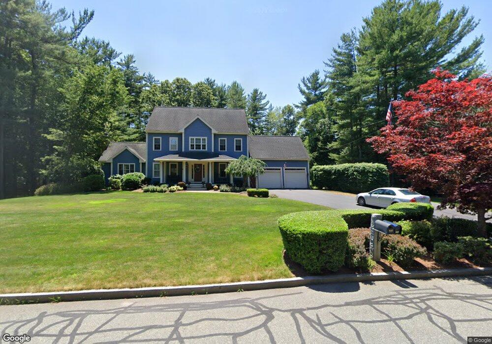
132 Katherines Way Raynham, MA 02767
Estimated Value: $858,050 - $1,171,000
--
Bed
3
Baths
2,932
Sq Ft
$330/Sq Ft
Est. Value
About This Home
This home is located at 132 Katherines Way, Raynham, MA 02767 and is currently estimated at $968,013, approximately $330 per square foot. 132 Katherines Way is a home located in Bristol County with nearby schools including LaLiberte Elementary School, Merrill Elementary School, and Williams Intermediate School.
Ownership History
Date
Name
Owned For
Owner Type
Purchase Details
Closed on
Mar 21, 2003
Sold by
Perk Rt
Bought by
Tonderys Peter J and Tonderys Alisa B
Current Estimated Value
Home Financials for this Owner
Home Financials are based on the most recent Mortgage that was taken out on this home.
Original Mortgage
$155,000
Outstanding Balance
$66,732
Interest Rate
5.9%
Mortgage Type
Purchase Money Mortgage
Estimated Equity
$901,281
Create a Home Valuation Report for This Property
The Home Valuation Report is an in-depth analysis detailing your home's value as well as a comparison with similar homes in the area
Home Values in the Area
Average Home Value in this Area
Purchase History
| Date | Buyer | Sale Price | Title Company |
|---|---|---|---|
| Tonderys Peter J | $465,000 | -- |
Source: Public Records
Mortgage History
| Date | Status | Borrower | Loan Amount |
|---|---|---|---|
| Open | Tonderys Peter J | $155,000 |
Source: Public Records
Tax History Compared to Growth
Tax History
| Year | Tax Paid | Tax Assessment Tax Assessment Total Assessment is a certain percentage of the fair market value that is determined by local assessors to be the total taxable value of land and additions on the property. | Land | Improvement |
|---|---|---|---|---|
| 2025 | $9,849 | $814,000 | $220,900 | $593,100 |
| 2024 | $9,732 | $783,600 | $220,900 | $562,700 |
| 2023 | $9,128 | $671,200 | $198,800 | $472,400 |
| 2022 | $8,772 | $591,500 | $180,800 | $410,700 |
| 2021 | $8,660 | $589,500 | $178,800 | $410,700 |
| 2020 | $8,408 | $583,500 | $172,800 | $410,700 |
| 2019 | $8,303 | $583,500 | $172,800 | $410,700 |
| 2018 | $8,080 | $542,300 | $168,800 | $373,500 |
| 2017 | $7,843 | $521,800 | $160,800 | $361,000 |
| 2016 | $7,739 | $516,600 | $155,600 | $361,000 |
| 2015 | $7,509 | $492,700 | $154,500 | $338,200 |
Source: Public Records
Map
Nearby Homes
- 1037 N Main St
- 970 N Main St
- 643 Center St
- 21 Sully Rd
- 73 Sherwood Ln
- 2 Maplewood Ln Unit 21-1
- 0 Maplewood Unit 21.3 73426136
- 0 Maplewood Unit 33-1 73420094
- 100 Francine Rd
- 25 Twin Diamond Dr
- 40 Country Club Dr
- 115 Goldfinch Dr
- 520 King St
- 100 Pleasant St
- 53 Queens Cir
- 1570 Old Pleasant St
- 92 N Main St
- 29 Saddle Dr
- 930 King St
- 120 King St
- 183 Ramblewood Dr
- 195 Ramblewood Dr
- 156 Katherines Way
- 108 Katherines Way
- 171 Ramblewood Dr
- 127 Katherines Way
- 209 Ramblewood Dr
- 111 Katherines Way
- 147 Katherines Way
- 159 Ramblewood Dr
- 68 Anthony Rd
- 219 Ramblewood Dr
- 91 Katherines Way
- 88 Katherines Way
- 164 Ramblewood Dr
- 167 Katherines Way
- 168 Katherines Way
- 232 Ramblewood Dr
- 145 Ramblewood Dr
- 167 Katherine's Way