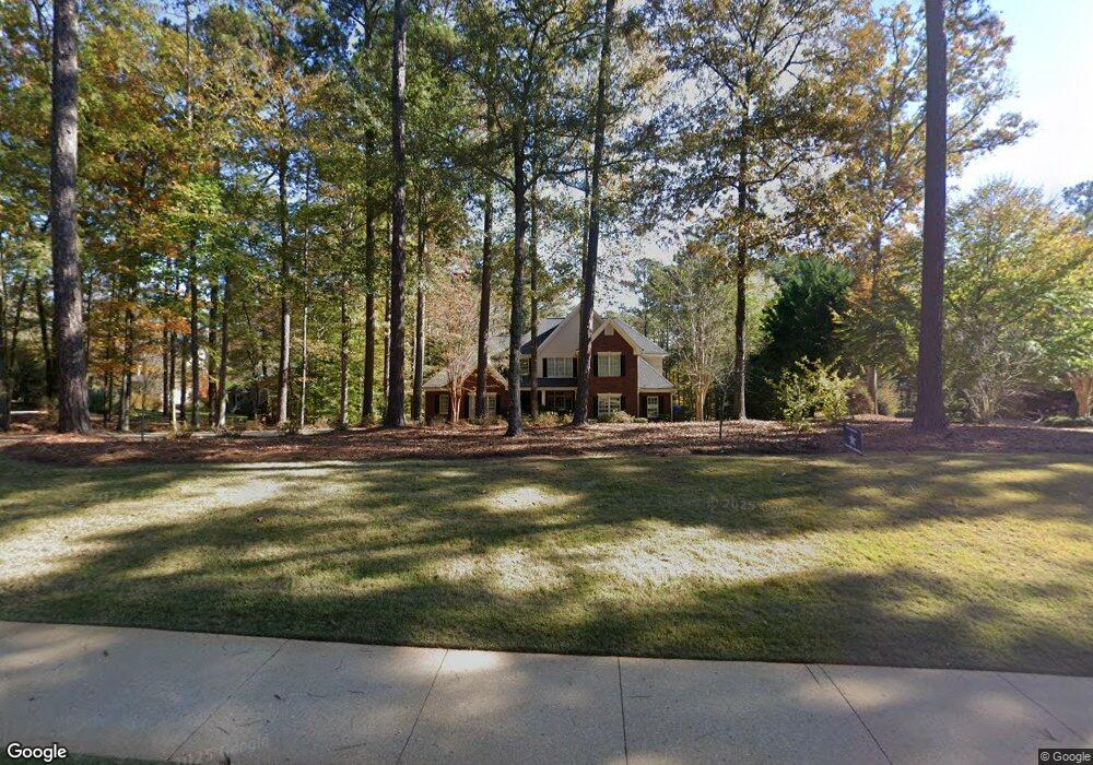
132 Morgan Dr Lagrange, GA 30240
Estimated Value: $888,051 - $1,153,000
5
Beds
5
Baths
5,158
Sq Ft
$194/Sq Ft
Est. Value
About This Home
This home is located at 132 Morgan Dr, Lagrange, GA 30240 and is currently estimated at $1,002,513, approximately $194 per square foot. 132 Morgan Dr is a home located in Troup County with nearby schools including Hollis Hand Elementary School, Ethel W. Kight Elementary School, and Franklin Forest Elementary School.
Ownership History
Date
Name
Owned For
Owner Type
Purchase Details
Closed on
Oct 1, 2020
Sold by
Myers Michael Denson
Bought by
Wilson Jeff and Wilson Carmen
Current Estimated Value
Purchase Details
Closed on
Aug 2, 2010
Sold by
Hale Natalie K
Bought by
Myers Michael Denson
Home Financials for this Owner
Home Financials are based on the most recent Mortgage that was taken out on this home.
Original Mortgage
$674,250
Interest Rate
4.61%
Mortgage Type
New Conventional
Purchase Details
Closed on
Jun 28, 2004
Sold by
Riggs & Barintine Dev
Bought by
Hale Natalie K
Create a Home Valuation Report for This Property
The Home Valuation Report is an in-depth analysis detailing your home's value as well as a comparison with similar homes in the area
Purchase History
| Date | Buyer | Sale Price | Title Company |
|---|---|---|---|
| Wilson Jeff | $639,000 | -- | |
| Myers Michael Denson | $750,000 | -- | |
| Hale Natalie K | $125,000 | -- |
Source: Public Records
Mortgage History
| Date | Status | Borrower | Loan Amount |
|---|---|---|---|
| Previous Owner | Myers Michael Denson | $674,250 |
Source: Public Records
Tax History
| Year | Tax Paid | Tax Assessment Tax Assessment Total Assessment is a certain percentage of the fair market value that is determined by local assessors to be the total taxable value of land and additions on the property. | Land | Improvement |
|---|---|---|---|---|
| 2025 | $9,999 | $371,560 | $60,000 | $311,560 |
| 2024 | $9,853 | $363,280 | $60,000 | $303,280 |
| 2023 | $7,210 | $284,240 | $60,000 | $224,240 |
| 2022 | $7,528 | $271,720 | $60,000 | $211,720 |
| 2021 | $7,709 | $323,880 | $60,000 | $263,880 |
| 2020 | $9,768 | $323,880 | $60,000 | $263,880 |
| 2019 | $8,874 | $294,240 | $60,000 | $234,240 |
| 2018 | $8,874 | $294,240 | $60,000 | $234,240 |
| 2017 | $8,874 | $294,240 | $60,000 | $234,240 |
| 2016 | $8,875 | $294,256 | $60,000 | $234,256 |
| 2015 | $8,889 | $294,256 | $60,000 | $234,256 |
| 2014 | $8,550 | $282,543 | $60,000 | $222,543 |
| 2013 | -- | $269,916 | $60,000 | $209,916 |
Source: Public Records
Map
Nearby Homes
- 2010 Foxcroft Dr
- 2005 Foxcroft Dr
- 638 Cameron Mill Rd
- 1000 Foxcroft Dr
- 960 Cameron Mill Rd
- 116 Deal Dr
- 217 Baywood Cir
- 101 Deal Dr
- 201 Willowcrest Way
- 106 Highland Park
- 107 Cameron Pointe Dr
- 102 Cameron Pointe Dr
- 104 Spring Valley Dr
- 203 Shawnee Dr
- 117 Brookwood Dr
- 112 Brookwood Dr
- 110 Pond View Point
- 210 Pinehaven Dr
- 300 Willow Pointe Dr
- 302 Willow Pointe Dr
- 130 Morgan Dr
- 134 Morgan Dr
- 134 Morgan Dr Unit 5
- 136 Morgan Dr
- 128 Morgan Dr
- 137 Morgan Dr
- 138 Morgan Dr
- 131 Morgan Dr Unit 15
- 131 Morgan Dr
- 135 Morgan Dr
- 140 Morgan Dr
- 133 Morgan Dr Unit 14
- 133 Morgan Dr
- 126 Morgan Dr
- 125 Morgan Dr
- 139 Morgan Dr
- 307 Victoria Pointe
- 124 Morgan Dr Unit 38
- 124 Morgan Dr
- 142 Morgan Dr
Your Personal Tour Guide
Ask me questions while you tour the home.