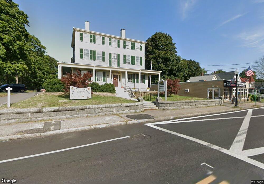
132 N Main St Middleboro, MA 02346
Estimated Value: $552,000 - $742,000
3
Beds
7
Baths
6,068
Sq Ft
$107/Sq Ft
Est. Value
About This Home
This home is located at 132 N Main St, Middleboro, MA 02346 and is currently estimated at $652,240, approximately $107 per square foot. 132 N Main St is a home located in Plymouth County with nearby schools including Mary K. Goode Elementary School and Mullein Hill Christian Academy.
Ownership History
Date
Name
Owned For
Owner Type
Purchase Details
Closed on
May 23, 2024
Sold by
Decas William C Est and Beauregart
Bought by
Friends Of The Middleboro
Current Estimated Value
Purchase Details
Closed on
May 4, 2021
Sold by
Decas Katharina C
Bought by
Decas William C
Purchase Details
Closed on
May 19, 2020
Sold by
Decas George C Est and Decas
Bought by
Decas Katharina C and Decas William C
Purchase Details
Closed on
Nov 4, 1968
Bought by
Decas George C
Create a Home Valuation Report for This Property
The Home Valuation Report is an in-depth analysis detailing your home's value as well as a comparison with similar homes in the area
Home Values in the Area
Average Home Value in this Area
Purchase History
| Date | Buyer | Sale Price | Title Company |
|---|---|---|---|
| Friends Of The Middleboro | -- | None Available | |
| Friends Of The Middleboro | -- | None Available | |
| Friends Of The Middleboro | -- | None Available | |
| Decas William C | -- | None Available | |
| Decas William C | -- | None Available | |
| Decas William C | -- | None Available | |
| Decas Katharina C | -- | None Available | |
| Decas Katharina C | -- | None Available | |
| Decas George C | -- | -- |
Source: Public Records
Tax History Compared to Growth
Tax History
| Year | Tax Paid | Tax Assessment Tax Assessment Total Assessment is a certain percentage of the fair market value that is determined by local assessors to be the total taxable value of land and additions on the property. | Land | Improvement |
|---|---|---|---|---|
| 2025 | -- | $556,900 | $144,800 | $412,100 |
| 2024 | -- | $564,700 | $144,800 | $419,900 |
| 2023 | $0 | $540,100 | $127,900 | $412,200 |
| 2022 | $0 | $528,800 | $116,600 | $412,200 |
| 2021 | $0 | $418,500 | $97,800 | $320,700 |
| 2020 | $0 | $418,500 | $97,800 | $320,700 |
| 2019 | $0 | $418,500 | $97,800 | $320,700 |
| 2018 | $0 | $435,200 | $97,800 | $337,400 |
| 2017 | $0 | $403,500 | $97,800 | $305,700 |
| 2016 | -- | $403,500 | $97,800 | $305,700 |
| 2015 | -- | $403,500 | $97,800 | $305,700 |
Source: Public Records
Map
Nearby Homes
- 6 Barrows St
- 240 N Main St
- 21 Wareham St
- 0 Wareham Miller St Unit 73410845
- 93 Peirce St
- 3 Corinne Pkwy
- 18 Rock St
- 27 Pearl St
- 66 Forest St
- 25 Hillside Ave
- LOT A Wood St
- LOT B Wood St
- 18 Leilo Dr
- 39 Riverside Dr Unit 39
- 1 Landing Way Unit 1
- 312 Wood St
- 302 Wood St
- 308 Wood St
- 48 Cross St
- 3 Old Field Way Unit 3
- 132 N Main St Unit 1
- 132 N Main St Unit 2
- 134 N Main St
- 156 N Main St
- 170 N Main St
- 21 Peirce St
- 151 N Main St
- 182 N Main St
- 4 Reland St Unit 3
- 4 Reland St Unit 1
- 6 Reland St
- 6 Reland St
- 33 Peirce St
- ooo Tanning
- 0 Off Route 79 Rhode Island Rd Unit 71480747
- 00000 Xxxxx
- xxx Xxx
- 0 Don Bouchard Way Unit 71757667
- 0 Off Cinnamon Ridge Cir Unit 71572046
- 0 Don Bouchard Way Unit 71757666