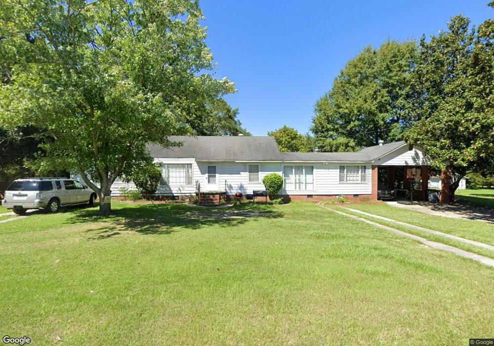
132 Poplar Cir Lagrange, GA 30241
Estimated Value: $183,000 - $200,000
4
Beds
2
Baths
1,824
Sq Ft
$104/Sq Ft
Est. Value
About This Home
This home is located at 132 Poplar Cir, Lagrange, GA 30241 and is currently estimated at $189,059, approximately $103 per square foot. 132 Poplar Cir is a home located in Troup County with nearby schools including Hollis Hand Elementary School, Franklin Forest Elementary School, and Ethel W. Kight Elementary School.
Ownership History
Date
Name
Owned For
Owner Type
Purchase Details
Closed on
Mar 10, 1999
Sold by
J R Turner Family Trust
Bought by
Glass Bridge Investment Co Lp
Current Estimated Value
Purchase Details
Closed on
Jun 30, 1998
Sold by
Turner J R
Bought by
J R Turner Family Trust
Purchase Details
Closed on
Jun 12, 1992
Sold by
Noone Dorothy Turner
Bought by
Turner J R
Purchase Details
Closed on
Aug 1, 1985
Sold by
Donna Lynn May
Bought by
Noone Dorothy Turner
Purchase Details
Closed on
Mar 1, 1985
Sold by
Virginia Edwin and Virginia Fryer
Bought by
Donna Lynn May
Purchase Details
Closed on
Nov 13, 1980
Sold by
Joe T Partain
Bought by
Virginia Edwin and Virginia Fryer
Purchase Details
Closed on
Jan 1, 1967
Sold by
Edwin G Fryer
Bought by
Joe T Partain
Create a Home Valuation Report for This Property
The Home Valuation Report is an in-depth analysis detailing your home's value as well as a comparison with similar homes in the area
Purchase History
| Date | Buyer | Sale Price | Title Company |
|---|---|---|---|
| Glass Bridge Investment Co Lp | -- | -- | |
| J R Turner Family Trust | -- | -- | |
| Turner J R | -- | -- | |
| Noone Dorothy Turner | $49,800 | -- | |
| Donna Lynn May | -- | -- | |
| Virginia Edwin | -- | -- | |
| Joe T Partain | -- | -- |
Source: Public Records
Tax History
| Year | Tax Paid | Tax Assessment Tax Assessment Total Assessment is a certain percentage of the fair market value that is determined by local assessors to be the total taxable value of land and additions on the property. | Land | Improvement |
|---|---|---|---|---|
| 2025 | $1,473 | $54,008 | $10,000 | $44,008 |
| 2024 | $1,272 | $46,648 | $10,000 | $36,648 |
| 2023 | $1,271 | $46,608 | $10,000 | $36,608 |
| 2022 | $1,178 | $42,208 | $8,000 | $34,208 |
| 2021 | $1,122 | $37,208 | $6,000 | $31,208 |
| 2020 | $1,122 | $37,208 | $6,000 | $31,208 |
| 2019 | $1,108 | $36,728 | $6,000 | $30,728 |
| 2018 | $1,011 | $33,530 | $5,550 | $27,980 |
| 2017 | $1,011 | $33,530 | $5,550 | $27,980 |
| 2016 | $1,041 | $34,528 | $5,550 | $28,978 |
| 2015 | $1,093 | $36,193 | $7,215 | $28,978 |
| 2014 | $1,053 | $34,813 | $7,215 | $27,598 |
| 2013 | -- | $35,330 | $6,772 | $28,558 |
Source: Public Records
Map
Nearby Homes
- 129 Mallory Dr
- 113 Pine Cir
- 15 Fulton St
- 2 Louise St
- 0 E Render St
- 507 Headwater Ct Unit 6
- 4 1/2 Barnard Ave
- 503 Headwater Ct Unit 4D
- 502 Headwater Ct Unit 8D
- 302 Glenhaven Dr Unit 2D
- 111 Shenandoah Ln
- 109 Shenandoah Ln
- 117 Shenandoah Ln Unit 22D
- 106 Shenandoah Ln Unit 26E
- 106 Shenandoah Ln
- 200 River Meadow Dr
- 114 Shenandoah Ln
- 141 Shenandoah Ln
- 143 Shenandoah Ln
- 147 Shenandoah Ln
Your Personal Tour Guide
Ask me questions while you tour the home.