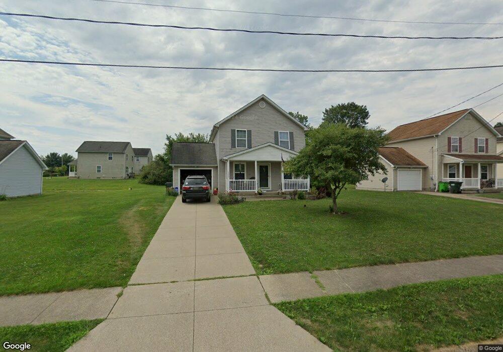
1320 Elmside St Alliance, OH 44601
Estimated Value: $169,296 - $186,000
4
Beds
2
Baths
1,440
Sq Ft
$123/Sq Ft
Est. Value
About This Home
This home is located at 1320 Elmside St, Alliance, OH 44601 and is currently estimated at $177,324, approximately $123 per square foot. 1320 Elmside St is a home located in Stark County with nearby schools including Marlington High School and Regina Coeli/St Joseph School.
Ownership History
Date
Name
Owned For
Owner Type
Purchase Details
Closed on
Sep 11, 2023
Sold by
Alliance Homes Ii Llc
Bought by
Noel Dominic
Current Estimated Value
Home Financials for this Owner
Home Financials are based on the most recent Mortgage that was taken out on this home.
Original Mortgage
$131,000
Outstanding Balance
$128,190
Interest Rate
6.9%
Mortgage Type
New Conventional
Estimated Equity
$49,134
Create a Home Valuation Report for This Property
The Home Valuation Report is an in-depth analysis detailing your home's value as well as a comparison with similar homes in the area
Home Values in the Area
Average Home Value in this Area
Purchase History
| Date | Buyer | Sale Price | Title Company |
|---|---|---|---|
| Noel Dominic | -- | None Listed On Document |
Source: Public Records
Mortgage History
| Date | Status | Borrower | Loan Amount |
|---|---|---|---|
| Open | Noel Dominic | $131,000 |
Source: Public Records
Tax History Compared to Growth
Tax History
| Year | Tax Paid | Tax Assessment Tax Assessment Total Assessment is a certain percentage of the fair market value that is determined by local assessors to be the total taxable value of land and additions on the property. | Land | Improvement |
|---|---|---|---|---|
| 2025 | -- | $44,770 | $6,340 | $38,430 |
| 2024 | -- | $44,770 | $6,340 | $38,430 |
| 2023 | $669 | $13,590 | $4,380 | $9,210 |
| 2022 | $433 | $13,590 | $4,380 | $9,210 |
| 2021 | $434 | $13,590 | $4,380 | $9,210 |
| 2020 | $471 | $13,170 | $4,240 | $8,930 |
| 2019 | $467 | $13,170 | $4,240 | $8,930 |
| 2018 | $1,092 | $25,030 | $4,240 | $20,790 |
| 2017 | $410 | $11,590 | $3,540 | $8,050 |
| 2016 | $410 | $11,590 | $3,540 | $8,050 |
| 2015 | $411 | $11,590 | $3,540 | $8,050 |
| 2014 | $433 | $11,200 | $3,430 | $7,770 |
| 2013 | $452 | $23,350 | $3,430 | $19,920 |
Source: Public Records
Map
Nearby Homes
- 0 Klinger Ave NE
- 0 Johnson Ave NE Unit 5142926
- 14422 Sturbridge Rd NE
- 0 Homestead Ave NE
- 000 Klinger Ave
- 0 Meadowbrook Ave
- 14723 Bolton St NE
- 432 Johnson Ave
- 11480 Aebi Ave NE
- 511 W Ely St
- 0 Meadow St NE
- 13334 Cindy St NE
- 329 1/2 W Main St
- 565 W Broadway St
- 345 W Market St
- 0 W Main St Unit 5090123
- 505 N Union Ave
- 124 E Wayne St
- 13109 Edison St NE
- 163 W Market St
- 1330 Elmside St
- 1240 Klinger Ave
- 1340 Elmside St
- 1315 Elmside St
- 1230 Klinger Ave
- 1325 Elmside St
- 1335 Elmside St
- 1360 Elmside St
- 1220 Klinger Ave
- 1345 Elmside St
- 1235 Shadowridge Ave NE
- 1225 Shadowridge Ave NE
- 1210 Klinger Ave
- 1365 Elmside St
- 1205 Shadowridge Ave NE
- 1375 Elmside St
- 1385 Elmside St
- 1410 Elmside St
- 1405 Elmside St
- 1160 Klinger Ave