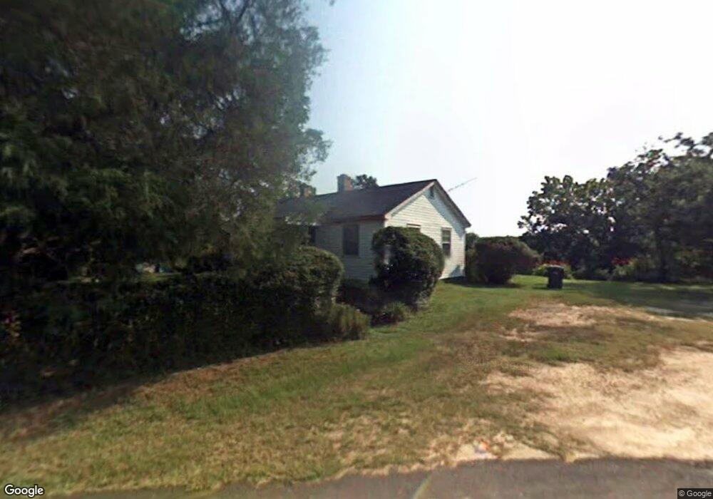
1320 Jim Adams Rd Greensboro, GA 30642
Estimated Value: $131,900 - $287,000
3
Beds
1
Bath
936
Sq Ft
$238/Sq Ft
Est. Value
About This Home
This home is located at 1320 Jim Adams Rd, Greensboro, GA 30642 and is currently estimated at $222,300, approximately $237 per square foot. 1320 Jim Adams Rd is a home located in Greene County with nearby schools including Greene County High School.
Ownership History
Date
Name
Owned For
Owner Type
Purchase Details
Closed on
Oct 25, 2019
Sold by
Wright And Wright Rental Inc
Bought by
Adams Willie E
Current Estimated Value
Purchase Details
Closed on
May 2, 2007
Sold by
Adams Willie E
Bought by
Wright & Wright Rentals Inc
Purchase Details
Closed on
Mar 15, 2001
Sold by
Adams Sammie Mae H and Adams
Bought by
Adams Rosa Etal
Purchase Details
Closed on
Jun 6, 1995
Sold by
Adams James and Adams
Bought by
Adams Sammie Mae H and Adams
Purchase Details
Closed on
Jan 1, 1977
Sold by
Adams James
Bought by
Adams James and Adams
Purchase Details
Closed on
Jan 1, 1945
Bought by
Adams James
Create a Home Valuation Report for This Property
The Home Valuation Report is an in-depth analysis detailing your home's value as well as a comparison with similar homes in the area
Home Values in the Area
Average Home Value in this Area
Purchase History
| Date | Buyer | Sale Price | Title Company |
|---|---|---|---|
| Adams Willie E | $80,000 | -- | |
| Wright & Wright Rentals Inc | $70,000 | -- | |
| Adams Rosa Etal | -- | -- | |
| Adams Sammie Mae H | -- | -- | |
| Adams James | -- | -- | |
| Adams James | -- | -- |
Source: Public Records
Tax History Compared to Growth
Tax History
| Year | Tax Paid | Tax Assessment Tax Assessment Total Assessment is a certain percentage of the fair market value that is determined by local assessors to be the total taxable value of land and additions on the property. | Land | Improvement |
|---|---|---|---|---|
| 2024 | $253 | $21,960 | $2,360 | $19,600 |
| 2023 | $243 | $20,480 | $1,800 | $18,680 |
| 2022 | $181 | $13,280 | $2,120 | $11,160 |
| 2021 | $172 | $12,120 | $2,120 | $10,000 |
| 2020 | $167 | $5,160 | $640 | $4,520 |
| 2019 | $274 | $5,160 | $640 | $4,520 |
| 2018 | $252 | $5,160 | $640 | $4,520 |
| 2017 | $245 | $5,207 | $663 | $4,544 |
| 2016 | $245 | $5,207 | $663 | $4,544 |
| 2015 | $219 | $5,206 | $663 | $4,544 |
| 2014 | $218 | $5,023 | $663 | $4,360 |
Source: Public Records
Map
Nearby Homes
- 27 acres Town Creek Blvd
- Lot 5 Town Creek Blvd
- Lot 4 Town Creek Blvd
- Lot 2 Town Creek Blvd
- Lot 1 Town Creek Blvd
- Lot 3 Town Creek Blvd
- Lot 6 Town Creek Blvd
- Lot 8 Town Creek Blvd
- Lot 7 Town Creek Blvd
- Lots 9-11 Town Creek Blvd
- 1061 Grimes St
- 1060 Stephen St
- 1801 Osprey Point
- 805 S West St
- 314 W South St
- 0 Maple Cir
- 208 W South St
- 1300 Starboard Way
- 105 Wilson St
- 2911 Carey Station Rd
- 1181 Jim Adams Rd
- 1080 Jim Adams Rd
- 1111 Jim Adams Rd
- 1410 Cedar Grove Rd
- 2330 Madison Hwy
- 1091 Jim Adams Rd
- 1081 Jim Adams Rd
- 1290 Cedar Grove Rd
- 1310 Cedar Grove Rd
- 1411 Cedar Grove Rd
- 1401 Cedar Grove Rd
- 1321 Cedar Grove Rd
- 1411 Cedar Cove Rd
- 1970 Old Eatonton Rd
- 2410 Madison Hwy
- 0 Cedar Grove Rd Unit 3266107
- 0 Cedar Grove Rd Unit 7125781
- 0 Cedar Grove Rd Unit 7225325
- 0 Cedar Grove Rd Unit 8681722
- 0 Cedar Grove Rd