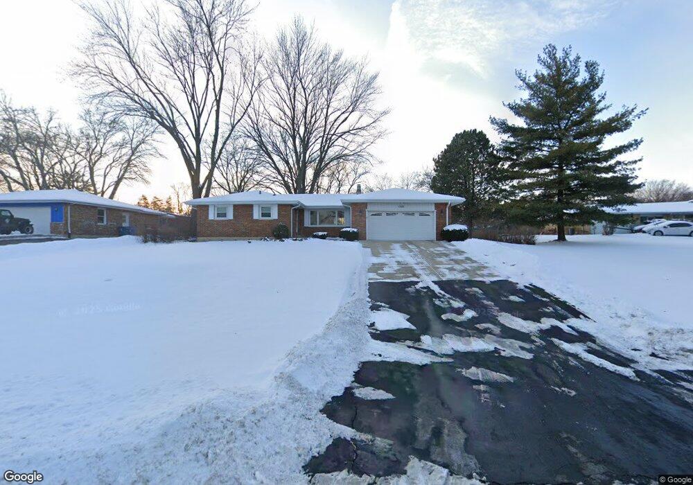
1320 Summit Dr Schaumburg, IL 60193
South Schaumburg NeighborhoodEstimated Value: $445,000 - $534,000
3
Beds
3
Baths
1,758
Sq Ft
$281/Sq Ft
Est. Value
About This Home
This home is located at 1320 Summit Dr, Schaumburg, IL 60193 and is currently estimated at $493,959, approximately $280 per square foot. 1320 Summit Dr is a home located in Cook County with nearby schools including Frederick Nerge Elementary School, Margaret Mead Junior High School, and J B Conant High School.
Ownership History
Date
Name
Owned For
Owner Type
Purchase Details
Closed on
Feb 10, 2015
Sold by
Cairns William J and Cairns Gloria
Bought by
Cairns William J and William J Cairns Jr Trust
Current Estimated Value
Purchase Details
Closed on
Oct 22, 1999
Sold by
Itasca Bank & Trust Co
Bought by
Cairns William John and Cairns Gloria
Home Financials for this Owner
Home Financials are based on the most recent Mortgage that was taken out on this home.
Original Mortgage
$115,000
Interest Rate
7.88%
Create a Home Valuation Report for This Property
The Home Valuation Report is an in-depth analysis detailing your home's value as well as a comparison with similar homes in the area
Home Values in the Area
Average Home Value in this Area
Purchase History
| Date | Buyer | Sale Price | Title Company |
|---|---|---|---|
| Cairns William J | -- | None Available | |
| Cairns William John | $280,000 | -- |
Source: Public Records
Mortgage History
| Date | Status | Borrower | Loan Amount |
|---|---|---|---|
| Closed | Cairns William John | $115,000 |
Source: Public Records
Tax History
| Year | Tax Paid | Tax Assessment Tax Assessment Total Assessment is a certain percentage of the fair market value that is determined by local assessors to be the total taxable value of land and additions on the property. | Land | Improvement |
|---|---|---|---|---|
| 2025 | $9,790 | $44,000 | $9,000 | $35,000 |
| 2024 | $9,790 | $36,128 | $8,000 | $28,128 |
| 2023 | $9,466 | $38,000 | $8,000 | $30,000 |
| 2022 | $9,466 | $38,000 | $8,000 | $30,000 |
| 2021 | $6,949 | $26,551 | $22,500 | $4,051 |
| 2020 | $7,790 | $26,551 | $22,500 | $4,051 |
| 2019 | $7,802 | $29,502 | $22,500 | $7,002 |
| 2018 | $7,058 | $24,555 | $19,000 | $5,555 |
| 2017 | $6,953 | $24,555 | $19,000 | $5,555 |
| 2016 | $8,178 | $29,303 | $19,000 | $10,303 |
| 2015 | $7,143 | $23,823 | $16,000 | $7,823 |
| 2014 | $7,082 | $23,823 | $16,000 | $7,823 |
| 2013 | $7,186 | $24,737 | $16,000 | $8,737 |
Source: Public Records
Map
Nearby Homes
- 1326 Summit Dr
- 518 E Niagara Ave
- 1100 Boston Harbor Unit 7004
- 620 S Point Dr
- 1064 Hampton Harbor Unit 1064
- 1055 Hampton Harbor Unit 1055
- 411 Drake Cir Unit 401B
- 1200 Knottingham Ct Unit 2B
- 826 Thornton Ct Unit 2AL
- 1630 Myrtle Park St
- 615 Newberry Dr
- 100 Pratt Blvd
- 134 Lunt Ave
- 1500 Illinois St
- 207 Mountain Interval Rd Unit 7230
- 240 Warren Ln Unit 11348
- 211 Steeple Bush Ln Unit 10343
- 232 Warren Ln Unit 11546
- 380 Ventura Club Dr
- 366 Ventura Club Dr
- 331 E Niagara Ave
- 1332 Summit Dr
- 311 E Monterey Ave
- 309 E Monterey Ave
- 313 E Monterey Ave
- 400 E Monterey Ave
- 321 E Niagara Ave
- 1300 Summit Dr
- 401 E Niagara Ave
- 307 E Monterey Ave
- 1335 Summit Dr
- 410 E Monterey Ave
- 326 E Niagara Ave
- 334 Blackhawk Dr
- 320 Blackhawk Dr
- 411 E Niagara Ave
- 1351 Summit Dr
- 413 E Monterey Ave
- 320 E Niagara Ave
- 303 E Monterey Ave
Your Personal Tour Guide
Ask me questions while you tour the home.