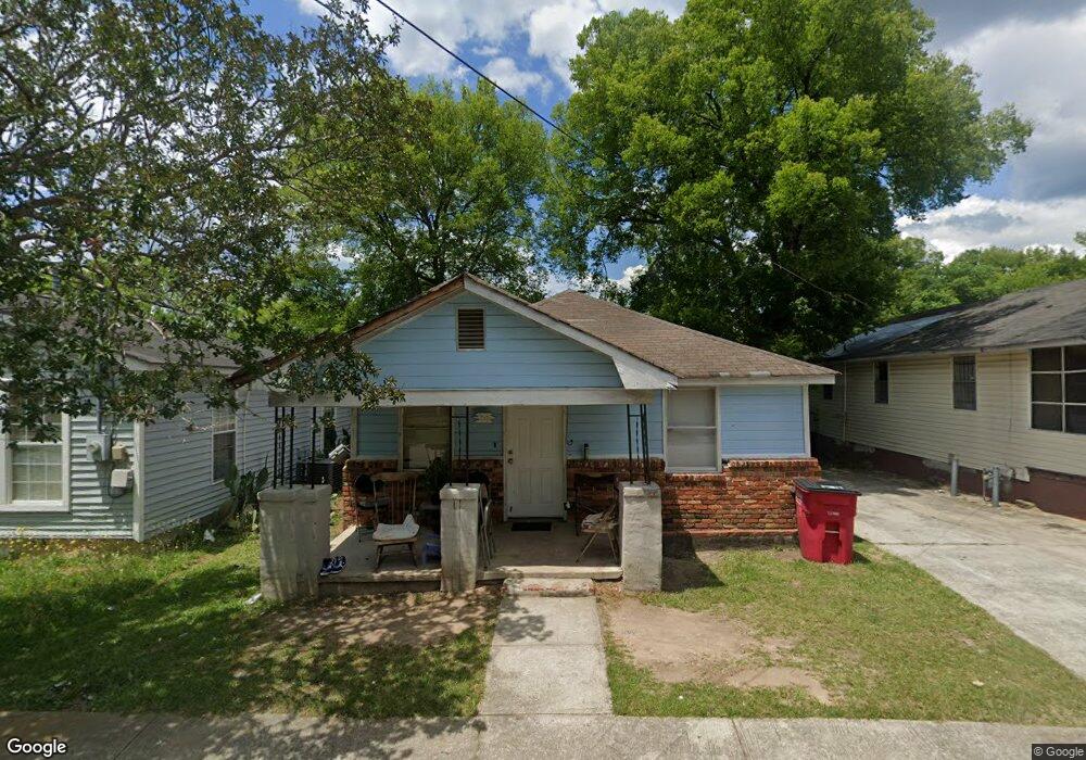
1321 Dent St Macon, GA 31206
Estimated Value: $52,000 - $77,000
2
Beds
1
Bath
774
Sq Ft
$76/Sq Ft
Est. Value
About This Home
This home is located at 1321 Dent St, Macon, GA 31206 and is currently estimated at $59,029, approximately $76 per square foot. 1321 Dent St is a home located in Bibb County with nearby schools including Hartley Elementary School, Southwest High School, and Cirrus Charter Academy.
Ownership History
Date
Name
Owned For
Owner Type
Purchase Details
Closed on
Jun 28, 2019
Sold by
Mq Properties Llc
Bought by
Sfh69 Llc
Current Estimated Value
Purchase Details
Closed on
Jun 27, 2019
Sold by
Macon 25 Llc
Bought by
Mq Properties Llc
Purchase Details
Closed on
Feb 21, 2014
Sold by
Priority Real Estate Invsmts
Bought by
Macon 25 Llc
Purchase Details
Closed on
Oct 7, 2009
Sold by
Odian Properties Llc
Bought by
Priority Real Estate Invsmts
Purchase Details
Closed on
Oct 31, 2007
Bought by
Odian Properties Llc
Purchase Details
Closed on
Mar 1, 2005
Purchase Details
Closed on
Jan 22, 2004
Create a Home Valuation Report for This Property
The Home Valuation Report is an in-depth analysis detailing your home's value as well as a comparison with similar homes in the area
Home Values in the Area
Average Home Value in this Area
Purchase History
| Date | Buyer | Sale Price | Title Company |
|---|---|---|---|
| Sfh69 Llc | $2,000,000 | None Available | |
| Mq Properties Llc | $408,800 | None Available | |
| Macon 25 Llc | $465,000 | -- | |
| Priority Real Estate Invsmts | -- | -- | |
| Odian Properties Llc | $430,000 | -- | |
| -- | $270,000 | -- | |
| -- | $130,000 | -- |
Source: Public Records
Tax History Compared to Growth
Tax History
| Year | Tax Paid | Tax Assessment Tax Assessment Total Assessment is a certain percentage of the fair market value that is determined by local assessors to be the total taxable value of land and additions on the property. | Land | Improvement |
|---|---|---|---|---|
| 2025 | $426 | $17,341 | $1,440 | $15,901 |
| 2024 | $440 | $17,341 | $1,440 | $15,901 |
| 2023 | $359 | $14,151 | $900 | $13,251 |
| 2022 | $424 | $12,238 | $3,866 | $8,372 |
| 2021 | $465 | $12,238 | $3,866 | $8,372 |
| 2020 | $475 | $12,238 | $3,866 | $8,372 |
| 2019 | $420 | $10,736 | $3,866 | $6,870 |
| 2018 | $824 | $10,736 | $3,866 | $6,870 |
| 2017 | $402 | $10,736 | $3,866 | $6,870 |
| 2016 | $371 | $10,737 | $3,866 | $6,870 |
| 2015 | $526 | $10,737 | $3,866 | $6,870 |
| 2014 | $322 | $5,720 | $1,392 | $4,328 |
Source: Public Records
Map
Nearby Homes
- 1049 Anthony Rd
- 1045 Anthony Rd
- 2349 Mason St
- 2249 Lowe St
- 2125 Cedar Ave
- 1191 Carroll St
- 2350 Anthony Terrace
- 1545 Anthony Rd
- 1144 Carroll St
- 2420 Adams Ave
- 1121 Carroll St
- 2032 Vining Cir
- 210 Moseley Ave
- 710 Poppy Ave
- 777 Grosso Ave
- 755 Grosso Ave
- 742 Grayson Ave
- 576 Pansy Ave
- 815 Edwards Ave
- 466 Petunia Ave
- 1325 Dent St
- 1315 Dent St
- 1320 Crawford St
- 1322 Crawford St
- 1318 Crawford St
- 1316 Dent St
- 1324 Crawford St
- 1320 Dent St
- 1331 Dent
- 1332 Dent St
- 1326 Crawford St
- 1336 Dent St
- 1328 Crawford St
- 1337 Dent St
- 1321 Crawford St
- 1319 Crawford St
- 1338 Dent St
- 1323 Crawford St
- 1317 Crawford St
- 1330 Crawford St