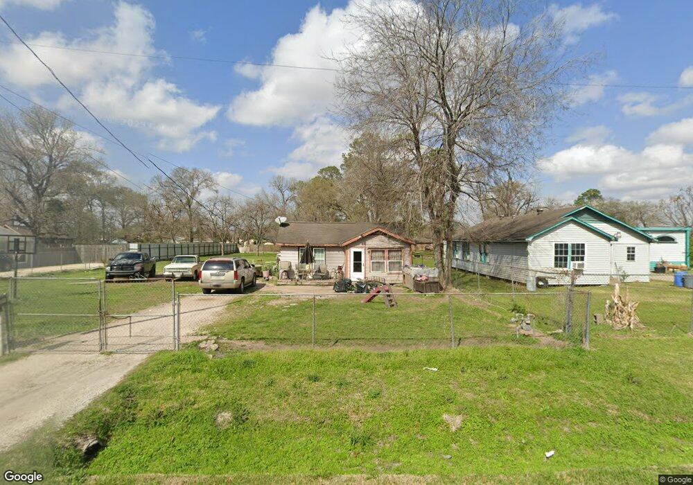
1321 Knight St Houston, TX 77022
Northside-Northline NeighborhoodEstimated Value: $271,000 - $357,000
2
Beds
1
Bath
896
Sq Ft
$343/Sq Ft
Est. Value
About This Home
This home is located at 1321 Knight St, Houston, TX 77022 and is currently estimated at $307,129, approximately $342 per square foot. 1321 Knight St is a home located in Harris County with nearby schools including Burbank Elementary School, Burbank Middle School, and Sam Houston Math, Science & Technology Center.
Ownership History
Date
Name
Owned For
Owner Type
Purchase Details
Closed on
Nov 4, 2011
Sold by
Herrera Alicia
Bought by
Rodriguez Alejandro and Cavazos Concepcion
Current Estimated Value
Home Financials for this Owner
Home Financials are based on the most recent Mortgage that was taken out on this home.
Original Mortgage
$110,000
Outstanding Balance
$75,443
Interest Rate
4.14%
Mortgage Type
Seller Take Back
Estimated Equity
$231,686
Create a Home Valuation Report for This Property
The Home Valuation Report is an in-depth analysis detailing your home's value as well as a comparison with similar homes in the area
Home Values in the Area
Average Home Value in this Area
Purchase History
| Date | Buyer | Sale Price | Title Company |
|---|---|---|---|
| Rodriguez Alejandro | $120,000 | None Available |
Source: Public Records
Mortgage History
| Date | Status | Borrower | Loan Amount |
|---|---|---|---|
| Open | Rodriguez Alejandro | $110,000 |
Source: Public Records
Tax History Compared to Growth
Tax History
| Year | Tax Paid | Tax Assessment Tax Assessment Total Assessment is a certain percentage of the fair market value that is determined by local assessors to be the total taxable value of land and additions on the property. | Land | Improvement |
|---|---|---|---|---|
| 2025 | $1,981 | $330,737 | $275,880 | $54,857 |
| 2024 | $1,981 | $307,083 | $253,193 | $53,890 |
| 2023 | $1,981 | $237,773 | $154,275 | $83,498 |
| 2022 | $4,374 | $219,626 | $154,275 | $65,351 |
| 2021 | $4,209 | $202,890 | $154,275 | $48,615 |
| 2020 | $3,975 | $196,802 | $154,275 | $42,527 |
| 2019 | $3,776 | $171,969 | $127,050 | $44,919 |
| 2018 | $1,567 | $141,656 | $106,178 | $35,478 |
| 2017 | $3,119 | $141,656 | $106,178 | $35,478 |
| 2016 | $2,835 | $134,757 | $99,825 | $34,932 |
| 2015 | $1,365 | $101,936 | $72,600 | $29,336 |
| 2014 | $1,365 | $101,936 | $72,600 | $29,336 |
Source: Public Records
Map
Nearby Homes
- 1207 Firnat St
- 1104 Charnwood St
- 8109 W Hardy Rd
- 723 Doverside St
- 807 Firnat St
- 8411 Berry Brush Ln
- 743 Apache St
- 1016 Apache St
- 8402 Berry Green Ln
- 802 Berry Sage Ln
- 631 Apache St
- 714 Apache St
- 702 Pennington St
- 8718 Brannon St
- 9026 Mcgallion Rd
- 88 Berry Rd
- 741 Mcdaniel St
- 8205 Appleton St
- 726 Mcdaniel St
- 411 Berry Rd
- 1401 Knight St
- 1313 Knight St
- 1309 Knight St
- 1413 Knight St
- 1314 Knight St
- 1301 Knight St
- 1419 Knight St
- 1322 Knight St
- 1402 Knight St
- 1406 Knight St
- 1408 Firnat St
- 1412 Firnat St
- 1406 Firnat St
- 1324 Firnat St
- 1213 Knight St
- 1302 Knight St
- 8813 W Hardy Rd
- 1320 Firnat St
- 1410 Firnat St Unit 1
- 1414 Knight St