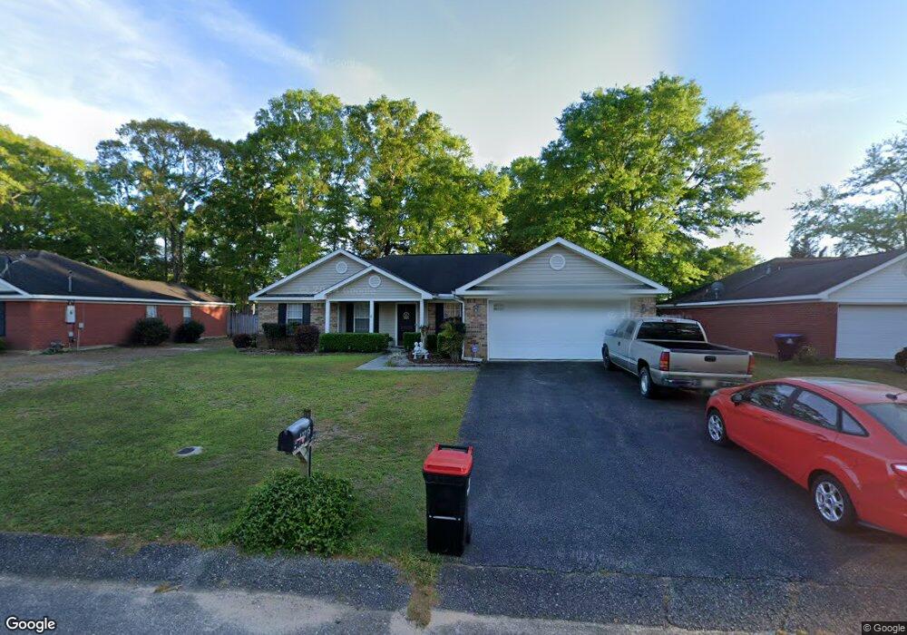
13215 Oak Forge Dr Mobile, AL 36608
Outer West Mobile NeighborhoodEstimated Value: $221,000 - $253,000
3
Beds
2
Baths
1,714
Sq Ft
$139/Sq Ft
Est. Value
About This Home
This home is located at 13215 Oak Forge Dr, Mobile, AL 36608 and is currently estimated at $237,515, approximately $138 per square foot. 13215 Oak Forge Dr is a home located in Mobile County with nearby schools including Hutchens Elementary School, Dawes Intermediate School, and Bernice J Causey Middle School.
Ownership History
Date
Name
Owned For
Owner Type
Purchase Details
Closed on
Dec 19, 2007
Sold by
Sanders Donna J
Bought by
Grant George H and Grant Rose M
Current Estimated Value
Purchase Details
Closed on
Sep 30, 1999
Sold by
Dbw Contractors Inc
Bought by
Eubanks Harold Z
Home Financials for this Owner
Home Financials are based on the most recent Mortgage that was taken out on this home.
Original Mortgage
$105,446
Interest Rate
7.89%
Mortgage Type
FHA
Create a Home Valuation Report for This Property
The Home Valuation Report is an in-depth analysis detailing your home's value as well as a comparison with similar homes in the area
Home Values in the Area
Average Home Value in this Area
Purchase History
| Date | Buyer | Sale Price | Title Company |
|---|---|---|---|
| Grant George H | $156,500 | None Available | |
| Eubanks Harold Z | -- | -- |
Source: Public Records
Mortgage History
| Date | Status | Borrower | Loan Amount |
|---|---|---|---|
| Previous Owner | Eubanks Harold Z | $105,446 |
Source: Public Records
Tax History Compared to Growth
Tax History
| Year | Tax Paid | Tax Assessment Tax Assessment Total Assessment is a certain percentage of the fair market value that is determined by local assessors to be the total taxable value of land and additions on the property. | Land | Improvement |
|---|---|---|---|---|
| 2024 | -- | $21,350 | $3,600 | $17,750 |
| 2023 | $0 | $17,580 | $3,600 | $13,980 |
| 2022 | $0 | $16,030 | $3,000 | $13,030 |
| 2021 | $356 | $13,470 | $3,000 | $10,470 |
| 2020 | $0 | $13,760 | $3,000 | $10,760 |
| 2019 | $0 | $13,160 | $0 | $0 |
| 2018 | $0 | $13,420 | $0 | $0 |
| 2017 | $0 | $13,540 | $0 | $0 |
| 2016 | -- | $13,700 | $0 | $0 |
| 2013 | -- | $13,660 | $0 | $0 |
Source: Public Records
Map
Nearby Homes
- 2865 Barlett Dr
- 13190 Hackberry Dr
- #77 Deer Crest Dr
- 0 Deer Crest Ln Unit 7676050
- 00 Deer Crest Ln
- 2760 Wildflower Dr W
- 0 Newman Rd Unit 7559706
- 0 Newman Rd Unit 22348691
- 0 Newman Rd Unit 7559703
- 0 Newman Rd Unit 7559705
- 0 Newman Rd Unit 25399577
- 0 Newman Rd Unit 7559708
- 0 Newman Rd Unit 7559711
- 0 Newman Rd Unit 7493775
- 0 Newman Rd Unit 7670125
- 0 Newman Rd Unit 22348697
- 0 Newman Rd Unit 7652668
- 0 Newman Rd Unit 7499863
- 14201 Airport Blvd
- 12171 Yancey Glen Dr
- 13205 Oak Forge Dr
- 13225 Oak Forge Dr
- 13195 Oak Forge Dr
- 13235 Oak Forge Dr
- 13230 Hackberry Dr
- 13220 Hackberry Dr
- 13240 Hackberry Dr
- 13185 Oak Forge Dr
- 13210 Hackberry Dr
- 13220 Oak Forge Dr Unit 2
- 13210 Oak Forge Dr
- 13250 Hackberry Dr
- 13230 Oak Forge Dr
- 13230 Oak Forge Dr Unit 51
- 13245 Oak Forge Dr
- 13200 Oak Forge Dr
- 13200 Hackberry Dr
- 2845 Barlett Dr
- 13240 Oak Forge Dr
- 13240 Oak Forge Dr Unit 46