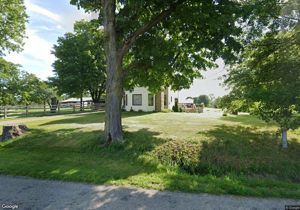
13230 Basil Rd NW Baltimore, OH 43105
Estimated Value: $415,553 - $539,000
3
Beds
3
Baths
2,240
Sq Ft
$214/Sq Ft
Est. Value
About This Home
This home is located at 13230 Basil Rd NW, Baltimore, OH 43105 and is currently estimated at $480,138, approximately $214 per square foot. 13230 Basil Rd NW is a home located in Fairfield County with nearby schools including Kirkersville Elementary School, Etna Elementary School, and Watkins Middle School.
Ownership History
Date
Name
Owned For
Owner Type
Purchase Details
Closed on
Dec 15, 1997
Sold by
Foster David A
Bought by
Thompson Mark A and Thompson Lisa M
Current Estimated Value
Home Financials for this Owner
Home Financials are based on the most recent Mortgage that was taken out on this home.
Original Mortgage
$120,650
Outstanding Balance
$20,574
Interest Rate
7.32%
Mortgage Type
FHA
Estimated Equity
$459,564
Purchase Details
Closed on
Nov 5, 1993
Create a Home Valuation Report for This Property
The Home Valuation Report is an in-depth analysis detailing your home's value as well as a comparison with similar homes in the area
Home Values in the Area
Average Home Value in this Area
Purchase History
| Date | Buyer | Sale Price | Title Company |
|---|---|---|---|
| Thompson Mark A | $127,000 | -- | |
| -- | $105,000 | -- |
Source: Public Records
Mortgage History
| Date | Status | Borrower | Loan Amount |
|---|---|---|---|
| Open | Thompson Mark A | $120,650 |
Source: Public Records
Tax History Compared to Growth
Tax History
| Year | Tax Paid | Tax Assessment Tax Assessment Total Assessment is a certain percentage of the fair market value that is determined by local assessors to be the total taxable value of land and additions on the property. | Land | Improvement |
|---|---|---|---|---|
| 2024 | $6,609 | $88,390 | $26,950 | $61,440 |
| 2023 | $3,451 | $88,390 | $26,950 | $61,440 |
| 2022 | $3,423 | $88,390 | $26,950 | $61,440 |
| 2021 | $2,884 | $67,520 | $24,500 | $43,020 |
| 2020 | $2,951 | $67,520 | $24,500 | $43,020 |
| 2019 | $3,000 | $67,520 | $24,500 | $43,020 |
| 2018 | $2,496 | $51,800 | $21,560 | $30,240 |
| 2017 | $2,509 | $51,460 | $21,560 | $29,900 |
| 2016 | $2,474 | $51,460 | $21,560 | $29,900 |
| 2015 | $2,308 | $50,210 | $21,560 | $28,650 |
| 2014 | $2,216 | $50,210 | $21,560 | $28,650 |
| 2013 | $2,216 | $50,210 | $21,560 | $28,650 |
Source: Public Records
Map
Nearby Homes
- 13427 Snyder Church Rd NW
- 12644 Snyder Church Rd NW
- 10348 York Rd SW
- 7543 Palmer Rd SW
- 2597 Blacklick Eastern Rd NW
- 3980 Blacklick Rd NW
- 13165 Heimberger Rd NW
- 10123 Loop Rd
- 9797 York Rd SW
- 0 Loop Rd
- 11135 Basil Rd NW
- 13254 Brandon Mill Dr NW
- 11130 Smoke Rd SW
- 13673 Cherry Ln
- 9952 Loop Rd
- 0 Heimberger Rd NW Unit 224007682
- 7913 National Rd SW Unit Lot 34
- 10293 Smoke Rd SW
- 112 Spring Brook Ct
- 71 Cosmos Ln SW
- 13244 Basil Rd NW
- 13235 Basil Rd NW
- 13181 Basil Rd NW
- 13170 Basil Rd NW
- 13340 Basil Rd NW
- 13145 Basil Rd NW
- 13319 Basil Rd NW
- 13109 Basil Rd NW
- 13110 Basil Rd NW
- 13410 Basil Rd NW
- 13015 Basil Rd NW
- 13349 Basil Rd NW
- 12995 Basil Rd NW
- 2451 Blacklick Rd NW
- 2345 Blacklick Rd NW
- 13205 Basil Rd NW
- 2511 Blacklick Rd NW
- 0 Blacklick Rd NW Unit 2720080
- 0 Blacklick Rd NW Unit 2531091
- 0 Blacklick Rd NW Unit 2514497