


1325 Frontier Rd Minneapolis, KS 67467
Estimated payment $1,360/month
Highlights
- 67.1 Acre Lot
- Stream or River on Lot
- No HOA
- Minneapolis High School Rated A-
- Partially Wooded Lot
- Partially Fenced Property
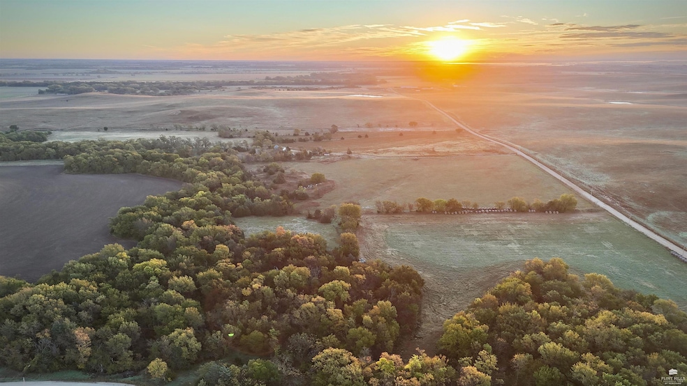
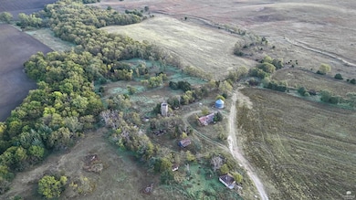
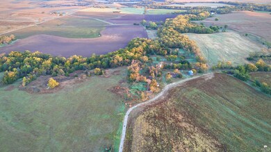
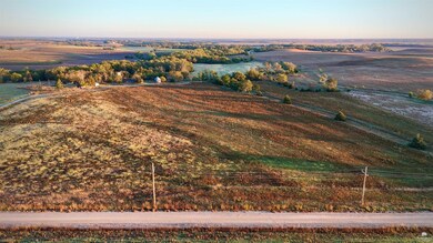
About This Lot
This remarkable property is the epitome of versatility, offering tillable ground, warm-weather native grass and brome hay field, alfalfa, a meandering section of Battle Creek, and excellent hunting opportunities. The wet weather creek is a hardwood draw creating a great travel corridor for deer, and is the northern and western border of the property. The property is located within Kansas Deer Management Unit 7 and shows promise of holding great whitetail deer. The timber is a mixture of elm, eastern red cedar, and hedge trees. The tillable acres consist of approximately 25 acres of Class II and 30 acres of Class III Hord, Crete, and Geary silt loams. The soils have an NCCPI overall weighted score of 67. With usable outbuildings, a grain bin, and existing utilities, this land is ready for a new home and a new story.

Property Details
Property Type
- Land
Est. Annual Taxes
- $614
Lot Details
- 67.1 Acre Lot
- Partially Fenced Property
- Partially Wooded Lot
Community Details
Overview
- No Home Owners Association
Recreation
- Stream or River on Lot
Map
Home Values in the Area
Average Home Value in this Area
Tax History
| Year | Tax Paid | Tax Assessment Tax Assessment Total Assessment is a certain percentage of the fair market value that is determined by local assessors to be the total taxable value of land and additions on the property. | Land | Improvement |
|---|---|---|---|---|
| 2025 | $615 | $3,673 | $3,660 | $13 |
| 2024 | $615 | $4,059 | $4,044 | $15 |
| 2023 | $777 | $4,516 | $4,503 | $13 |
| 2022 | $849 | $4,911 | $4,791 | $120 |
| 2021 | $1,207 | $4,967 | $4,857 | $110 |
| 2020 | $1,207 | $7,807 | $5,449 | $2,358 |
| 2019 | $1,270 | $7,737 | $5,335 | $2,402 |
| 2018 | $1,227 | $7,534 | $5,164 | $2,370 |
| 2017 | $1,287 | $7,808 | $4,780 | $3,028 |
| 2016 | $1,326 | $7,920 | $4,300 | $3,620 |
| 2015 | -- | $7,500 | $4,024 | $3,476 |
| 2014 | -- | $12,754 | $9,177 | $3,577 |
Property History
| Date | Event | Price | List to Sale | Price per Sq Ft |
|---|---|---|---|---|
| 11/01/2025 11/01/25 | Pending | -- | -- | -- |
| 10/22/2025 10/22/25 | For Sale | $248,270,000 | -- | -- |
Source: Flint Hills Association of REALTORS®
MLS Number: FHR20252842
APN: 139-32-0-00-00-006.00-0
Disclaimer: Certain information contained herein is derived from information provided by parties other than Homes.com. All information provided is deemed reliable, but is not guaranteed to be accurate and should be independently verified.
![]() IDX information is provided exclusively for consumers' personal, non-commercial use and may not be used for any purpose other than to identify prospective properties consumers may be interested in purchasing.
IDX information is provided exclusively for consumers' personal, non-commercial use and may not be used for any purpose other than to identify prospective properties consumers may be interested in purchasing.
Listing information is deemed reliable, but not guaranteed.
- 116 W 4th St
- 608 N Concord St
- 222 Mackenzie St
- 813 N Rock St
- 532 Laurel St
- 725 Argyle Ave
- 443 Meadowlark Dr
- 720 Marilyn St
- 326 N 140th Rd
- 00000 Frontier Rd
- 1943 Frontier Rd
- 00000 N 20th Rd
- 1449 Oxbow Rd
- 361 N Minnesota Ave
- 0000 Rifle Rd
- 0000 Aspen Rd
- 1191 Sunset Rd
- 0 Ivy Rd
- 00000 N 170th Rd L3 Blk 2
- 00000 N 170th Rd L2 Blk 4