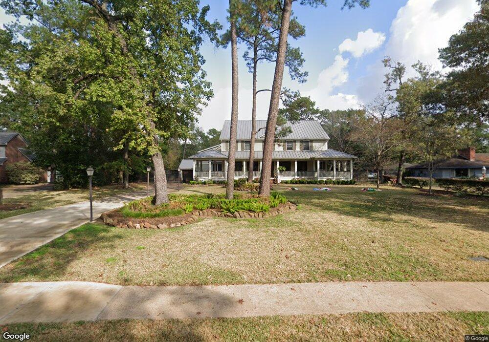
1326 Sue Barnett Dr Houston, TX 77018
Oak Forest-Garden Oaks NeighborhoodEstimated Value: $1,169,000 - $2,202,565
4
Beds
5
Baths
3,711
Sq Ft
$490/Sq Ft
Est. Value
About This Home
This home is located at 1326 Sue Barnett Dr, Houston, TX 77018 and is currently estimated at $1,817,891, approximately $489 per square foot. 1326 Sue Barnett Dr is a home located in Harris County with nearby schools including Garden Oaks Montessori, Frank Black Middle School, and Waltrip High School.
Ownership History
Date
Name
Owned For
Owner Type
Purchase Details
Closed on
Jan 28, 2011
Sold by
Chang Peter Shun Hsien and Chang Peter S
Bought by
Chang Katherine M
Current Estimated Value
Home Financials for this Owner
Home Financials are based on the most recent Mortgage that was taken out on this home.
Original Mortgage
$551,200
Outstanding Balance
$378,603
Interest Rate
4.86%
Mortgage Type
Purchase Money Mortgage
Estimated Equity
$1,439,288
Purchase Details
Closed on
Sep 29, 2008
Sold by
Drake James A and Drake Linda W
Bought by
Chang Peter S
Home Financials for this Owner
Home Financials are based on the most recent Mortgage that was taken out on this home.
Original Mortgage
$417,000
Interest Rate
6.52%
Mortgage Type
Purchase Money Mortgage
Create a Home Valuation Report for This Property
The Home Valuation Report is an in-depth analysis detailing your home's value as well as a comparison with similar homes in the area
Home Values in the Area
Average Home Value in this Area
Purchase History
| Date | Buyer | Sale Price | Title Company |
|---|---|---|---|
| Chang Katherine M | -- | Commonwealth Title | |
| Chang Peter S | -- | None Available |
Source: Public Records
Mortgage History
| Date | Status | Borrower | Loan Amount |
|---|---|---|---|
| Open | Chang Katherine M | $551,200 | |
| Closed | Chang Peter S | $417,000 |
Source: Public Records
Tax History Compared to Growth
Tax History
| Year | Tax Paid | Tax Assessment Tax Assessment Total Assessment is a certain percentage of the fair market value that is determined by local assessors to be the total taxable value of land and additions on the property. | Land | Improvement |
|---|---|---|---|---|
| 2025 | $30,539 | $2,712,439 | $1,194,282 | $1,518,157 |
| 2024 | $30,539 | $2,353,972 | $1,008,505 | $1,345,467 |
| 2023 | $30,539 | $1,702,777 | $811,109 | $891,668 |
| 2022 | $36,146 | $1,641,572 | $811,109 | $830,463 |
| 2021 | $36,849 | $1,581,069 | $811,109 | $769,960 |
| 2020 | $38,287 | $1,581,069 | $811,109 | $769,960 |
| 2019 | $39,688 | $1,568,417 | $811,109 | $757,308 |
| 2018 | $34,198 | $1,695,817 | $659,026 | $1,036,791 |
| 2017 | $40,634 | $1,695,817 | $659,026 | $1,036,791 |
| 2016 | $36,940 | $1,695,817 | $659,026 | $1,036,791 |
| 2015 | $24,779 | $1,503,497 | $659,026 | $844,471 |
| 2014 | $24,779 | $1,378,236 | $633,679 | $744,557 |
Source: Public Records
Map
Nearby Homes
- 4510 Curtin Park Ct
- 814 Azalea St
- 830 Azalea St
- 739 Azaleadell Dr
- 535 Azaleadell Dr
- 702 Azaleadell Dr
- 991 Curtin St
- 817 Thornton Rd Unit G
- 9388 Plan at Thornton Oaks
- 9384 Plan at Thornton Oaks
- 752 Curtin St
- 750 Curtin St
- 748 Curtin St
- 811 Thornton Rd Unit B
- 744 Curtin St
- 742 Curtin St
- 812 Thornton Rd Unit B
- 903 W 43rd St
- 934 W 43rd St
- 719 Thornton Rd Unit B
- 1328 Sue Barnett Dr
- 1324 Sue Barnett Dr
- 943 Chamboard Ln
- 1318 Sue Barnett Dr
- 949 Chamboard Ln
- 1336 Sue Barnett Dr
- 1321 Sue Barnett Dr
- 1317 Sue Barnett Dr
- 955 Chamboard Ln
- 4504 Curtin Park Ct
- 1315 Sue Barnett Dr
- 1327 Sue Barnett Dr
- 4506 Curtin Park Ct
- 921 Curtin St
- 942 Chamboard Ln
- 1314 Sue Barnett Dr
- 1338 Sue Barnett Dr
- 946 Chamboard Ln
- 959 Chamboard Ln
- 1329 Sue Barnett Dr