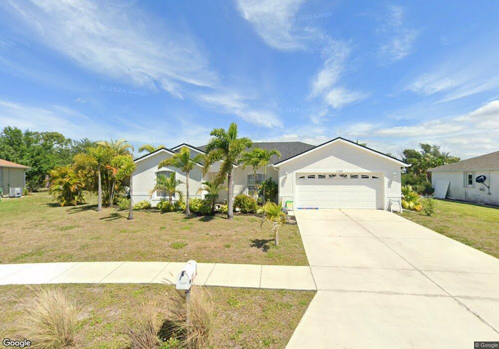
13268 Darnell Ave Port Charlotte, FL 33981
Gulf Cove NeighborhoodEstimated Value: $256,000 - $301,000
3
Beds
2
Baths
1,455
Sq Ft
$193/Sq Ft
Est. Value
About This Home
This home is located at 13268 Darnell Ave, Port Charlotte, FL 33981 and is currently estimated at $281,068, approximately $193 per square foot. 13268 Darnell Ave is a home located in Charlotte County with nearby schools including Myakka River Elementary School, L.A. Ainger Middle School, and Lemon Bay High School.
Ownership History
Date
Name
Owned For
Owner Type
Purchase Details
Closed on
Aug 23, 2002
Sold by
Allstate Bldr Sw Fl Inc
Bought by
Rheaume John and Rheaume Nancy
Current Estimated Value
Home Financials for this Owner
Home Financials are based on the most recent Mortgage that was taken out on this home.
Original Mortgage
$93,250
Outstanding Balance
$38,781
Interest Rate
6.31%
Estimated Equity
$242,287
Purchase Details
Closed on
Feb 13, 2002
Sold by
T N R Co Inc
Bought by
Allstate Bldr Sw Fl Inc
Create a Home Valuation Report for This Property
The Home Valuation Report is an in-depth analysis detailing your home's value as well as a comparison with similar homes in the area
Home Values in the Area
Average Home Value in this Area
Purchase History
| Date | Buyer | Sale Price | Title Company |
|---|---|---|---|
| Rheaume John | $116,600 | -- | |
| Allstate Bldr Sw Fl Inc | $21,000 | -- |
Source: Public Records
Mortgage History
| Date | Status | Borrower | Loan Amount |
|---|---|---|---|
| Open | Rheaume John | $93,250 |
Source: Public Records
Tax History Compared to Growth
Tax History
| Year | Tax Paid | Tax Assessment Tax Assessment Total Assessment is a certain percentage of the fair market value that is determined by local assessors to be the total taxable value of land and additions on the property. | Land | Improvement |
|---|---|---|---|---|
| 2023 | $2,229 | $121,816 | $0 | $0 |
| 2022 | $2,124 | $118,268 | $0 | $0 |
| 2021 | $2,108 | $114,823 | $0 | $0 |
| 2020 | $2,059 | $113,238 | $0 | $0 |
| 2019 | $1,971 | $110,692 | $0 | $0 |
| 2018 | $1,604 | $107,653 | $0 | $0 |
| 2017 | $1,582 | $105,439 | $0 | $0 |
| 2016 | $1,567 | $103,270 | $0 | $0 |
| 2015 | $1,554 | $102,552 | $0 | $0 |
| 2014 | $1,528 | $101,738 | $0 | $0 |
Source: Public Records
Map
Nearby Homes
- 13208 Foresman Blvd
- 12475 Sunniland Ave
- 13264 Foresman Blvd
- 13316 Darnell Ave
- 13280 Foresman Blvd
- 13301 Foresman Blvd
- 13266 Drysdale Ave
- 13309 Foresman Blvd
- 13144 Eureka Lot 18 Cir
- 6219 Coliseum Blvd
- 13367 Darnell Ave
- 13284 Buckett Cir
- 6030 Broker Ct
- 13384 Darnell Ave
- 5576 Joslyn Terrace
- 13297 Flaherty Ave
- 13360 Foresman Blvd
- 13363 Drysdale Ave
- 13315 Flaherty Ave
- 13323 Flaherty Ave
- 13276 Darnell Ave
- 13260 Darnell Ave
- 13257 Darnell Ave
- 13284 Darnell Ave
- 13252 Darnell Ave
- 13277 Darnell Ave
- 13239 Foresman Blvd
- 13285 Darnell Ave
- 13292 Darnell Ave
- 13244 Darnell Ave
- 13237 Darnell Ave
- 13255 Foresman Blvd
- 6154 Coliseum Blvd
- 13293 Darnell Ave
- 13300 Darnell Ave
- 13236 Darnell Ave
- 6162 Coliseum Blvd
- 6076 + 6084 Coliseum Blvd
- 6170 Coliseum Blvd
- 13308 Darnell Ave