Estimated Value: $213,634 - $231,000
3
Beds
2
Baths
1,101
Sq Ft
$204/Sq Ft
Est. Value
About This Home
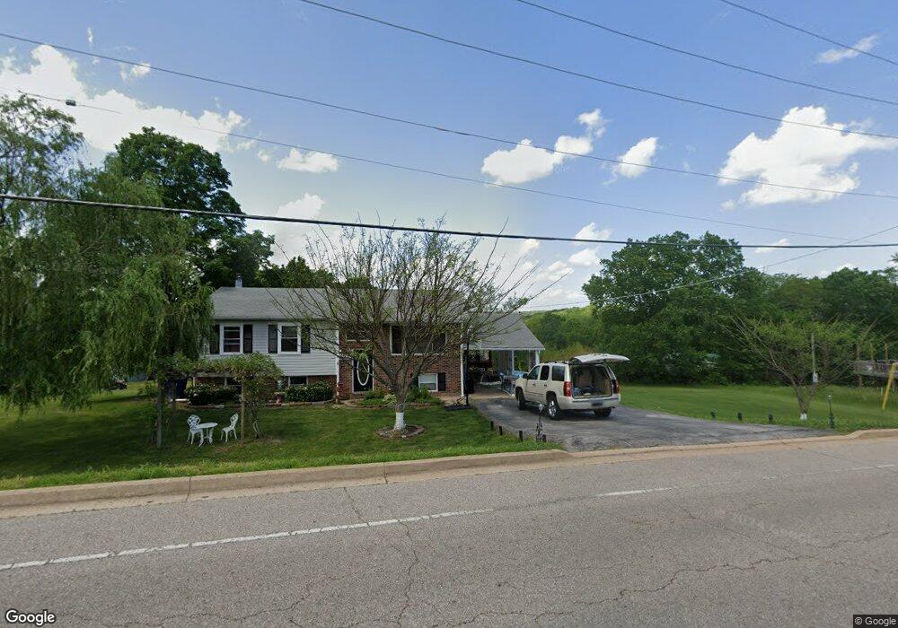
This home is located at 1327 W Main St, Union, MO 63084 and is currently estimated at $224,878, approximately $204 per square foot. 1327 W Main St is a home located in Franklin County with nearby schools including Union High School and Immaculate Conception School.
Ownership History
Date
Name
Owned For
Owner Type
Purchase Details
Closed on
Mar 30, 2020
Sold by
King David E and King Kendra B
Bought by
King David E and King Kendra B
Current Estimated Value
Create a Home Valuation Report for This Property
The Home Valuation Report is an in-depth analysis detailing your home's value as well as a comparison with similar homes in the area
Home Values in the Area
Average Home Value in this Area
Purchase History
| Date | Buyer | Sale Price | Title Company |
|---|---|---|---|
| King David E | -- | None Available |
Source: Public Records
Tax History
| Year | Tax Paid | Tax Assessment Tax Assessment Total Assessment is a certain percentage of the fair market value that is determined by local assessors to be the total taxable value of land and additions on the property. | Land | Improvement |
|---|---|---|---|---|
| 2025 | $1,842 | $30,896 | $0 | $0 |
| 2024 | $1,842 | $25,732 | $0 | $0 |
| 2023 | $1,551 | $25,732 | $0 | $0 |
| 2022 | $1,392 | $23,055 | $0 | $0 |
| 2021 | $1,395 | $23,055 | $0 | $0 |
| 2020 | $1,302 | $21,184 | $0 | $0 |
| 2019 | $1,299 | $21,184 | $0 | $0 |
| 2018 | $1,195 | $20,448 | $0 | $0 |
| 2017 | $1,198 | $20,448 | $0 | $0 |
| 2016 | $1,192 | $19,884 | $0 | $0 |
| 2015 | $1,173 | $19,884 | $0 | $0 |
| 2014 | $1,176 | $19,920 | $0 | $0 |
Source: Public Records
Map
Nearby Homes
- 54 Hickory Cir
- 626 Lindsey Dr
- 4 Lindner Ln
- 914 W State St
- 26 & 30 Ridge Point Meadows
- 21 Forest Ln
- 0 Lot 5 Clearview Dr Unit 19010510
- 0 Lot 3 Clearview Dr Unit MIS26011988
- 0 Lot 4 Clearview Dr Unit 19010507
- 0 Lot 6 Clearview Dr Unit 19010511
- 0 Clearview Unit 19010495
- 725 W Main St
- 413 Rosedale Ave
- 702 Clearview Dr Unit 1
- 613 W State St
- 154 Joel Ave
- 408 Hall Ave
- 413 W State St
- 0 Heard Ct
- 1008 N Washington Ave
- 1325 W Main St
- 1329 W Main St
- 108 Wildcat Ct
- 102 Wildcat Ct
- 1331 W Main St
- 114 Wildcat Ct
- 118 Wildcat Ct
- 1333 W Main (Continue To Show!)
- 1334 W Main St
- 101 Wildcat Ct
- 124 Wildcat Ct
- 105 Wildcat Ct
- 109 Wildcat Ct
- 128 Wildcat Ct
- 1338 W Main St
- 1341 W Main St
- 1341 W Main St
- 1320 W Main St
- 113 Wildcat Ct
- 11 Wildcat Dr
Your Personal Tour Guide
Ask me questions while you tour the home.