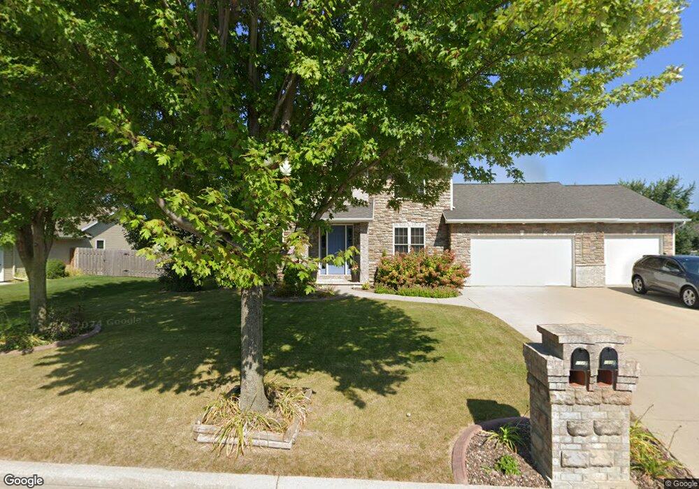
1327 Winter Wheat Dr Neenah, WI 54956
Estimated Value: $499,619 - $551,000
4
Beds
4
Baths
1,210
Sq Ft
$431/Sq Ft
Est. Value
About This Home
This home is located at 1327 Winter Wheat Dr, Neenah, WI 54956 and is currently estimated at $521,405, approximately $430 per square foot. 1327 Winter Wheat Dr is a home located in Winnebago County with nearby schools including Lakeview Elementary School, Horace Mann Middle School, and Neenah Middle School.
Ownership History
Date
Name
Owned For
Owner Type
Purchase Details
Closed on
Sep 10, 2007
Sold by
Parker Thomas and Parkar Angela
Bought by
Wypiszynski Andrew T and Wypiszynski Dawn M
Current Estimated Value
Home Financials for this Owner
Home Financials are based on the most recent Mortgage that was taken out on this home.
Original Mortgage
$216,400
Outstanding Balance
$137,430
Interest Rate
6.63%
Mortgage Type
New Conventional
Estimated Equity
$383,975
Create a Home Valuation Report for This Property
The Home Valuation Report is an in-depth analysis detailing your home's value as well as a comparison with similar homes in the area
Home Values in the Area
Average Home Value in this Area
Purchase History
| Date | Buyer | Sale Price | Title Company |
|---|---|---|---|
| Wypiszynski Andrew T | $270,500 | None Available |
Source: Public Records
Mortgage History
| Date | Status | Borrower | Loan Amount |
|---|---|---|---|
| Open | Wypiszynski Andrew T | $216,400 |
Source: Public Records
Tax History Compared to Growth
Tax History
| Year | Tax Paid | Tax Assessment Tax Assessment Total Assessment is a certain percentage of the fair market value that is determined by local assessors to be the total taxable value of land and additions on the property. | Land | Improvement |
|---|---|---|---|---|
| 2024 | $6,774 | $437,500 | $47,000 | $390,500 |
| 2023 | $6,774 | $437,500 | $47,000 | $390,500 |
| 2022 | $6,536 | $321,500 | $46,500 | $275,000 |
| 2021 | $6,613 | $320,500 | $46,500 | $274,000 |
| 2020 | $6,693 | $320,500 | $46,500 | $274,000 |
| 2019 | $6,268 | $320,500 | $46,500 | $274,000 |
| 2018 | $5,397 | $237,400 | $43,600 | $193,800 |
| 2017 | $5,365 | $237,400 | $43,600 | $193,800 |
| 2016 | $5,338 | $237,400 | $43,600 | $193,800 |
| 2015 | $5,373 | $237,400 | $43,600 | $193,800 |
| 2014 | $5,428 | $237,400 | $43,600 | $193,800 |
| 2013 | $5,691 | $237,400 | $43,600 | $193,800 |
Source: Public Records
Map
Nearby Homes
- 1599 Redwing Dr
- 1562 Lone Oak Dr
- 1516 Kingswood Dr
- 1539 Freedom Meadows Dr
- 1535 Freedom Meadows Dr
- 1468 Plains Ave
- 1433 Freedom Ct
- 1715 Sovereign Way
- 1738 Sovereign Way
- 1711 Sovereign Way
- 1442 Baytree Ln
- 1721 Freeman Dr
- 1650 Founders St
- 1785 Honor St
- 1762 Loyal Dr
- 1799 Legacy Ln
- 1641-HA-51 Plan at Freedom Meadows
- 1600-CH-55 Plan at Freedom Meadows
- 1365-BA-53.6 Plan at Freedom Meadows
- 1456-HA-48 Plan at Freedom Meadows
- 1323 Winter Wheat Dr
- 1331 Winter Wheat Dr
- 1331 1331 Winter Wheat
- 1614 Lone Oak Dr
- 1615 Remington Ct
- 1326 Winter Wheat Dr
- 1319 Winter Wheat Dr
- 1322 Winter Wheat Dr
- 1330 Winter Wheat Dr
- 1608 Lone Oak Dr
- 1619 Remington Ct
- 1627 Remington Ct
- 1627 Remington Ct
- 1611 Remington Ct
- 1318 Winter Wheat Dr
- 1621 Lone Oak Dr
- 1617 Lone Oak Dr
- 0 Remington Ct
- 0 Remington Ct
- 0 Remington Ct