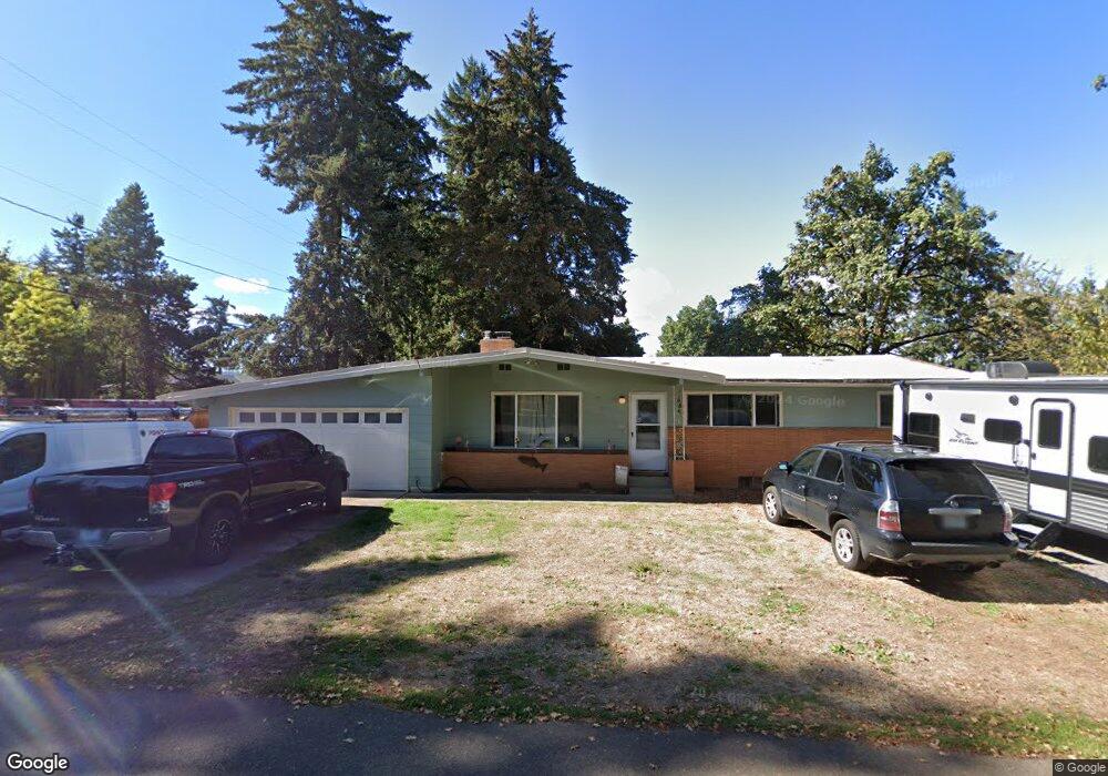
13283 SE Maple Ln Milwaukie, OR 97222
Estimated Value: $387,000 - $427,485
3
Beds
1
Bath
1,008
Sq Ft
$410/Sq Ft
Est. Value
About This Home
This home is located at 13283 SE Maple Ln, Milwaukie, OR 97222 and is currently estimated at $412,871, approximately $409 per square foot. 13283 SE Maple Ln is a home located in Clackamas County with nearby schools including Oak Grove Elementary School, Alder Creek Middle School, and Rex Putnam High School.
Ownership History
Date
Name
Owned For
Owner Type
Purchase Details
Closed on
Mar 12, 2019
Sold by
Wright Robert L
Bought by
Mather Michael J
Current Estimated Value
Home Financials for this Owner
Home Financials are based on the most recent Mortgage that was taken out on this home.
Original Mortgage
$235,653
Outstanding Balance
$208,706
Interest Rate
4.87%
Mortgage Type
FHA
Estimated Equity
$204,165
Purchase Details
Closed on
May 7, 2007
Sold by
Wright Robert L and Wright Mary L
Bought by
Fernando Nilaksha P
Create a Home Valuation Report for This Property
The Home Valuation Report is an in-depth analysis detailing your home's value as well as a comparison with similar homes in the area
Home Values in the Area
Average Home Value in this Area
Purchase History
| Date | Buyer | Sale Price | Title Company |
|---|---|---|---|
| Mather Michael J | $240,000 | Fidelity National Title | |
| Fernando Nilaksha P | $270,000 | Fidelity Natl Title Co Of Or |
Source: Public Records
Mortgage History
| Date | Status | Borrower | Loan Amount |
|---|---|---|---|
| Open | Mather Michael J | $235,653 |
Source: Public Records
Tax History Compared to Growth
Tax History
| Year | Tax Paid | Tax Assessment Tax Assessment Total Assessment is a certain percentage of the fair market value that is determined by local assessors to be the total taxable value of land and additions on the property. | Land | Improvement |
|---|---|---|---|---|
| 2025 | $3,913 | $205,045 | -- | -- |
| 2024 | $3,775 | $199,073 | -- | -- |
| 2023 | $3,775 | $193,275 | $0 | $0 |
| 2022 | $3,473 | $187,646 | $0 | $0 |
| 2021 | $3,346 | $182,181 | $0 | $0 |
| 2020 | $3,242 | $176,875 | $0 | $0 |
| 2019 | $3,196 | $171,724 | $0 | $0 |
| 2018 | $2,799 | $166,722 | $0 | $0 |
| 2017 | $2,711 | $161,866 | $0 | $0 |
| 2016 | $2,615 | $157,151 | $0 | $0 |
| 2015 | $2,541 | $152,574 | $0 | $0 |
| 2014 | $2,402 | $148,130 | $0 | $0 |
Source: Public Records
Map
Nearby Homes
- 3396 SE Loeffelman Rd
- 12815 SE 31st Ave
- 12712 SE 31st Ave
- 12632 SE 39th Ct
- 13241 SE 45th Ave
- 4501 SE Chelsea St
- 13770 SE Linden Ln
- 12735 SE 26th Ave
- 13952 SE Piper Cub Way
- 13945 SE Piper Cub Way
- 12425 SE 27th Ave
- 14047 SE Piper Cub Way
- 14437 SE Hillgrove Ct
- 4119 SE Northridge Dr
- 12600 SE Freeman Way
- 12556 SE 23rd Ave
- 4915 SE Hill Rd
- 14515 SE Wild Rose Ln
- 12437 SE 24th Ave
- 12838 SE Sprout Ln
- 13251 SE Maple Ln
- 3580 SE Snowberry St
- 3617 SE Snowberry St
- 3450 SE Snowberry St
- 13250 SE Maple Ln
- 3513 SE Snowberry St
- 13245 SE Maple Ln
- 13315 SE Maple Ln
- 3610 SE Snowberry St
- 13218 SE Briggs St
- 13127 SE Nixon Ave
- 13308 SE Briggs St
- 13222 SE Briggs St
- 13125 SE Nixon Ave
- 3640 SE Snowberry St
- 13411 SE Maple Ln
- 13206 SE Briggs St
- 13233 SE Maple Ln
- 13316 SE Briggs St
- 13431 SE Maple Ln