Estimated Value: $126,000 - $151,191
3
Beds
1
Bath
912
Sq Ft
$154/Sq Ft
Est. Value
About This Home
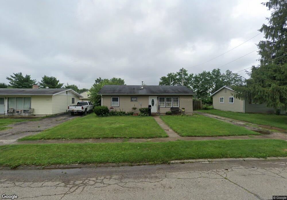
This home is located at 1329 Reid Ave, Xenia, OH 45385 and is currently estimated at $140,298, approximately $153 per square foot. 1329 Reid Ave is a home located in Greene County with nearby schools including Xenia High School, Summit Academy Community School for Alternative Learners - Xenia, and Legacy Christian Academy.
Ownership History
Date
Name
Owned For
Owner Type
Purchase Details
Closed on
Oct 4, 2007
Sold by
Rogers Kevin L and Rogers Lisa R
Bought by
Ashbaugh Rhonda L
Current Estimated Value
Home Financials for this Owner
Home Financials are based on the most recent Mortgage that was taken out on this home.
Original Mortgage
$63,158
Outstanding Balance
$40,005
Interest Rate
6.49%
Mortgage Type
Unknown
Estimated Equity
$100,293
Purchase Details
Closed on
Nov 20, 1997
Sold by
Brown Darla R
Bought by
Rogers Kevin L and Rogers R
Home Financials for this Owner
Home Financials are based on the most recent Mortgage that was taken out on this home.
Original Mortgage
$59,966
Interest Rate
7.38%
Mortgage Type
New Conventional
Create a Home Valuation Report for This Property
The Home Valuation Report is an in-depth analysis detailing your home's value as well as a comparison with similar homes in the area
Home Values in the Area
Average Home Value in this Area
Purchase History
| Date | Buyer | Sale Price | Title Company |
|---|---|---|---|
| Ashbaugh Rhonda L | $63,200 | Attorney | |
| Rogers Kevin L | $52,500 | -- |
Source: Public Records
Mortgage History
| Date | Status | Borrower | Loan Amount |
|---|---|---|---|
| Open | Ashbaugh Rhonda L | $63,158 | |
| Previous Owner | Rogers Kevin L | $59,966 |
Source: Public Records
Tax History Compared to Growth
Tax History
| Year | Tax Paid | Tax Assessment Tax Assessment Total Assessment is a certain percentage of the fair market value that is determined by local assessors to be the total taxable value of land and additions on the property. | Land | Improvement |
|---|---|---|---|---|
| 2024 | $1,407 | $33,750 | $9,990 | $23,760 |
| 2023 | $1,407 | $33,750 | $9,990 | $23,760 |
| 2022 | $1,152 | $23,550 | $7,130 | $16,420 |
| 2021 | $1,167 | $23,550 | $7,130 | $16,420 |
| 2020 | $1,117 | $23,550 | $7,130 | $16,420 |
| 2019 | $1,016 | $20,160 | $4,790 | $15,370 |
| 2018 | $1,020 | $20,160 | $4,790 | $15,370 |
| 2017 | $1,007 | $20,160 | $4,790 | $15,370 |
| 2016 | $1,008 | $19,040 | $4,790 | $14,250 |
| 2015 | $1,011 | $19,040 | $4,790 | $14,250 |
| 2014 | $968 | $19,040 | $4,790 | $14,250 |
Source: Public Records
Map
Nearby Homes
- 1283 June Dr
- 1233 June Dr
- 1391 June Dr
- 1223 June Dr
- 1342 Kylemore Dr
- 343 Sheelin Rd
- 1351 Omard Dr
- 912 Omard Dr
- 1144 Rockwell Dr
- 883 Omard Dr
- 509 Antrim Rd
- 121 S Progress Dr
- 1568 Cheyenne Dr
- 305-325 Bellbrook Ave
- 1208 Bellbrook Ave
- 1618 Navajo Dr
- 1272 Bellbrook Ave
- 453 Walnut St
- 613 N West St
- 1653 Seneca Dr