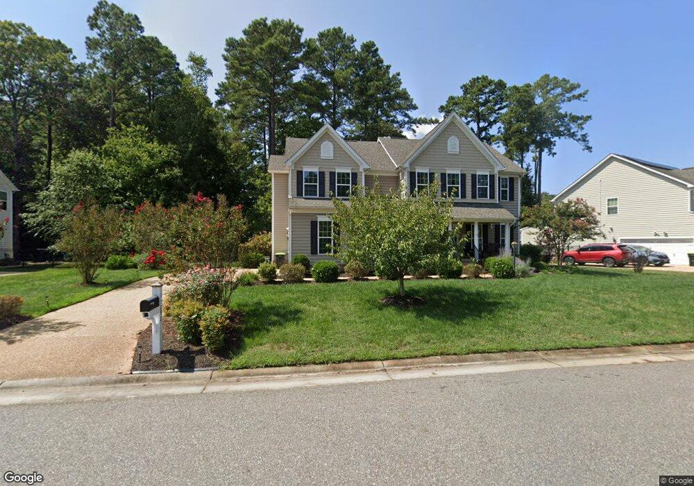
13292 Windsong Way Carrollton, VA 23314
Estimated Value: $543,795 - $562,000
5
Beds
4
Baths
2,935
Sq Ft
$188/Sq Ft
Est. Value
About This Home
This home is located at 13292 Windsong Way, Carrollton, VA 23314 and is currently estimated at $551,699, approximately $187 per square foot. 13292 Windsong Way is a home located in Isle of Wight County with nearby schools including Carrollton Elementary School, Smithfield Middle School, and Smithfield High School.
Ownership History
Date
Name
Owned For
Owner Type
Purchase Details
Closed on
May 31, 2022
Sold by
Dewitt Shane T
Bought by
Ponder Stanley D and Ponder Kareshia
Current Estimated Value
Home Financials for this Owner
Home Financials are based on the most recent Mortgage that was taken out on this home.
Original Mortgage
$498,700
Outstanding Balance
$473,112
Interest Rate
5.1%
Mortgage Type
VA
Estimated Equity
$78,587
Purchase Details
Closed on
Jan 25, 2016
Purchase Details
Closed on
Oct 14, 2015
Create a Home Valuation Report for This Property
The Home Valuation Report is an in-depth analysis detailing your home's value as well as a comparison with similar homes in the area
Home Values in the Area
Average Home Value in this Area
Purchase History
| Date | Buyer | Sale Price | Title Company |
|---|---|---|---|
| Ponder Stanley D | $485,000 | New Title Company Name | |
| -- | $390,900 | -- | |
| -- | $90,500 | -- |
Source: Public Records
Mortgage History
| Date | Status | Borrower | Loan Amount |
|---|---|---|---|
| Open | Ponder Stanley D | $498,700 |
Source: Public Records
Tax History Compared to Growth
Tax History
| Year | Tax Paid | Tax Assessment Tax Assessment Total Assessment is a certain percentage of the fair market value that is determined by local assessors to be the total taxable value of land and additions on the property. | Land | Improvement |
|---|---|---|---|---|
| 2025 | $3,773 | $486,900 | $120,000 | $366,900 |
| 2024 | $3,554 | $486,900 | $120,000 | $366,900 |
| 2023 | $3,511 | $486,900 | $120,000 | $366,900 |
| 2022 | $3,350 | $387,800 | $120,000 | $267,800 |
| 2021 | $3,350 | $387,800 | $120,000 | $267,800 |
| 2020 | $3,350 | $387,800 | $120,000 | $267,800 |
| 2019 | $3,350 | $387,800 | $120,000 | $267,800 |
| 2018 | $3,434 | $397,600 | $120,000 | $277,600 |
| 2016 | $3,452 | $397,600 | $120,000 | $277,600 |
| 2015 | -- | $120,000 | $120,000 | $0 |
Source: Public Records
Map
Nearby Homes
- 3.42AC Smiths Neck Rd
- 1105 Rivers Arch
- 22346 Tradewinds Dr
- 1002 Rivers Arch
- 902 Rivers Arch
- 1509 Broad Water Arch
- 101 Herons Cove
- 410 Marsh Hawk Trail
- 2002 James River Trail
- 1804 James River Trail
- 13389 Chesapeake Place
- 1608 James River Trail
- 1602 James River Trail
- Caroline Essential Plan at South Harbor - Towns 55 Plus
- Bramante Ranch Plan at South Harbor - Single-Family 55 Plus
- Bramante 2 Story Plan at South Harbor - Single-Family 55 Plus
- Palladio 2 Story Plan at South Harbor - Single-Family 55 Plus
- Palladio Ranch Plan at South Harbor - Single-Family 55 Plus
- 13032 Lighthouse Ln
- 13461 S Village Way
- 13284 Windsong Way
- 13300 Windsong Way
- 22301 Lake Forest Cir
- 13230 Beacon Hill Way
- 13276 Windsong Way
- 13308 Windsong Way
- 22308 Lake Forest Cir
- 13297 Windsong Way
- 13222 Beacon Hill Way
- 13313 Windsong Way
- 22309 Lake Forrest Cir
- 13289 Windsong Way
- 22309 Lake Forrest Cir
- 13214 Beacon Hill Way
- 13316 Windsong Way
- 13281 Windsong Way
- 13321 Windsong Way
- 22317 Lake Forrest Cir
- 22317 Lake Forrest Cir
- 13183 Beacon Hill Way