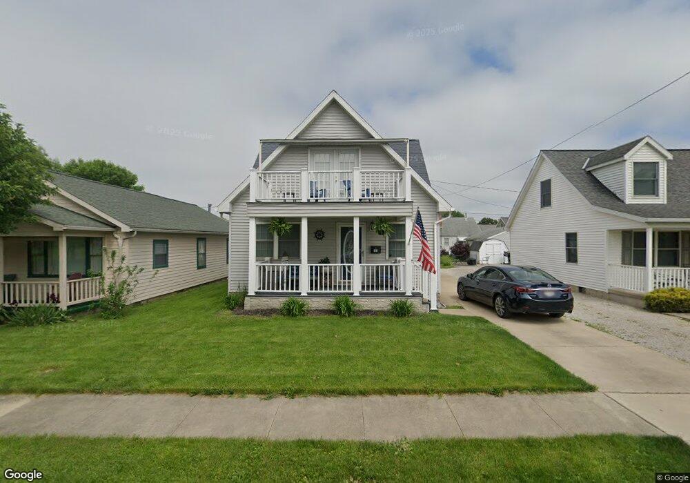
133 Cedar St Port Clinton, OH 43452
Estimated Value: $280,000 - $306,000
2
Beds
2
Baths
1,210
Sq Ft
$243/Sq Ft
Est. Value
About This Home
This home is located at 133 Cedar St, Port Clinton, OH 43452 and is currently estimated at $294,102, approximately $243 per square foot. 133 Cedar St is a home located in Ottawa County with nearby schools including Bataan Memorial Primary School, Bataan Memorial Intermediate School, and Port Clinton Middle School.
Ownership History
Date
Name
Owned For
Owner Type
Purchase Details
Closed on
May 27, 2021
Sold by
Cremean Erin
Bought by
Yost William F and Yost Faith L
Current Estimated Value
Home Financials for this Owner
Home Financials are based on the most recent Mortgage that was taken out on this home.
Original Mortgage
$184,000
Outstanding Balance
$166,589
Interest Rate
2.9%
Mortgage Type
New Conventional
Estimated Equity
$127,513
Purchase Details
Closed on
Sep 28, 2018
Sold by
Wenger Frederick S
Bought by
Cremean Erin
Home Financials for this Owner
Home Financials are based on the most recent Mortgage that was taken out on this home.
Original Mortgage
$151,515
Interest Rate
4.5%
Mortgage Type
New Conventional
Purchase Details
Closed on
Jan 8, 2009
Sold by
Wenger David R and Wenger Hailey Lynn
Bought by
Wenger Frederick S
Create a Home Valuation Report for This Property
The Home Valuation Report is an in-depth analysis detailing your home's value as well as a comparison with similar homes in the area
Home Values in the Area
Average Home Value in this Area
Purchase History
| Date | Buyer | Sale Price | Title Company |
|---|---|---|---|
| Yost William F | $230,000 | None Available | |
| Cremean Erin | $150,000 | None Available | |
| Wenger Frederick S | -- | Attorney |
Source: Public Records
Mortgage History
| Date | Status | Borrower | Loan Amount |
|---|---|---|---|
| Open | Yost William F | $184,000 | |
| Previous Owner | Cremean Erin | $151,515 |
Source: Public Records
Tax History Compared to Growth
Tax History
| Year | Tax Paid | Tax Assessment Tax Assessment Total Assessment is a certain percentage of the fair market value that is determined by local assessors to be the total taxable value of land and additions on the property. | Land | Improvement |
|---|---|---|---|---|
| 2024 | $2,820 | $81,365 | $16,758 | $64,607 |
| 2023 | $2,820 | $54,562 | $7,448 | $47,114 |
| 2022 | $2,116 | $54,562 | $7,448 | $47,114 |
| 2021 | $2,167 | $54,560 | $7,450 | $47,110 |
| 2020 | $1,569 | $41,280 | $5,320 | $35,960 |
| 2019 | $1,553 | $41,280 | $5,320 | $35,960 |
| 2018 | $1,190 | $41,280 | $5,320 | $35,960 |
| 2017 | $1,019 | $36,160 | $3,320 | $32,840 |
| 2016 | $1,021 | $36,160 | $3,320 | $32,840 |
| 2015 | $1,025 | $36,160 | $3,320 | $32,840 |
| 2014 | $487 | $34,550 | $3,320 | $31,230 |
| 2013 | $487 | $34,550 | $3,320 | $31,230 |
Source: Public Records
Map
Nearby Homes
- 116 Walnut St
- 214 Linden St
- 1201 E 3rd St
- 35 N Beach St
- 29 N Beach St
- 218 Elm St
- 801 E 3rd St
- 115 Driftwood Dr
- 164 Driftwood Dr
- 188 Driftwood Dr
- 183 Driftwood Dr
- 168 Morningside Dr
- 199 Morningside Dr
- 1801 E Perry St Unit 22
- 525 E 2nd St
- 521 E 2nd St
- 1807 E Perry St Unit 69
- 34 Grande Lake Dr Unit C
- 423 Fulton St
- 2321 E State Rd