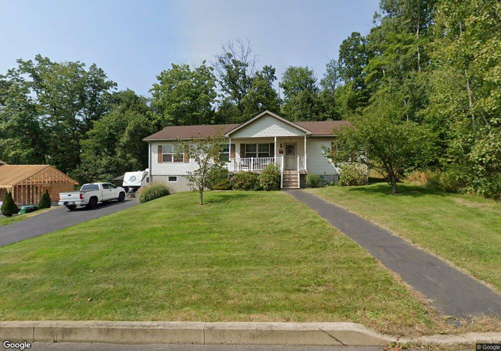
133 Chesterfield Ln Scranton, PA 18504
West Mountain NeighborhoodEstimated Value: $75,672 - $391,000
--
Bed
--
Bath
--
Sq Ft
9,975
Sq Ft Lot
About This Home
This home is located at 133 Chesterfield Ln, Scranton, PA 18504 and is currently estimated at $275,168. 133 Chesterfield Ln is a home located in Lackawanna County with nearby schools including Isaac Tripp Elementary School, West Scranton Intrmd School, and West Scranton High School.
Ownership History
Date
Name
Owned For
Owner Type
Purchase Details
Closed on
Mar 27, 2019
Sold by
Struckus Susan A and Struckus Stanley J
Bought by
Struckus Susan A and Struckus Stanley J
Current Estimated Value
Create a Home Valuation Report for This Property
The Home Valuation Report is an in-depth analysis detailing your home's value as well as a comparison with similar homes in the area
Home Values in the Area
Average Home Value in this Area
Purchase History
| Date | Buyer | Sale Price | Title Company |
|---|---|---|---|
| Struckus Susan A | -- | None Available |
Source: Public Records
Tax History Compared to Growth
Tax History
| Year | Tax Paid | Tax Assessment Tax Assessment Total Assessment is a certain percentage of the fair market value that is determined by local assessors to be the total taxable value of land and additions on the property. | Land | Improvement |
|---|---|---|---|---|
| 2025 | $7,234 | $20,100 | $7,100 | $13,000 |
| 2024 | $6,662 | $20,100 | $7,100 | $13,000 |
| 2023 | $6,662 | $20,100 | $7,100 | $13,000 |
| 2022 | $6,517 | $20,100 | $7,100 | $13,000 |
| 2021 | $6,517 | $20,100 | $7,100 | $13,000 |
| 2020 | $6,409 | $20,100 | $7,100 | $13,000 |
| 2019 | $6,045 | $20,100 | $7,100 | $13,000 |
| 2018 | $6,045 | $20,100 | $7,100 | $13,000 |
| 2017 | $5,950 | $20,100 | $7,100 | $13,000 |
| 2016 | $2,308 | $20,100 | $7,100 | $13,000 |
| 2015 | $4,276 | $20,100 | $7,100 | $13,000 |
| 2014 | -- | $20,100 | $7,100 | $13,000 |
Source: Public Records
Map
Nearby Homes
- 0 Roanoke Ln Unit GSBSC254856
- 0 Way
- 813 S Keyser Ave
- 0 Crisp Ave and Division St Unit 22-3646
- 138 S Keyser Ave
- 2613 Jackson St
- 2749 Jackson St
- 0 Marginal Rd Unit GSBSC253025
- 1924 Luzerne St
- 2133 35 Jackson St
- 1819 Luzerne St
- 2127 Price St
- 133 S Van Buren Ave
- 405 17th Ave
- 138-140 S Everett Ave
- 706 Parrott Ave
- 1809 Academy St
- 120 N Van Buren Ave
- 1809 Washburn St
- 2503 2505 Swetland St Unit L 2
- 118 Arlington Way
- Lot 74 Keyser Terrace Chesterfield Ln
- Lot #73 Keyser Terrace Roanoke Ln
- 0 Roanoke Ln Unit GSB18983
- 114 Arlington Way
- 119 Norfolk Way
- 107 Norfolk Way
- 417 Roanoke Ln
- 405 Roanoke Ln
- 115 Norfolk Way
- 122 Winchester Way
- 126 Winchester Way
- 118 Winchester Way
- 420 Roanoke Ln
- 414 Roanoke Ln
- 408 Roanoke Ln
- 113 Norfolk Way
- 118 Norfolk Way
- lot 66 Norfolk Way
- 105 Norfolk Way