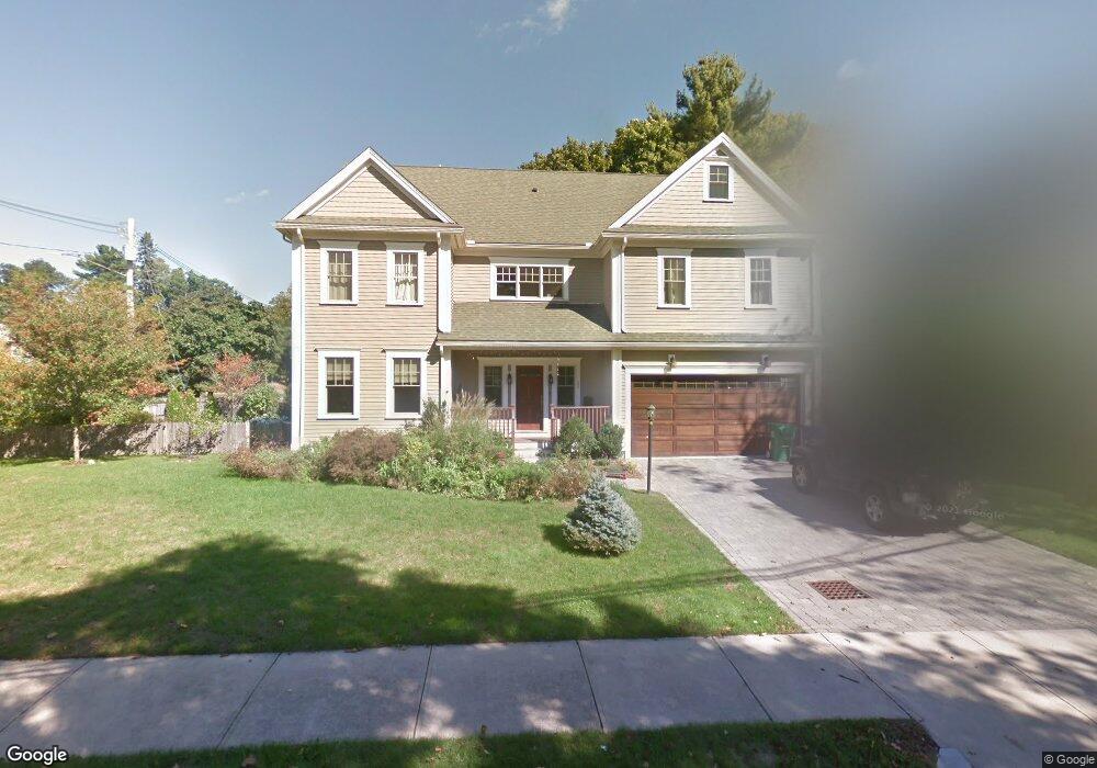
133 Hanson Rd Newton Center, MA 02459
Mount Ida NeighborhoodEstimated Value: $2,411,080 - $2,772,000
5
Beds
5
Baths
4,268
Sq Ft
$615/Sq Ft
Est. Value
About This Home
This home is located at 133 Hanson Rd, Newton Center, MA 02459 and is currently estimated at $2,626,520, approximately $615 per square foot. 133 Hanson Rd is a home located in Middlesex County with nearby schools including Memorial Spaulding Elementary School, Oak Hill Middle School, and Newton South High School.
Ownership History
Date
Name
Owned For
Owner Type
Purchase Details
Closed on
Dec 14, 2011
Sold by
Site & Structure Llc
Bought by
133 Hanson Road Rt and Gomberg Igor
Current Estimated Value
Purchase Details
Closed on
Jun 11, 2010
Sold by
Evans Sylvia M
Bought by
Site & Structure Llc and Needham Bk
Home Financials for this Owner
Home Financials are based on the most recent Mortgage that was taken out on this home.
Original Mortgage
$780,000
Interest Rate
5.11%
Mortgage Type
Purchase Money Mortgage
Create a Home Valuation Report for This Property
The Home Valuation Report is an in-depth analysis detailing your home's value as well as a comparison with similar homes in the area
Home Values in the Area
Average Home Value in this Area
Purchase History
| Date | Buyer | Sale Price | Title Company |
|---|---|---|---|
| 133 Hanson Road Rt | $1,300,000 | -- | |
| Site & Structure Llc | $400,000 | -- |
Source: Public Records
Mortgage History
| Date | Status | Borrower | Loan Amount |
|---|---|---|---|
| Previous Owner | Site & Structure Llc | $780,000 |
Source: Public Records
Tax History
| Year | Tax Paid | Tax Assessment Tax Assessment Total Assessment is a certain percentage of the fair market value that is determined by local assessors to be the total taxable value of land and additions on the property. | Land | Improvement |
|---|---|---|---|---|
| 2025 | $22,321 | $2,277,700 | $658,900 | $1,618,800 |
| 2024 | $21,583 | $2,211,400 | $639,700 | $1,571,700 |
| 2023 | $20,616 | $2,025,100 | $486,100 | $1,539,000 |
| 2022 | $19,726 | $1,875,100 | $450,100 | $1,425,000 |
| 2021 | $19,034 | $1,769,000 | $424,600 | $1,344,400 |
| 2020 | $18,468 | $1,769,000 | $424,600 | $1,344,400 |
| 2019 | $17,948 | $1,717,500 | $412,200 | $1,305,300 |
| 2018 | $17,327 | $1,601,400 | $374,100 | $1,227,300 |
| 2017 | $16,800 | $1,510,800 | $352,900 | $1,157,900 |
| 2016 | $16,069 | $1,412,000 | $329,800 | $1,082,200 |
| 2015 | $15,321 | $1,319,600 | $308,200 | $1,011,400 |
Source: Public Records
Map
Nearby Homes
- 90 Mccarthy Rd
- 17 Caldon Path
- 544 Saw Mill Brook Pkwy
- 30 K Roadway
- 25 Cavanaugh Path
- 36 Ober Rd
- 21 Lovett Rd
- 50 Lovett Rd
- 210 Nahanton St Unit 404
- 28 Cottonwood Rd
- 150 Country Club Rd
- 135 Hartman Rd
- 93 Sevland Rd
- 41 Juniper Ln
- 63 Drumlin Rd
- 17 Tirrell Crescent
- 931 Lagrange St
- 923 Lagrange St
- 58 Country Club Rd
- 16 Dorcar Rd
- 88 Wiswall Rd
- 88 Wiswall Rd Unit 4
- 127 Hanson Rd
- 134 Hanson Rd
- 134 Hanson Rd Unit 134
- 124 Mccarthy Rd
- 118 Mccarthy Rd
- 128 Hanson Rd
- 93 Wiswall Rd
- 119 Hanson Rd
- 103 Wiswall Rd
- 121 Hanson Rd
- 89 Wiswall Rd
- 110 Mccarthy Rd
- 118 Hanson Rd
- 120 Hanson Rd
- 81 Wiswall Rd
- 109 Wiswall Rd
- 118 Wiswall Rd
- 118 Wiswall Rd Unit 118