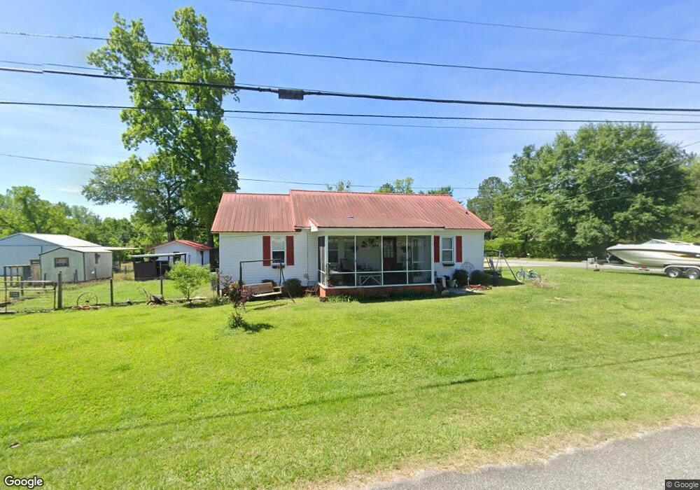
133 Jackson Ave W Whigham, GA 39897
Estimated Value: $145,000 - $207,000
3
Beds
1
Bath
1,589
Sq Ft
$107/Sq Ft
Est. Value
About This Home
This home is located at 133 Jackson Ave W, Whigham, GA 39897 and is currently estimated at $170,721, approximately $107 per square foot. 133 Jackson Ave W is a home.
Ownership History
Date
Name
Owned For
Owner Type
Purchase Details
Closed on
Mar 26, 2010
Sold by
Gainous David Trey
Bought by
Singletary Joel C and Singletary Emily M
Current Estimated Value
Home Financials for this Owner
Home Financials are based on the most recent Mortgage that was taken out on this home.
Original Mortgage
$86,734
Outstanding Balance
$57,825
Interest Rate
5.02%
Mortgage Type
New Conventional
Estimated Equity
$112,896
Purchase Details
Closed on
May 18, 2006
Sold by
Gainous Michael T
Bought by
Gainous David Trey
Home Financials for this Owner
Home Financials are based on the most recent Mortgage that was taken out on this home.
Original Mortgage
$79,373
Interest Rate
6.44%
Mortgage Type
New Conventional
Purchase Details
Closed on
Sep 28, 1989
Bought by
Gainous Michael T
Create a Home Valuation Report for This Property
The Home Valuation Report is an in-depth analysis detailing your home's value as well as a comparison with similar homes in the area
Home Values in the Area
Average Home Value in this Area
Purchase History
| Date | Buyer | Sale Price | Title Company |
|---|---|---|---|
| Singletary Joel C | $85,000 | -- | |
| Gainous David Trey | $80,000 | -- | |
| Gainous Michael T | $16,500 | -- |
Source: Public Records
Mortgage History
| Date | Status | Borrower | Loan Amount |
|---|---|---|---|
| Open | Singletary Joel C | $86,734 | |
| Previous Owner | Gainous David Trey | $79,373 |
Source: Public Records
Tax History Compared to Growth
Tax History
| Year | Tax Paid | Tax Assessment Tax Assessment Total Assessment is a certain percentage of the fair market value that is determined by local assessors to be the total taxable value of land and additions on the property. | Land | Improvement |
|---|---|---|---|---|
| 2024 | $2,164 | $60,959 | $2,000 | $58,959 |
| 2023 | $1,302 | $37,355 | $1,764 | $35,591 |
| 2022 | $1,302 | $37,355 | $1,764 | $35,591 |
| 2021 | $1,308 | $37,355 | $1,764 | $35,591 |
| 2020 | $1,060 | $30,497 | $1,764 | $28,733 |
| 2019 | $1,060 | $30,497 | $1,764 | $28,733 |
| 2018 | $1,006 | $30,497 | $1,764 | $28,733 |
| 2017 | $966 | $30,497 | $1,764 | $28,733 |
| 2016 | $843 | $26,337 | $1,764 | $24,573 |
| 2015 | $834 | $26,337 | $1,764 | $24,573 |
| 2014 | -- | $26,337 | $1,764 | $24,573 |
| 2013 | -- | $23,457 | $1,764 | $21,693 |
Source: Public Records
Map
Nearby Homes
- 165 Larkin St
- 206 Lodge Ln
- 267 Providence Rd
- 723 Providence Rd
- 1718 Old 179 S
- 231 Mcintyre Ln
- 2033 Old 179 N
- 0 Upper Hawthorne Trail
- 1137 Summerfield
- 1520 Upper Hawthorne Trail
- 3695 Tired Creek Rd
- 00 Tired Creek Rd
- 1389 Lake Front Dr
- 0 Earl Hester Rd
- Lot 1 Crine Blvd
- 1500 15th Ave NW
- 316 Faircloth Rd
- 490 13th St SW
- 1296 McQuaig St NW
- 292 Sykes Mill Rd