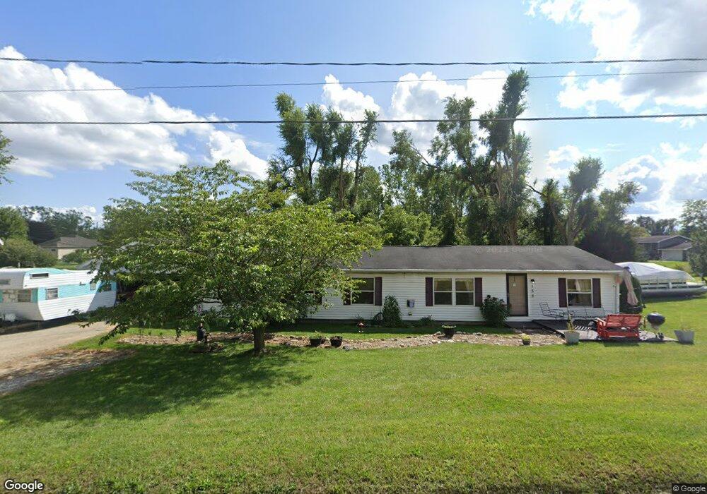
133 Kathy Ln Brooklyn, MI 49230
Estimated Value: $299,636 - $344,000
2
Beds
2
Baths
2,110
Sq Ft
$151/Sq Ft
Est. Value
About This Home
This home is located at 133 Kathy Ln, Brooklyn, MI 49230 and is currently estimated at $318,159, approximately $150 per square foot. 133 Kathy Ln is a home located in Jackson County with nearby schools including Columbia Lower Elementary School, Columbia Upper Elementary School, and Columbia Central Jr./Sr. High School.
Ownership History
Date
Name
Owned For
Owner Type
Purchase Details
Closed on
Apr 25, 2005
Sold by
Tant Kathleen E and Sisson Kathleen
Bought by
Lavasseur Dale R and Lavasseur Tammy J
Current Estimated Value
Home Financials for this Owner
Home Financials are based on the most recent Mortgage that was taken out on this home.
Original Mortgage
$124,600
Interest Rate
6.05%
Mortgage Type
Fannie Mae Freddie Mac
Create a Home Valuation Report for This Property
The Home Valuation Report is an in-depth analysis detailing your home's value as well as a comparison with similar homes in the area
Home Values in the Area
Average Home Value in this Area
Purchase History
| Date | Buyer | Sale Price | Title Company |
|---|---|---|---|
| Lavasseur Dale R | $10,500 | At |
Source: Public Records
Mortgage History
| Date | Status | Borrower | Loan Amount |
|---|---|---|---|
| Closed | Lavasseur Dale R | $124,600 |
Source: Public Records
Tax History Compared to Growth
Tax History
| Year | Tax Paid | Tax Assessment Tax Assessment Total Assessment is a certain percentage of the fair market value that is determined by local assessors to be the total taxable value of land and additions on the property. | Land | Improvement |
|---|---|---|---|---|
| 2025 | $1,811 | $134,100 | $0 | $0 |
| 2024 | $1,187 | $127,500 | $0 | $0 |
| 2023 | $1,131 | $116,600 | $0 | $0 |
| 2022 | $2,099 | $100,700 | $0 | $0 |
| 2021 | $2,094 | $96,200 | $0 | $0 |
| 2020 | $2,092 | $94,400 | $0 | $0 |
| 2019 | $2,069 | $78,500 | $0 | $0 |
| 2018 | $2,049 | $71,600 | $0 | $0 |
| 2017 | $1,986 | $69,600 | $0 | $0 |
| 2016 | $981 | $68,800 | $68,800 | $0 |
| 2015 | $1,967 | $63,600 | $63,600 | $0 |
| 2014 | $1,967 | $60,200 | $60,200 | $0 |
| 2013 | -- | $60,200 | $60,200 | $0 |
Source: Public Records
Map
Nearby Homes
- 129 Kathy Ln
- 120 Kathy Ln
- 12975 Hayes Rd
- 287 Somerset Dr
- 12938 Kelley Rd
- 125 W Princess Dr
- 126 E Princess Dr
- 104 High View Ct
- 407 Potter St
- 319 Neil St
- 107 Bennington Ln
- 110 Littlefield Ln
- 506 Lewis Rd
- 6416 Kelley Rd
- 15255 Wheaton Rd
- 227 Riviera Dr
- 6977 Cement City Rd
- 320 Nottingham Dr
- 215 Nottingham Dr
- 200 Barbara Dr
- 133 Decatur Dr
- 133 Decatur Dr Unit Lot 7 Royal Shores
- 134 Kathy Ln
- 136 Decatur Dr
- 136 Decatur Dr Unit 134 Decatur
- 129 Kathy Ln
- 135 Decatur Dr
- 130 Kathy Ln
- 130 Kathy Ln Unit KATHY
- 0 Flint Dr Unit 201601517
- 0 Flint Dr Unit 55021083815
- 0 Flint Dr Unit 62022050100
- 0 Flint Dr Unit 22050100
- 0 Flint Dr Unit 20221021195
- 0 Flint Dr Unit 2220030029
- 0 Flint Dr Unit M21083815
- 119 Decatur Dr
- 119 Decatur Dr
- 109 Flint Dr
- 16486 Cement City Rd