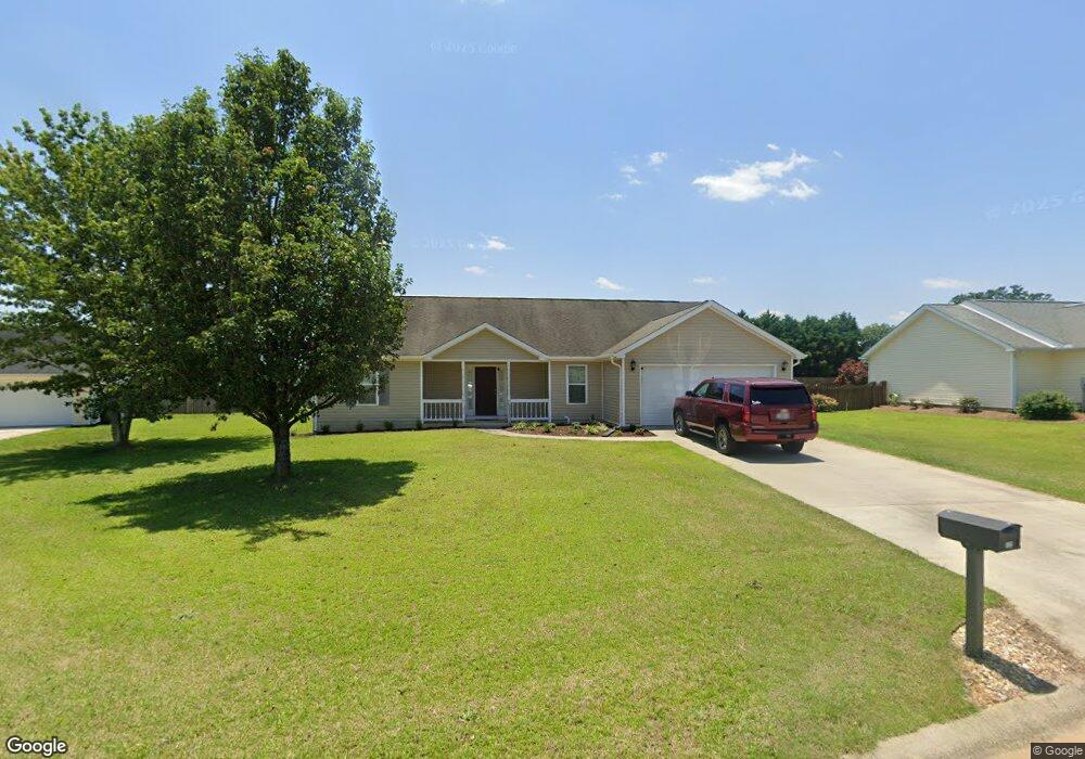
133 Lonesome Doe Cir Kathleen, GA 31047
Estimated Value: $227,000 - $244,000
3
Beds
2
Baths
1,534
Sq Ft
$155/Sq Ft
Est. Value
About This Home
This home is located at 133 Lonesome Doe Cir, Kathleen, GA 31047 and is currently estimated at $237,279, approximately $154 per square foot. 133 Lonesome Doe Cir is a home located in Houston County with nearby schools including Matthew Arthur Elementary School, Perry Middle School, and Veterans High School.
Ownership History
Date
Name
Owned For
Owner Type
Purchase Details
Closed on
May 19, 2006
Sold by
Smith William E
Bought by
Simpson James B
Current Estimated Value
Home Financials for this Owner
Home Financials are based on the most recent Mortgage that was taken out on this home.
Original Mortgage
$128,490
Outstanding Balance
$74,459
Interest Rate
6.41%
Mortgage Type
New Conventional
Estimated Equity
$162,820
Create a Home Valuation Report for This Property
The Home Valuation Report is an in-depth analysis detailing your home's value as well as a comparison with similar homes in the area
Home Values in the Area
Average Home Value in this Area
Purchase History
| Date | Buyer | Sale Price | Title Company |
|---|---|---|---|
| Simpson James B | $128,500 | None Available | |
| Smith William E | $16,800 | None Available |
Source: Public Records
Mortgage History
| Date | Status | Borrower | Loan Amount |
|---|---|---|---|
| Open | Smith William E | $128,490 |
Source: Public Records
Tax History Compared to Growth
Tax History
| Year | Tax Paid | Tax Assessment Tax Assessment Total Assessment is a certain percentage of the fair market value that is determined by local assessors to be the total taxable value of land and additions on the property. | Land | Improvement |
|---|---|---|---|---|
| 2024 | $1,713 | $71,600 | $12,000 | $59,600 |
| 2023 | $1,385 | $57,320 | $12,000 | $45,320 |
| 2022 | $1,325 | $54,840 | $12,000 | $42,840 |
| 2021 | $1,218 | $50,120 | $12,000 | $38,120 |
| 2020 | $1,217 | $49,840 | $12,000 | $37,840 |
| 2019 | $1,217 | $49,840 | $12,000 | $37,840 |
| 2018 | $1,217 | $49,840 | $12,000 | $37,840 |
| 2017 | $1,218 | $49,840 | $12,000 | $37,840 |
| 2016 | $1,220 | $49,840 | $12,000 | $37,840 |
| 2015 | $1,222 | $49,840 | $12,000 | $37,840 |
| 2014 | -- | $49,840 | $12,000 | $37,840 |
| 2013 | -- | $49,840 | $12,000 | $37,840 |
Source: Public Records
Map
Nearby Homes
- 106 Planter's Ridge Trail
- 238 Old Hollow Way
- 531 Bristleleaf Path
- 529 Bristleleaf Path
- 521 Bristleleaf Path
- 202 Emberwood Way
- 525 Bristleleaf Path
- 533 Bristleleaf Path
- 315 Willowbrook Ln
- 523 Bristleleaf Path
- 109 Black Birch Ln
- 205 Emberwood Way
- 101 Black Birch Ln
- 102 Black Birch Ln
- 321 Willowbrook Ln
- 105 Black Birch Ln
- 313 Willowbrook Ln
- 319 Willowbrook Run
- 323 Willowbrook Ln
- 605 Bristleleaf Path
- 135 Lonesome Doe Cir
- 131 Lonesome Doe Cir
- 103 Wilderness Trail
- 129 Lonesome Doe Cir
- 105 Wilderness Trail
- 116 Lonesome Doe Cir
- 137 Lonesome Doe Cir
- 118 Lonesome Doe Cir
- 127 Lonesome Doe Cir
- 101 Wilderness Trail
- 120 Lonesome Doe Cir
- 125 Lonesome Doe Cir
- 125 Lonesome Doe Cir
- 107 Wilderness Trail
- 0 Wilderness Trail
- 124 Field View Ln
- 115 Rolling Meadow Way
- 109 Rolling Meadow Way Unit LOT 483
- 105 Rolling Meadow Way
- 104 Moss Wood Ct