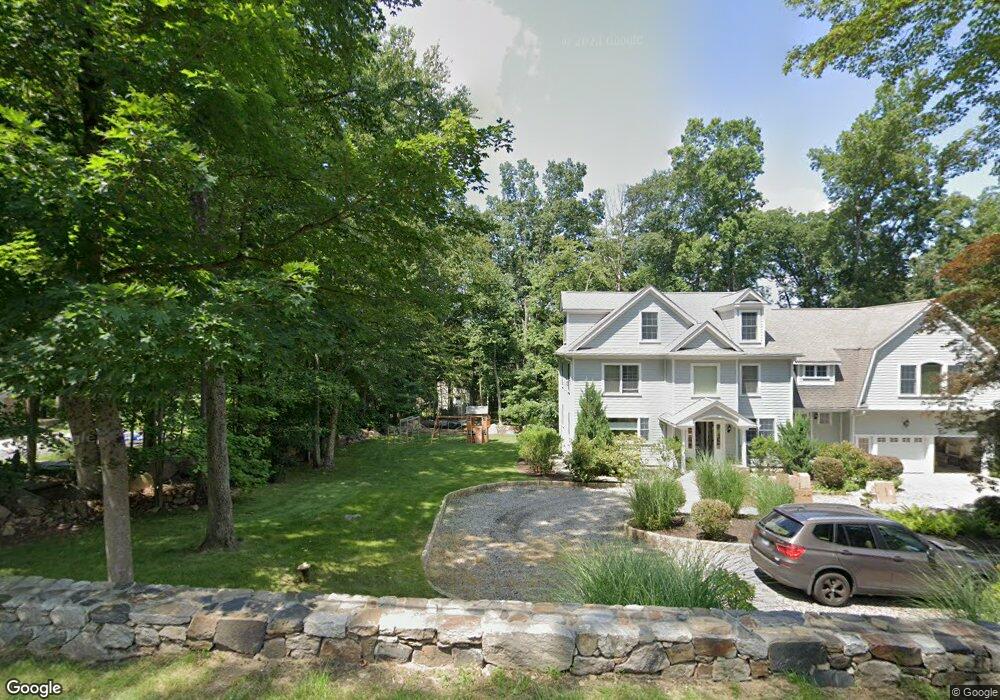
133 New Rd Ridgefield, CT 06877
Estimated Value: $1,737,178 - $1,967,000
4
Beds
4
Baths
3,723
Sq Ft
$493/Sq Ft
Est. Value
About This Home
This home is located at 133 New Rd, Ridgefield, CT 06877 and is currently estimated at $1,837,045, approximately $493 per square foot. 133 New Rd is a home located in Fairfield County with nearby schools including Farmingville Elementary School, Ridgefield High School, and Ridgefield Montessori School.
Ownership History
Date
Name
Owned For
Owner Type
Purchase Details
Closed on
Jul 16, 2002
Sold by
Petiford David E and Petiford Laura E
Bought by
Weir Michael F and Weir Maureen P
Current Estimated Value
Purchase Details
Closed on
Sep 16, 1998
Sold by
M Mannion Homes Llc
Bought by
Petiford David E and Petiford Laura E
Create a Home Valuation Report for This Property
The Home Valuation Report is an in-depth analysis detailing your home's value as well as a comparison with similar homes in the area
Home Values in the Area
Average Home Value in this Area
Purchase History
| Date | Buyer | Sale Price | Title Company |
|---|---|---|---|
| Weir Michael F | $1,039,000 | -- | |
| Petiford David E | $681,419 | -- |
Source: Public Records
Mortgage History
| Date | Status | Borrower | Loan Amount |
|---|---|---|---|
| Open | Petiford David E | $177,000 | |
| Open | Petiford David E | $643,000 | |
| Closed | Petiford David E | $577,690 | |
| Closed | Petiford David E | $550,000 |
Source: Public Records
Tax History
| Year | Tax Paid | Tax Assessment Tax Assessment Total Assessment is a certain percentage of the fair market value that is determined by local assessors to be the total taxable value of land and additions on the property. | Land | Improvement |
|---|---|---|---|---|
| 2025 | $22,703 | $828,870 | $267,120 | $561,750 |
| 2024 | $21,841 | $828,870 | $267,120 | $561,750 |
| 2023 | $18,632 | $721,910 | $265,580 | $456,330 |
| 2022 | $19,060 | $670,410 | $213,060 | $457,350 |
| 2021 | $18,912 | $670,410 | $213,060 | $457,350 |
| 2020 | $18,852 | $670,410 | $213,060 | $457,350 |
| 2019 | $18,852 | $670,410 | $213,060 | $457,350 |
| 2018 | $18,624 | $670,410 | $213,060 | $457,350 |
| 2017 | $17,760 | $652,690 | $218,660 | $434,030 |
| 2016 | $17,420 | $652,690 | $218,660 | $434,030 |
| 2015 | $16,976 | $652,690 | $218,660 | $434,030 |
| 2014 | $16,976 | $652,690 | $218,660 | $434,030 |
Source: Public Records
Map
Nearby Homes
- 8 Cornerstone Ct
- 14 Fillmore Ln
- 176 Picketts Ridge Rd
- 12 Werf Dr
- 2 Lemon Ln
- 71 Picketts Ridge Rd
- 217 Danbury Rd
- 9 Dowling Dr
- 86 Starrs Plain Rd
- 15 Lookout Dr
- 77 Sunset Ln Unit 213
- 77 Sunset Ln Unit 223
- 19 Prospect Ridge Unit 14
- 151 North St
- 55 Olcott Way
- 59 Prospect St Unit C
- 32 Lawson Ln
- 20 Rita Rd
- 75 Lawson Ln
- 8 Stebbins Close Unit 8
- 135 New Rd
- 131 New Rd
- 123 New Rd
- 129 New Rd
- 119 New Rd
- 31 Lost Mine Place
- 99 New Rd
- 111 Fulling Mill Ln
- 33 Lost Mine Place
- 139 New Rd
- 42 Rolling Hills Rd
- 108 Fulling Mill Ln
- 19 Lost Mine Place
- 101 Fulling Mill Ln
- 27 Lost Mine Place
- 9 Palmer Ct
- 91 New Rd
- 114 Fulling Mill Ln
- 11 Lost Mine Place
- 100 Fulling Mill Ln
Your Personal Tour Guide
Ask me questions while you tour the home.