
Seller's Agent in 2026
Dallas Ducote
RE/MAX
(828) 243-8132
7 in this area
204 Total Sales
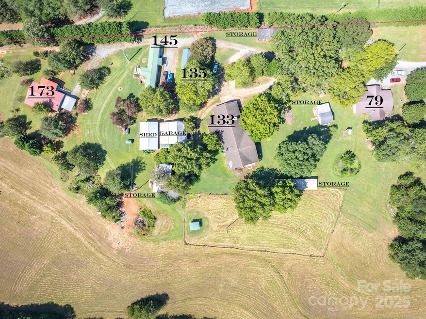
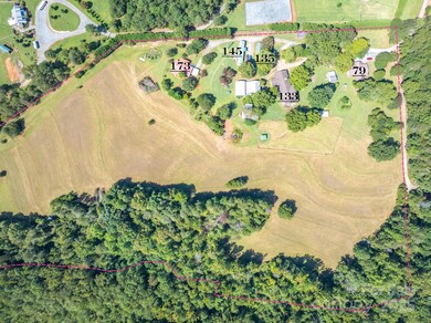
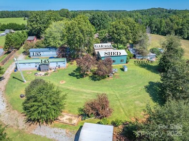
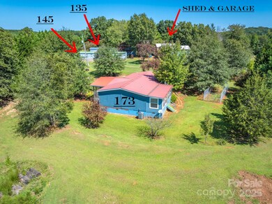
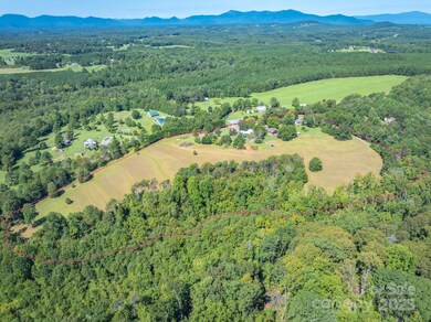
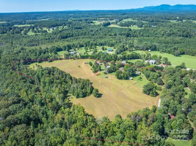
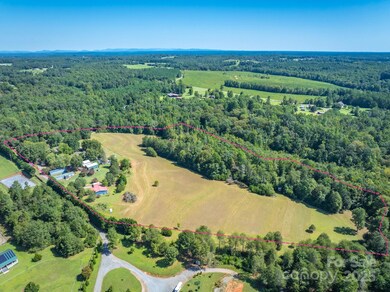
Now offering 19.8 acres in Columbus, NC featuring five dwellings on a single parcel—an excellent opportunity for investors or those looking to expand their rental portfolio. The main residence, located at 133 Pheasant Lane, is a spacious site-built home with 4 bedrooms, 3 bathrooms, a walkout basement, and approximately 5,139 square feet of living space. At 173 Pheasant Lane, you’ll find a 3-bedroom, 2-bath manufactured home with 1,316 heated square feet and both front and rear covered porches. Another site-built home at 79 Pheasant Lane includes 3 bedrooms, 1 bathroom, 1,494 square feet, and also features covered front and back porches. Located at 145 Pheasant Lane is a 2-bedroom, 1-bath single-wide manufactured home with 720 square feet. Lastly, 135 Pheasant Lane is a 3-bedroom, 2-bath single-wide manufactured home that is currently be rented. All homes are served by wells, septic systems, overhead power, and wired internet. Approximately 9 acres of the property remain open, mostly level, cleared, and easily accessible—ideal for future development. With no deed restrictions and no county zoning regulations, this land offers incredible flexibility, including potential for establishing a mobile home park or additional housing units. Buyers are encouraged to contact Polk County Planning and Zoning for more information regarding development possibilities.
Last Agent to Sell the Property
RE/MAX Results Brokerage Email: dpg.remax@gmail.com License #299370 Listed on: 09/15/2025
| Date | Type | Sale Price | Title Company |
|---|---|---|---|
| Warranty Deed | $1,000,000 | None Listed On Document | |
| Warranty Deed | $22,000 | None Listed On Document | |
| Warranty Deed | $13,500 | None Listed On Document | |
| Warranty Deed | $235,000 | None Available | |
| Warranty Deed | -- | None Available | |
| Deed | -- | -- |
| Date | Status | Loan Amount | Loan Type |
|---|---|---|---|
| Previous Owner | $188,750 | Future Advance Clause Open End Mortgage |
| Date | Event | Price | List to Sale | Price per Sq Ft |
|---|---|---|---|---|
| 02/13/2026 02/13/26 | Sold | $1,000,000 | -4.7% | $144 / Sq Ft |
| 09/15/2025 09/15/25 | For Sale | $1,049,000 | -- | $151 / Sq Ft |
| Year | Tax Paid | Tax Assessment Tax Assessment Total Assessment is a certain percentage of the fair market value that is determined by local assessors to be the total taxable value of land and additions on the property. | Land | Improvement |
|---|---|---|---|---|
| 2025 | $5,000 | $940,942 | $317,970 | $622,972 |
| 2024 | $4,314 | $665,472 | $227,400 | $438,072 |
| 2023 | $4,247 | $665,472 | $227,400 | $438,072 |
| 2022 | $3,387 | $730,172 | $292,100 | $438,072 |
| 2021 | $3,278 | $730,172 | $292,100 | $438,072 |
| 2020 | $3,187 | $642,828 | $309,100 | $333,728 |
| 2019 | $3,257 | $642,828 | $309,100 | $333,728 |
| 2018 | $3,350 | $641,464 | $309,100 | $332,364 |
| 2017 | $3,442 | $552,604 | $192,400 | $360,204 |
| 2016 | $2,670 | $552,604 | $192,400 | $360,204 |
| 2015 | $2,472 | $0 | $0 | $0 |
| 2014 | $2,472 | $0 | $0 | $0 |
| 2013 | -- | $0 | $0 | $0 |
Seller's Agent in 2026
Dallas Ducote
RE/MAX
(828) 243-8132
7 in this area
204 Total Sales
L
Buyer's Agent in 2026
Laura Peek
Gasperson-Peek Realty
(828) 777-4197
26 in this area
50 Total Sales
Source: Canopy MLS (Canopy Realtor® Association)
MLS Number: 4302775
APN: P109-4
Disclaimer: Certain information contained herein is derived from information provided by parties other than Homes.com. All information provided is deemed reliable, but is not guaranteed to be accurate and should be independently verified.
![]() All data is obtained from various sources and may not have been verified by broker or MLS GRID. Supplied Open House Information is subject to change without notice. All information should be independently reviewed and verified for accuracy. Properties may or may not be listed by the office/agent presenting the information. Some IDX listings have been excluded from this website.
All data is obtained from various sources and may not have been verified by broker or MLS GRID. Supplied Open House Information is subject to change without notice. All information should be independently reviewed and verified for accuracy. Properties may or may not be listed by the office/agent presenting the information. Some IDX listings have been excluded from this website.
Based on information submitted to the MLS GRID
Ask me questions while you tour the home.