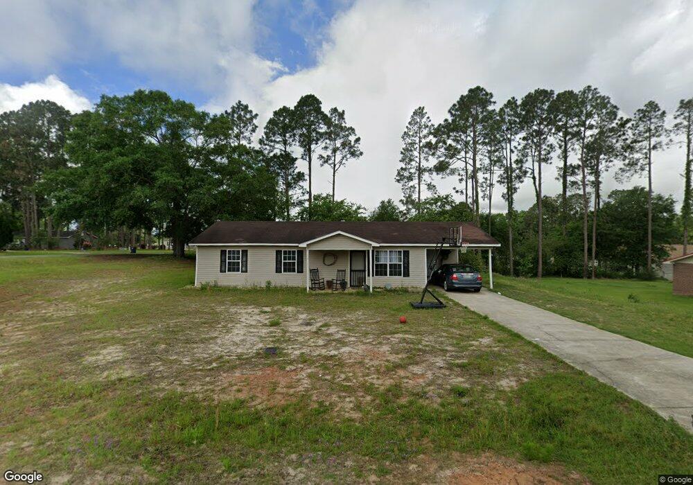
133 Red Maple Cir Moultrie, GA 31768
Estimated Value: $145,986 - $209,000
Studio
2
Baths
1,092
Sq Ft
$158/Sq Ft
Est. Value
About This Home
This home is located at 133 Red Maple Cir, Moultrie, GA 31768 and is currently estimated at $172,997, approximately $158 per square foot. 133 Red Maple Cir is a home located in Colquitt County with nearby schools including Funston Elementary School, C.A. Gray Junior High School, and Willie J. Williams Middle School.
Ownership History
Date
Name
Owned For
Owner Type
Purchase Details
Closed on
Feb 10, 2015
Sold by
Bell Robert K
Bought by
Greene Robert W
Current Estimated Value
Purchase Details
Closed on
Aug 20, 2014
Sold by
United States Of America
Bought by
Greene Robert W and Greene Judy G
Purchase Details
Closed on
Jun 3, 2014
Sold by
United States Of America
Bought by
Bell Robert K
Purchase Details
Closed on
Aug 6, 2013
Sold by
United States Of America A
Bought by
United States Of America
Purchase Details
Closed on
Mar 11, 1998
Bought by
Bryant Janice R
Purchase Details
Closed on
Feb 8, 1982
Bought by
Jones Lynn L
Create a Home Valuation Report for This Property
The Home Valuation Report is an in-depth analysis detailing your home's value as well as a comparison with similar homes in the area
Purchase History
| Date | Buyer | Sale Price | Title Company |
|---|---|---|---|
| Greene Robert W | -- | -- | |
| Greene Robert W | $33,300 | -- | |
| Bell Robert K | $9,000 | -- | |
| United States Of America | $24,005 | -- | |
| Bryant Janice R | $6,500 | -- | |
| Jones Lynn L | $23,400 | -- |
Source: Public Records
Tax History
| Year | Tax Paid | Tax Assessment Tax Assessment Total Assessment is a certain percentage of the fair market value that is determined by local assessors to be the total taxable value of land and additions on the property. | Land | Improvement |
|---|---|---|---|---|
| 2025 | $1,470 | $65,436 | $3,200 | $62,236 |
| 2024 | $1,470 | $50,082 | $3,200 | $46,882 |
| 2023 | $1,177 | $41,304 | $3,200 | $38,104 |
| 2022 | $907 | $34,108 | $3,200 | $30,908 |
| 2021 | $817 | $30,259 | $3,200 | $27,059 |
| 2020 | $771 | $27,970 | $3,200 | $24,770 |
| 2019 | $808 | $26,596 | $3,200 | $23,396 |
| 2018 | $801 | $26,596 | $3,200 | $23,396 |
| 2017 | $794 | $26,596 | $3,200 | $23,396 |
| 2016 | $799 | $26,596 | $3,200 | $23,396 |
| 2015 | $802 | $26,596 | $3,200 | $23,396 |
| 2014 | $299 | $25,959 | $3,200 | $22,759 |
| 2013 | -- | $25,959 | $3,200 | $22,759 |
Source: Public Records
Map
Nearby Homes
- 827 Bonnie Tuk Rd
- Lot 45 Fox Trot Dr
- LOT 52 Fox Trot Dr
- LOT 58 Fox Trot Dr
- LOT 56 Fox Trot Dr
- LOT 54 Fox Trot Dr
- 0 Fox Trot Dr
- LOT 53 Fox Trot Dr
- LOT 55 Fox Trot Dr
- 176 Fox Trot Dr
- LOT 29 Merganser Ln
- LOT 32 Merganser Ln
- LOT 28 Merganser Ln
- LOT 26 Merganser Ln
- LOT 30 Merganser Ln
- LOT 39 Westwoods Dr
- LOT 1 Westwoods Dr
- LOT 23 Westwoods Dr
- LOT 35 Westwoods Dr
- LOT 36 Westwoods Dr
- 143 Red Maple Cir
- 377 Oak Ln
- 369 Oak Ln
- 118 Pineridge St
- lot 3 Pineridge St
- 359 Oak Ln
- 152 Pineridge St NW
- 131 Pineridge St
- 378 W Mulberry St
- 141 Pineridge St
- 160 Pineridge St
- 368 W Mulberry St
- 386 W Mulberry St
- 353 Oak Ln
- 149 Pineridge St
- 358 W Mulberry St
- 138 Pineridge St
- 167 Red Maple Cir
- 166 Pineridge St
- 346 Oak Ln
Your Personal Tour Guide
Ask me questions while you tour the home.