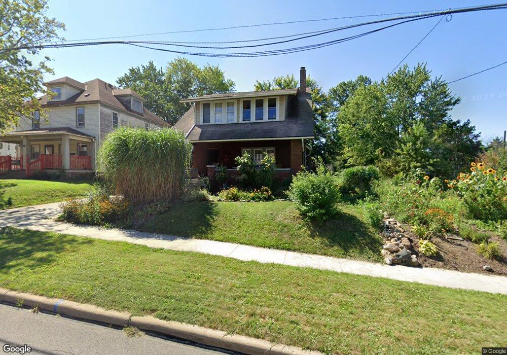
133 Rowland Ave Mansfield, OH 44903
Estimated Value: $79,000 - $118,834
3
Beds
2
Baths
1,868
Sq Ft
$54/Sq Ft
Est. Value
About This Home
This home is located at 133 Rowland Ave, Mansfield, OH 44903 and is currently estimated at $100,209, approximately $53 per square foot. 133 Rowland Ave is a home located in Richland County with nearby schools including Goal Digital Academy, Mansfield Elective Academy, and Interactive Media & Construction (IMAC) Academy.
Ownership History
Date
Name
Owned For
Owner Type
Purchase Details
Closed on
Mar 2, 2021
Sold by
Stanfield Matthew N and Stanfield Amanda K
Bought by
Stanfield Matthew N and Stanfield Amanda K
Current Estimated Value
Purchase Details
Closed on
Feb 1, 2000
Sold by
Est Robert F Zaebst
Bought by
Stanfield Matthew N and Stanfield Amanda K
Home Financials for this Owner
Home Financials are based on the most recent Mortgage that was taken out on this home.
Original Mortgage
$42,250
Interest Rate
7.84%
Mortgage Type
FHA
Create a Home Valuation Report for This Property
The Home Valuation Report is an in-depth analysis detailing your home's value as well as a comparison with similar homes in the area
Home Values in the Area
Average Home Value in this Area
Purchase History
| Date | Buyer | Sale Price | Title Company |
|---|---|---|---|
| Stanfield Matthew N | -- | None Listed On Document | |
| Stanfield Matthew N | -- | None Listed On Document | |
| Stanfield Matthew N | $42,125 | -- |
Source: Public Records
Mortgage History
| Date | Status | Borrower | Loan Amount |
|---|---|---|---|
| Previous Owner | Stanfield Matthew N | $42,250 |
Source: Public Records
Tax History Compared to Growth
Tax History
| Year | Tax Paid | Tax Assessment Tax Assessment Total Assessment is a certain percentage of the fair market value that is determined by local assessors to be the total taxable value of land and additions on the property. | Land | Improvement |
|---|---|---|---|---|
| 2024 | $969 | $20,700 | $14,050 | $6,650 |
| 2023 | $969 | $20,700 | $14,050 | $6,650 |
| 2022 | $1,060 | $18,980 | $13,590 | $5,390 |
| 2021 | $1,068 | $18,980 | $13,590 | $5,390 |
| 2020 | $422 | $7,330 | $1,940 | $5,390 |
| 2019 | $467 | $7,330 | $1,940 | $5,390 |
| 2018 | $461 | $7,330 | $1,940 | $5,390 |
| 2017 | $904 | $14,780 | $1,940 | $12,840 |
| 2016 | $1,083 | $17,160 | $4,280 | $12,880 |
| 2015 | $1,034 | $17,160 | $4,280 | $12,880 |
| 2014 | $1,021 | $17,160 | $4,280 | $12,880 |
| 2012 | $389 | $17,160 | $4,500 | $12,660 |
Source: Public Records
Map
Nearby Homes
- 96 Helen Ave
- 120 Gettings Place
- 80 Rowland Ave
- 116 Penn Ave
- 406 Sherman Place
- 237 Helen Ave
- 132 Sycamore St
- 38 Baldwin Ave
- 24 Stewart Ave S
- 611 Park Ave W
- 37 Baldwin Ave
- 21 Glenwood Blvd
- 76 Bartley Ave
- 88 Sherman Ave
- 41 Parkwood Blvd
- 71 Glenwood Blvd
- 126 Dawson Ave
- 114 Vennum Ave
- 118 Lind Ave
- 219 W 5th St
- 139 Rowland Ave
- 129 Rowland Ave
- 0 Rowland Ave
- 125 Rowland Ave
- 517 W 4th St
- 142 Rowland Ave
- 136 Rowland Ave
- 521 Crowell Dr
- 501 W 4th St
- 521 W 4th St
- 516 Heineman Blvd
- 512 Heineman Blvd
- 497 W 4th St
- 117 Rowland Ave
- 132 Rowland Ave
- 142 Helen Ave
- 132 Helen Ave Unit 134
- 527 W 4th St
- 128 Helen Ave
- 148 Helen Ave