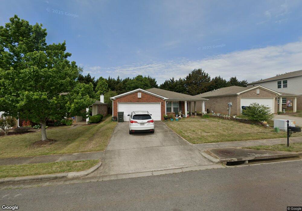
133 Sagebrook Dr Madison, AL 35757
Monrovia NeighborhoodEstimated Value: $233,491 - $257,000
Studio
--
Bath
1,618
Sq Ft
$155/Sq Ft
Est. Value
About This Home
This home is located at 133 Sagebrook Dr, Madison, AL 35757 and is currently estimated at $250,373, approximately $154 per square foot. 133 Sagebrook Dr is a home with nearby schools including Legacy Elementary School, Monrovia Middle School, and Sparkman High School.
Ownership History
Date
Name
Owned For
Owner Type
Purchase Details
Closed on
Nov 17, 2008
Sold by
Hunter Communities Inc
Bought by
Wisniewski Stanley W and Wisniewski Deborah R
Current Estimated Value
Home Financials for this Owner
Home Financials are based on the most recent Mortgage that was taken out on this home.
Original Mortgage
$99,900
Outstanding Balance
$65,129
Interest Rate
6.11%
Mortgage Type
New Conventional
Estimated Equity
$185,244
Create a Home Valuation Report for This Property
The Home Valuation Report is an in-depth analysis detailing your home's value as well as a comparison with similar homes in the area
Home Values in the Area
Average Home Value in this Area
Purchase History
| Date | Buyer | Sale Price | Title Company |
|---|---|---|---|
| Wisniewski Stanley W | -- | None Available | |
| Wisniewski Stanley W | -- | -- |
Source: Public Records
Mortgage History
| Date | Status | Borrower | Loan Amount |
|---|---|---|---|
| Open | Wisniewski Stanley W | $99,900 | |
| Closed | Wisniewski Stanley W | $99,900 |
Source: Public Records
Tax History
| Year | Tax Paid | Tax Assessment Tax Assessment Total Assessment is a certain percentage of the fair market value that is determined by local assessors to be the total taxable value of land and additions on the property. | Land | Improvement |
|---|---|---|---|---|
| 2025 | $590 | $20,860 | $4,640 | $16,220 |
| 2024 | $590 | $19,500 | $5,000 | $14,500 |
| 2023 | $548 | $19,500 | $5,000 | $14,500 |
| 2022 | $461 | $16,460 | $3,500 | $12,960 |
| 2021 | $360 | $12,980 | $2,500 | $10,480 |
| 2020 | $362 | $13,030 | $2,500 | $10,530 |
| 2019 | $362 | $13,030 | $2,500 | $10,530 |
| 2018 | $344 | $12,440 | $0 | $0 |
| 2017 | $344 | $12,440 | $0 | $0 |
| 2016 | $359 | $12,960 | $0 | $0 |
| 2015 | $359 | $12,960 | $0 | $0 |
| 2014 | $367 | $13,200 | $0 | $0 |
Source: Public Records
Map
Nearby Homes
- 111 Sagebrook Dr
- 150 Sagebrook Dr
- 365 Weatherford Dr NW
- 509 Summer Cove Cir NW
- 160 Forestbrook Dr
- 482 Mount Zion Rd
- 519 Summer Cove Cir NW
- 326 Weatherford Dr NW
- 236 Nettles Dr NW
- 622 Summer Cove Cir NW
- 110 High Green Dr
- 108 Conifer Ct
- 236 Crab Orchard Dr
- 212 Miniver Place NW
- 220 Nettles Dr NW
- 227 Nettles Dr NW
- 316 Broadway Ln
- 128 Sarah Jane Dr
- 223 Wainscott Dr
- 109 Sarah Jane Dr
- 131 Sagebrook Dr
- 135 Sagebrook Dr
- 137 Sagebrook Dr
- 127 Sagebrook Dr
- 139 Sagebrook Dr
- 132 Sagebrook Dr
- 134 Sagebrook Dr
- 127 Sam Houston Cir NW
- 136 Sagebrook Dr
- 125 Sagebrook Dr
- 138 Sagebrook Dr
- 128 Sagebrook Dr
- 129 Sam Houston Cir NW
- 141 Sagebrook Dr
- 125 Sam Houston Cir NW
- 126 Sagebrook Dr
- 123 Sagebrook Dr
- 140 Sagebrook Dr
- 142 Sagebrook Dr
- 131 Sam Houston Cir NW
Your Personal Tour Guide
Ask me questions while you tour the home.