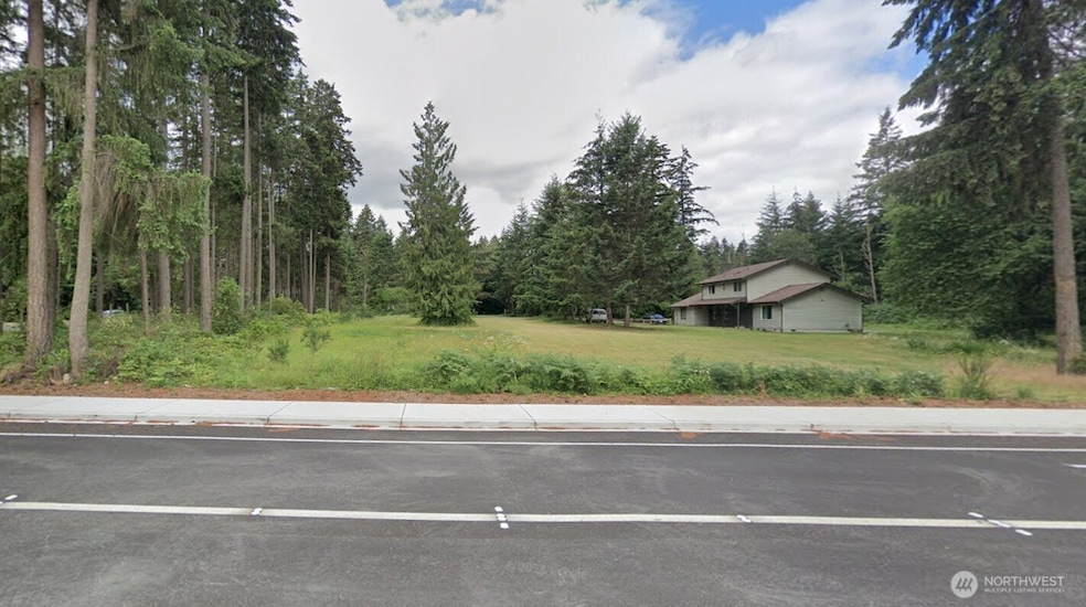
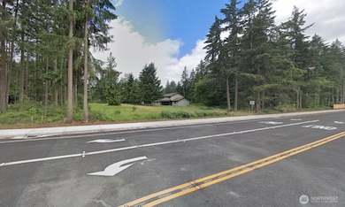
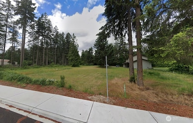
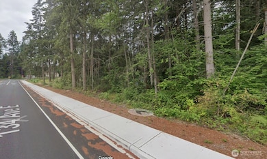
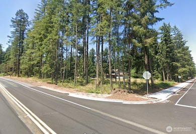
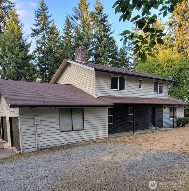
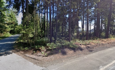
Exceptional Development Opportunity. 2.53 acres featuring an approved 9-lot Short Plat. Situated adjacent to “Daybreak”, newly constructed 134th St, fully re-paved 200th St, sewer+water available close, no wetlands. 1,984 sqft home-4 beds-3 ba-2-car garage-fresh paint inside/out-new deck-new patio-new garage door-newer hot water heater-updated lights. This residence will remain on Lot 6 and is currently rented for $2,600/month. Excellent location and a prime opportunity to build 8 houses. The Comp Plan update to Suburban Residential zoning opens opportunity to develop additional home sites if desired. Seize this chance, and your next project could be ready for construction in the first quarter of 2026!
Collateral Analytics
Collateral Analytics AVMs (Automated Valuation Model) employ a number of statistical approaches combined with neighborhood-specific comparable selection guarantees the most up-to-date and precise valuations.
Not Available
Collateral Analytics does not have data for the current month. Please view the chart for historical values.
ICE
ICE Mortgage Technology
ICE Mortgage Technology’s AVM (Automated Valuation Model) is a state-of-the-art online residential property valuation tool that provides a quick and accurate estimate of the value of almost any home in the U.S.
Not Available
ICE Mortgage Technology does not have data for the current month. Please view the chart for historical values.
First American
First American
First American Data & Analytics’ next-generation AVM combines unrivaled data assets with a blended ensemble of valuation models to produce highly accurate, reliable valuations you can trust.
Not Available
First American does not have data for the current month. Please view the chart for historical values.
Quantarium
Quantarium
Quantarium’s valuation service, repeatedly proven the industry’s most accurate and comprehensive, is supercharged with a self-learning and auto-tuning AI engine that continually becomes smarter and more accurate as it processes daily inputs from the industry’s leading RE data lake.
Not Available
Quantarium does not have data for the current month. Please view the chart for historical values.
Average Value
Not Available
List Price
Sold Price
Create a Home Valuation Report for This Property
The Home Valuation Report is an in-depth analysis detailing your home's value as well as a comparison with similar homes in the area
Home Values in the Area
Source: Public Records
Average Home Value in this Area
Source: Public Records
Tax History
Year
Tax Paid
Tax AssessmentTax Assessment
Total Assessment is a certain percentage of the fair market value that is determined by local assessors to be the total taxable value of land and additions on the property.
Land
Improvement
2025
$4,999
$621,500
$317,500
$304,000
2024
$4,999
$576,800
$310,600
$266,200
2023
$4,999
$546,800
$296,800
$250,000
2022
$4,690
$567,800
$286,500
$281,300
2021
$4,960
$408,300
$188,900
$219,400
2019
$4,649
$376,800
$163,700
$213,100
2018
$4,807
$350,100
$136,000
$214,100
2017
$4,523
$304,300
$108,300
$196,000
2016
$4,165
$248,400
$85,200
$163,200
2014
$3,755
$236,300
$87,500
$148,800
2013
$3,755
$208,000
$78,100
$129,900
Source: Public Records
Property History
Date
Event
Price
List to Sale
Price per Sq Ft
09/05/202509/05/25
For Sale
$1,400,000
--
$706 / Sq Ft
Source: Northwest Multiple Listing Service (NWMLS)
Every real estate transaction should offer outstanding service, respect, and integrity, and I aim to go above and beyond for each client I serve. Grasping my clients' objectives—whether they are purchasing or selling a home, or investing in a development or long-term redevelopment—is crucial. Real estate investments often represent the largest financial decision in a person's life, so ensuring my clients' complete satisfaction is a top priority for me.
Look at this cutie! PRIVACY & SPACE are here for you, friends. 5 acres of land, set at the end of the road, you can have your mini-farm, or pasture for a horse, whatever you want it to be. 784 sqft house has 2 bed and 1 bath, remodeled inside giving all new appliances, new flooring throughout, new roof and decks on front and back. Existing 3 bedroom septic system gives opportunity for adding
Imagine moving into this fully refreshed home, ready to gather friends for the holidays, in a small town with a Big View and a Big Heart. Orting is a lifestyle--full of community, Friday Night Lights, loud basketball games, beautiful parks, the BEST mountain view! This beautiful home has 4 huge bedrooms, plus bonus room, main floor with two living room spaces and two dining spaces, super large
What do we have here? TWO living units or work from home in a completely separate area. Rambler home has 3 beds, 2 baths, large open family room and sweet kitchen. The garage has been converted to a studio suite that includes a kitchenette with sink and mini-fridge, large 3/4 bathroom, and second laundry. Currently used as a cosmetology business. The front of the house has a split entrance,
TWO PARCELS - - 1.38 acres total - - zoned Community Employment in the Parkland-Spanaway-Midland Community Plan, Pierce County jurisdiction. Entitlements in process for a 22,704 sqft warehouse. Wetland approval received, SEPA submitted, sewer plan approved, water availability letter received. Continue with approval for this large warehouse or re-adjust and maximize the two parcels individually.
Barnhill Estates is an exclusive lake-front community that gives you a unique blend of luxury and natural beauty! Expansive 1/4 acres homesites are perfect for building what YOU want! Amenities such as gated entry, private park, shared docks, low bank waterfront ensure a lifestyle of joy and beautiful memories. Low-bank waterfront lots, several lakeside, and spacious interior lots give you
Barnhill Estates is an exclusive lake-front community that gives you a unique blend of luxury and natural beauty! Expansive 1/4 acres homesites are perfect for building what YOU want! Amenities such as gated entry, private park, shared docks, low bank waterfront ensure a lifestyle of joy and beautiful memories. Low-bank waterfront lots, several lakeside, and spacious interior lots give you
Are you looking for a picturesque setting, private gated community, with exclusive waterfront access? This is it and more! Barnhill Estates delivers a unique blend of luxury and natural beauty, 1/4 acre lots perfect for building a dream! Amenities include gated entry, private park, shared docks, low bank waterfront ensuring a lifestyle full of amazing memories and relaxation. Low-bank waterfront
Kristina LinkemTerry Wise & Associates
Source: Northwest Multiple Listing Service (NWMLS)
Disclaimer: Certain information contained herein is derived from information provided by parties other than Homes.com. All information provided is deemed reliable, but is not guaranteed to be accurate and should be independently verified.