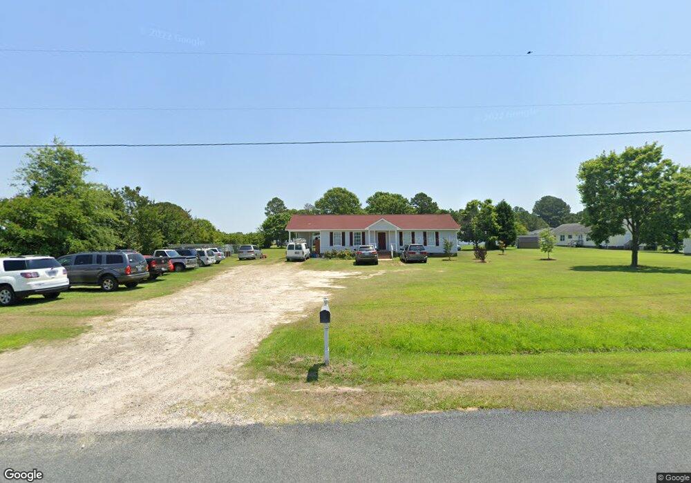
1332 Montague Rd Angier, NC 27501
Estimated Value: $266,000 - $371,000
3
Beds
2
Baths
1,407
Sq Ft
$228/Sq Ft
Est. Value
About This Home
This home is located at 1332 Montague Rd, Angier, NC 27501 and is currently estimated at $320,573, approximately $227 per square foot. 1332 Montague Rd is a home located in Harnett County with nearby schools including Angier Elementary School, North Harnett Primary School, and Harnett Central Middle School.
Ownership History
Date
Name
Owned For
Owner Type
Purchase Details
Closed on
Jan 18, 2022
Sold by
Fuentes Gonzalez Juan Alberto and Ros Alma
Bought by
Vazquez Nayely Fuentes
Current Estimated Value
Purchase Details
Closed on
May 17, 2007
Sold by
Mcclelland Timothy D and Mary A Golden Trust
Bought by
Gonzalez Juan Alberto and Fuentes Alama Rosa Vazquez
Home Financials for this Owner
Home Financials are based on the most recent Mortgage that was taken out on this home.
Original Mortgage
$117,500
Interest Rate
10.95%
Mortgage Type
Adjustable Rate Mortgage/ARM
Create a Home Valuation Report for This Property
The Home Valuation Report is an in-depth analysis detailing your home's value as well as a comparison with similar homes in the area
Home Values in the Area
Average Home Value in this Area
Purchase History
| Date | Buyer | Sale Price | Title Company |
|---|---|---|---|
| Vazquez Nayely Fuentes | $13,000 | None Listed On Document | |
| Gonzalez Juan Alberto | $118,000 | None Available |
Source: Public Records
Mortgage History
| Date | Status | Borrower | Loan Amount |
|---|---|---|---|
| Previous Owner | Gonzalez Juan Alberto | $117,500 |
Source: Public Records
Tax History Compared to Growth
Tax History
| Year | Tax Paid | Tax Assessment Tax Assessment Total Assessment is a certain percentage of the fair market value that is determined by local assessors to be the total taxable value of land and additions on the property. | Land | Improvement |
|---|---|---|---|---|
| 2025 | $1,702 | $239,156 | $0 | $0 |
| 2024 | $1,618 | $226,713 | $0 | $0 |
| 2023 | $1,595 | $226,713 | $0 | $0 |
| 2022 | $990 | $226,713 | $0 | $0 |
| 2021 | $990 | $110,310 | $0 | $0 |
| 2020 | $990 | $110,310 | $0 | $0 |
| 2019 | $975 | $110,310 | $0 | $0 |
| 2018 | $975 | $110,310 | $0 | $0 |
| 2017 | $975 | $110,310 | $0 | $0 |
| 2016 | $1,022 | $116,130 | $0 | $0 |
| 2015 | $1,022 | $116,130 | $0 | $0 |
| 2014 | $1,022 | $116,130 | $0 | $0 |
Source: Public Records
Map
Nearby Homes
- Appalachian Plan at Riverfall
- Redwood Plan at Riverfall
- Voyageur Plan at Riverfall
- Clearwater Plan at Riverfall
- Allegheny Plan at Riverfall
- 77 Mendenhall Dr
- Shenandoah Plan at Riverfall
- Sequoia Plan at Riverfall
- Teton Plan at Riverfall
- 202 Denali Dr Unit Lot 27
- 167 Bering Cir Unit Lot 10
- 467 Denali Dr
- 591 White Birch Ln
- 21 Silver Pine Dr
- 25 Silver Pine Dr
- 17 Silver Pine Dr
- 13 Silver Pine Dr
- 11 Silver Pine Dr
- 630 White Birch Ln
- 38 Hoff Ct