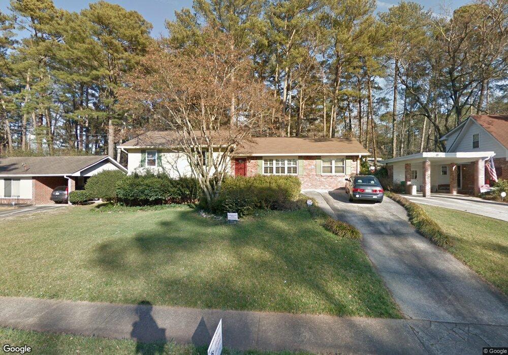
1333 Faraday Place Unit 2 Decatur, GA 30033
North Druid Woods NeighborhoodEstimated Value: $521,000 - $597,000
3
Beds
3
Baths
2,342
Sq Ft
$237/Sq Ft
Est. Value
About This Home
This home is located at 1333 Faraday Place Unit 2, Decatur, GA 30033 and is currently estimated at $554,651, approximately $236 per square foot. 1333 Faraday Place Unit 2 is a home located in DeKalb County with nearby schools including Laurel Ridge Elementary School, Druid Hills Middle School, and Druid Hills High School.
Ownership History
Date
Name
Owned For
Owner Type
Purchase Details
Closed on
Aug 9, 2001
Sold by
Turner Michael R
Bought by
Cobham-Owens Karen E
Current Estimated Value
Home Financials for this Owner
Home Financials are based on the most recent Mortgage that was taken out on this home.
Original Mortgage
$158,450
Outstanding Balance
$61,284
Interest Rate
7.19%
Mortgage Type
New Conventional
Estimated Equity
$493,367
Purchase Details
Closed on
Mar 28, 1997
Sold by
Jones Mark Frances
Bought by
Turner Michael
Create a Home Valuation Report for This Property
The Home Valuation Report is an in-depth analysis detailing your home's value as well as a comparison with similar homes in the area
Home Values in the Area
Average Home Value in this Area
Purchase History
| Date | Buyer | Sale Price | Title Company |
|---|---|---|---|
| Cobham-Owens Karen E | $198,100 | -- | |
| Turner Michael | $144,900 | -- |
Source: Public Records
Mortgage History
| Date | Status | Borrower | Loan Amount |
|---|---|---|---|
| Open | Cobham-Owens Karen E | $158,450 | |
| Closed | Turner Michael | $0 |
Source: Public Records
Tax History Compared to Growth
Tax History
| Year | Tax Paid | Tax Assessment Tax Assessment Total Assessment is a certain percentage of the fair market value that is determined by local assessors to be the total taxable value of land and additions on the property. | Land | Improvement |
|---|---|---|---|---|
| 2025 | $6,516 | $225,800 | $41,120 | $184,680 |
| 2024 | $6,503 | $215,480 | $41,120 | $174,360 |
| 2023 | $6,503 | $188,400 | $41,120 | $147,280 |
| 2022 | $5,668 | $179,240 | $41,120 | $138,120 |
| 2021 | $5,491 | $171,600 | $40,000 | $131,600 |
| 2020 | $5,551 | $173,920 | $40,000 | $133,920 |
| 2019 | $4,617 | $161,280 | $40,000 | $121,280 |
| 2018 | $3,943 | $139,640 | $40,000 | $99,640 |
| 2017 | $3,572 | $107,840 | $16,000 | $91,840 |
| 2016 | $3,283 | $98,880 | $13,440 | $85,440 |
| 2014 | $3,119 | $93,040 | $13,440 | $79,600 |
Source: Public Records
Map
Nearby Homes
- 2396 Lawrenceville Hwy Unit F
- 2396 Lawrenceville Hwy Unit V
- 2396 Lawrenceville Hwy
- 2386 Lawrenceville Hwy Unit G
- 2388 Lawrenceville Hwy Unit D
- 3023 Mount Olive Dr
- 2951 Haralson Rd
- 1263 Blueberry Trail
- 2427 Lawrenceville Hwy Unit 4
- 1300 Hopkins Dr
- 3080 Turman Cir
- 3084 Turman Cir
- 3107 Turman Cir
- 3038 Flamingo Dr
- 2937 Mount Olive Dr
- 1463 Crescent Walk
- 2700 Hawaii Ct
- 1339 Faraday Place
- 1327 Faraday Place Unit 2
- 0 Faraday Place Unit 7129797
- 0 Faraday Place
- 1332 Talcott Place Unit 2
- 1345 Faraday Place
- 1321 Faraday Place
- 1326 Talcott Place
- 1344 Talcott Place Unit 2
- 1336 Faraday Place
- 1320 Talcott Place
- 1351 Faraday Place
- 1315 Faraday Place Unit 2
- 1330 Faraday Place
- 1342 Faraday Place
- 0 Talcott Place Unit 8287914
- 0 Talcott Place Unit 3234878
- 0 Talcott Place Unit 7177862
- 0 Talcott Place Unit 8842841
- 0 Talcott Place Unit 3266876