Estimated Value: $137,000 - $180,000
3
Beds
2
Baths
1,560
Sq Ft
$107/Sq Ft
Est. Value
About This Home
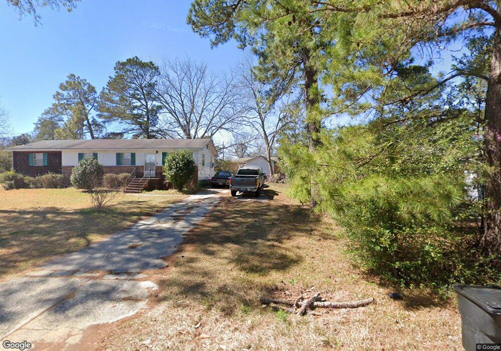
This home is located at 1333 Grant St, Perry, GA 31069 and is currently estimated at $166,693, approximately $106 per square foot. 1333 Grant St is a home located in Houston County with nearby schools including Morningside Elementary School, Perry Middle School, and Perry High School.
Ownership History
Date
Name
Owned For
Owner Type
Purchase Details
Closed on
Oct 1, 1971
Sold by
Thomas & Hill Inc
Bought by
Tharpe Richard and Tharpe Mary L
Current Estimated Value
Purchase Details
Closed on
Dec 1, 1970
Sold by
Tharpe Richard and Tharpe Mary L
Bought by
Thomas & Hill Inc
Purchase Details
Closed on
Jul 15, 1970
Sold by
Davis Company Inc
Bought by
Tharpe Richard and Tharpe Mary L
Create a Home Valuation Report for This Property
The Home Valuation Report is an in-depth analysis detailing your home's value as well as a comparison with similar homes in the area
Home Values in the Area
Average Home Value in this Area
Purchase History
| Date | Buyer | Sale Price | Title Company |
|---|---|---|---|
| Tharpe Richard | -- | -- | |
| Thomas & Hill Inc | -- | -- | |
| Tharpe Richard | -- | -- |
Source: Public Records
Tax History
| Year | Tax Paid | Tax Assessment Tax Assessment Total Assessment is a certain percentage of the fair market value that is determined by local assessors to be the total taxable value of land and additions on the property. | Land | Improvement |
|---|---|---|---|---|
| 2024 | $961 | $34,880 | $3,360 | $31,520 |
| 2023 | $743 | $28,800 | $3,360 | $25,440 |
| 2022 | $401 | $26,600 | $3,360 | $23,240 |
| 2021 | $344 | $24,000 | $3,360 | $20,640 |
| 2020 | $346 | $23,880 | $3,360 | $20,520 |
| 2019 | $342 | $23,880 | $3,360 | $20,520 |
| 2018 | $342 | $23,880 | $3,360 | $20,520 |
| 2017 | $343 | $23,880 | $3,360 | $20,520 |
| 2016 | $343 | $23,880 | $3,360 | $20,520 |
| 2015 | $343 | $23,880 | $3,360 | $20,520 |
| 2014 | -- | $23,880 | $3,360 | $20,520 |
| 2013 | -- | $23,880 | $3,360 | $20,520 |
Source: Public Records
Map
Nearby Homes
- 100 Flat Rock Ln
- 215 Cattle Dr
- 1402 Park Ave
- 1418 Parkway Dr
- 1729 Milton Way
- 1739 Houston Lake Rd
- 1304 Davis Ave
- 102 Ridge Cir N
- 1212 Swift St
- 0 Carroll Aly
- 1312 Keith Dr
- 500 Legacy Park Dr
- 102 N Haven Ln
- The Pearson Plan at Avalon
- The Crawford Plan at Avalon
- The Piedmont Plan at Avalon
- The McGinnis Plan at Avalon
- The Coleman Plan at Avalon
- The Lawson Plan at Avalon
- The Bradley Plan at Avalon
- 1335 Grant St
- 1330 Pierce St
- 1332 Pierce St
- 1327 Grant St
- 2018 Sam Nunn Blvd N
- 1340 Grant St
- 1326 Pierce St
- 501 New Hope Dr
- 414 New Hope Dr
- 416 New Hope Dr
- 415 New Hope Dr
- 413 New Hope Dr
- 411 New Hope Dr
- 409 New Hope Dr
- 412 New Hope Dr
- 410 New Hope Dr
- 405 New Hope Dr
- 406 New Hope Dr
- 404 New Hope Dr
- 402 New Hope Dr
Your Personal Tour Guide
Ask me questions while you tour the home.