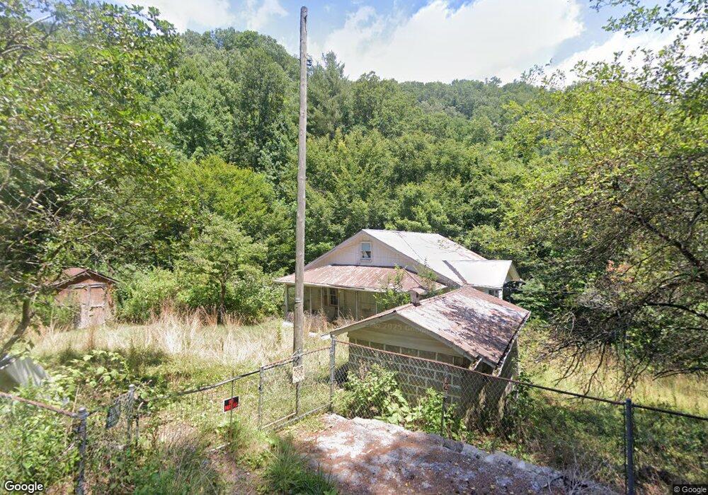
1333 Robinson Fork Rd Vansant, VA 24656
Estimated Value: $52,440 - $77,000
2
Beds
1
Bath
1,302
Sq Ft
$53/Sq Ft
Est. Value
About This Home
This home is located at 1333 Robinson Fork Rd, Vansant, VA 24656 and is currently estimated at $68,610, approximately $52 per square foot. 1333 Robinson Fork Rd is a home located in Buchanan County with nearby schools including Council Elementary-Middle School and Council High School.
Ownership History
Date
Name
Owned For
Owner Type
Purchase Details
Closed on
Jan 28, 2014
Sold by
Troup Jonathan and Blystone Leanne
Bought by
Lapointe Michelle L
Current Estimated Value
Purchase Details
Closed on
Jun 5, 2009
Sold by
Street Ronnie R
Bought by
Troup Jonathan and Blystone Leanne
Home Financials for this Owner
Home Financials are based on the most recent Mortgage that was taken out on this home.
Original Mortgage
$23,400
Interest Rate
4.83%
Mortgage Type
Purchase Money Mortgage
Create a Home Valuation Report for This Property
The Home Valuation Report is an in-depth analysis detailing your home's value as well as a comparison with similar homes in the area
Purchase History
| Date | Buyer | Sale Price | Title Company |
|---|---|---|---|
| Lapointe Michelle L | $23,000 | Attorney | |
| Troup Jonathan | $26,000 | None Available |
Source: Public Records
Mortgage History
| Date | Status | Borrower | Loan Amount |
|---|---|---|---|
| Previous Owner | Troup Jonathan | $23,400 |
Source: Public Records
Tax History
| Year | Tax Paid | Tax Assessment Tax Assessment Total Assessment is a certain percentage of the fair market value that is determined by local assessors to be the total taxable value of land and additions on the property. | Land | Improvement |
|---|---|---|---|---|
| 2025 | $88 | $22,600 | $7,400 | $15,200 |
| 2024 | $88 | $22,600 | $7,400 | $15,200 |
| 2023 | $88 | $22,600 | $7,400 | $15,200 |
| 2022 | $88 | $22,600 | $7,400 | $15,200 |
| 2021 | $88 | $22,600 | $7,400 | $15,200 |
| 2020 | $99 | $25,400 | $7,400 | $18,000 |
| 2019 | $99 | $25,400 | $7,400 | $18,000 |
| 2017 | $99 | $25,400 | $7,400 | $18,000 |
| 2016 | $99 | $25,400 | $7,400 | $18,000 |
| 2015 | -- | $0 | $0 | $0 |
Source: Public Records
Map
Nearby Homes
- 7016 Hurricane Creek Rd
- 8232 Garden Creek Rd
- 1460 Gum Branch Rd
- 9725 Garden Creek Rd
- 2477 Leemaster Dr
- 1087 Greenhouse Cir
- 1040 Red Jacket Rd
- 1877 Lovers Gap Rd
- 1342 Quinn Branch Rd
- 10388 Helen Henderson Hwy
- 1332 G P Branch Rd
- 18775 Riverside Dr
- Tbd Lynn Springs Rd
- 3687 Old Kentucky Turnpike Rd
- 3630 Combs Ridge Rd
- 370 Jackie Dye Rd
- 1551 Watkins Branch
- 1059 Shady Lane St
- 483 Long Branch
- 1107 Russell Hill St
- 1326 Robinson Fork Rd
- 1435 Robinson Fork Rd
- 1358 Robinson Fork Rd
- 1874 Indian Grave Gap Rd
- 1145 Owls Nest Rd
- 1862 Indian Grave Gap Rd
- 1873 Indian Grave Gap Rd
- 1087 Owls Nest Rd
- 2340 Indian Grave Gap Rd
- 2009 Indian Grave Gap Rd
- 2337 Indian Grave Gap Rd
- 1004 Ambrosia Rd
- 1206 Turkey Gap Rd
- 1206 Turkey Gap Rd
- 1412 Ambrosia Rd
- 1101 Turkey Gap Rd
- 1192 Ambrosia Rd
- 1256 Ambrosia Rd
- 1180 D j Dr
- 1740 Indian Grave Gap Rd
Your Personal Tour Guide
Ask me questions while you tour the home.