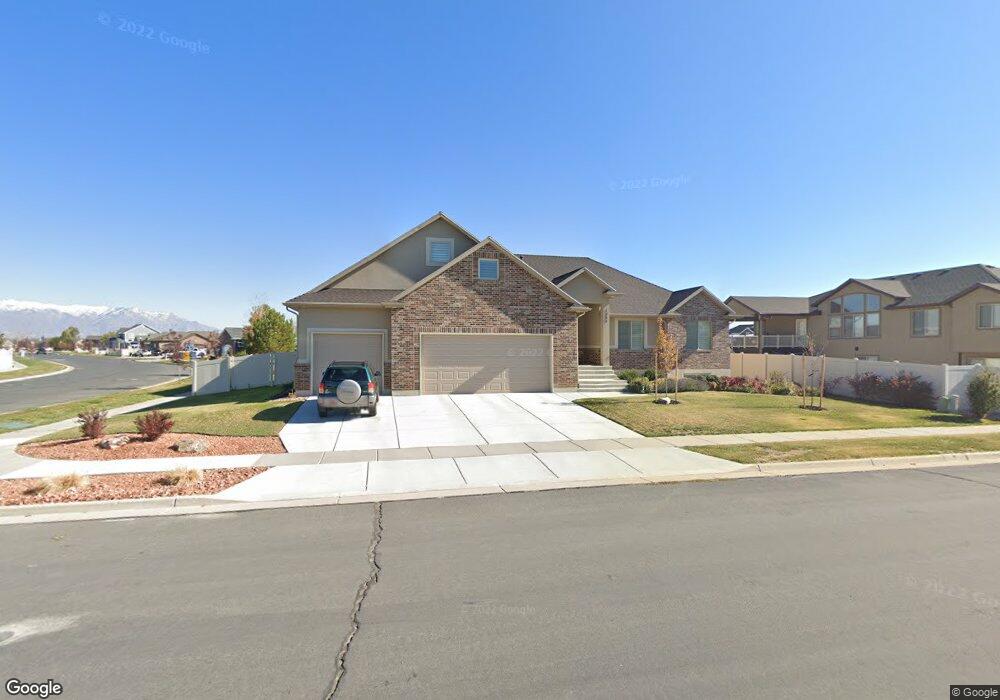
1333 S 4465 W Syracuse, UT 84075
Estimated Value: $690,000 - $770,387
4
Beds
3
Baths
2,136
Sq Ft
$337/Sq Ft
Est. Value
About This Home
This home is located at 1333 S 4465 W, Syracuse, UT 84075 and is currently estimated at $720,847, approximately $337 per square foot. 1333 S 4465 W is a home with nearby schools including Buffalo Point School, Syracuse Junior High School, and Syracuse High School.
Ownership History
Date
Name
Owned For
Owner Type
Purchase Details
Closed on
Dec 30, 2016
Sold by
Elite Craft Homes Llc
Bought by
Johnson Robert D and Johnson Etsuko
Current Estimated Value
Home Financials for this Owner
Home Financials are based on the most recent Mortgage that was taken out on this home.
Original Mortgage
$120,000
Outstanding Balance
$98,133
Interest Rate
3.94%
Mortgage Type
New Conventional
Estimated Equity
$622,714
Purchase Details
Closed on
Jul 9, 2009
Sold by
Preston Jerry
Bought by
Preston Tamera H and Preston Jerry J
Purchase Details
Closed on
Jun 26, 2009
Sold by
Bridgeway Island Llc
Bought by
Preston Jerry
Create a Home Valuation Report for This Property
The Home Valuation Report is an in-depth analysis detailing your home's value as well as a comparison with similar homes in the area
Home Values in the Area
Average Home Value in this Area
Purchase History
| Date | Buyer | Sale Price | Title Company |
|---|---|---|---|
| Johnson Robert D | -- | Stewart Title | |
| Preston Tamera H | -- | Accommodation | |
| Preston Jerry | -- | Accommodation |
Source: Public Records
Mortgage History
| Date | Status | Borrower | Loan Amount |
|---|---|---|---|
| Open | Johnson Robert D | $120,000 |
Source: Public Records
Tax History Compared to Growth
Tax History
| Year | Tax Paid | Tax Assessment Tax Assessment Total Assessment is a certain percentage of the fair market value that is determined by local assessors to be the total taxable value of land and additions on the property. | Land | Improvement |
|---|---|---|---|---|
| 2025 | $4,082 | $393,800 | $106,483 | $287,317 |
| 2024 | $3,873 | $376,200 | $87,308 | $288,892 |
| 2023 | $3,644 | $645,000 | $130,115 | $514,885 |
| 2022 | $3,815 | $370,150 | $66,458 | $303,692 |
| 2021 | $3,362 | $505,000 | $96,730 | $408,270 |
| 2020 | $3,205 | $466,000 | $79,397 | $386,603 |
| 2019 | $3,086 | $443,000 | $82,311 | $360,689 |
| 2018 | $2,905 | $414,000 | $79,627 | $334,373 |
| 2016 | $795 | $59,378 | $59,378 | $0 |
| 2015 | $836 | $59,463 | $59,463 | $0 |
| 2014 | $820 | $59,463 | $59,463 | $0 |
| 2013 | -- | $55,888 | $55,888 | $0 |
Source: Public Records
Map
Nearby Homes
- 1155 S 4475 W
- 1157 S 4425 W
- 1139 S 4475 W
- 1125 S 4475 W
- 4578 W 1150 S
- 4191 W 1425 S
- 1068 S 4425 W
- 1141 S 4700 W
- Bradford Plan at Harvest Fields
- Avery Plan at Harvest Fields
- Sullivan Plan at Harvest Fields
- Presley Plan at Harvest Fields
- Ashmore Plan at Harvest Fields
- Bridgeport Plan at Harvest Fields
- Malan Plan at Harvest Fields
- Havenwood Plan at Harvest Fields
- Hamilton Plan at Harvest Fields
- Havenwood with Loft Plan at Harvest Fields
- 4468 W 1050 S
- 4580 W 1700 S
- 4429 W 1315 S Unit 223
- 4444 W 1350 S Unit 233
- 4420 W 1350 S Unit 234
- 4420 W 1350 S Unit 30
- 4391 W 1315 S
- 1301 S 4465 W
- 4484 W 1315 S
- 4483 W 1315 S
- 4392 W 1350 S
- 4392 W 1350 S Unit 235
- 4364 W 1350 S
- 1346 S 4465 W Unit 208
- 1346 S 4465 W
- 4361 W 1315 S
- 1298 S 4465 W Unit 210
- 4421 W 1350 S
- 1302 S 4350 W Unit 220
- 1281 S 4465 W
- 4447 W 1350 S Unit 239
- 1366 S 4465 W Unit 207