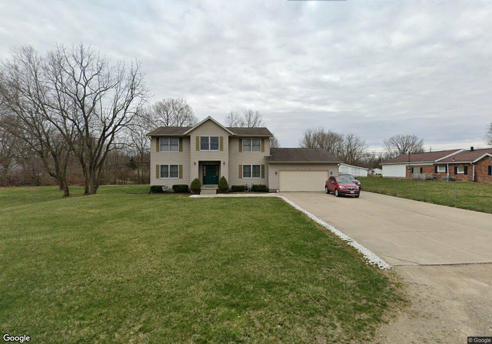
1333 W Johnny Lytle Ave Springfield, OH 45506
Estimated Value: $161,000 - $234,000
4
Beds
3
Baths
2,474
Sq Ft
$83/Sq Ft
Est. Value
About This Home
This home is located at 1333 W Johnny Lytle Ave, Springfield, OH 45506 and is currently estimated at $204,903, approximately $82 per square foot. 1333 W Johnny Lytle Ave is a home located in Clark County with nearby schools including Fulton Elementary School, Hayward Middle School, and Springfield High School.
Ownership History
Date
Name
Owned For
Owner Type
Purchase Details
Closed on
May 19, 2016
Sold by
Rentals Llc
Bought by
Roe Dwight C and Roe Cheryl L
Current Estimated Value
Purchase Details
Closed on
May 13, 2016
Sold by
Roe Dwight C and Roe Cheryl L
Bought by
Roe Roe Rentals Llc
Purchase Details
Closed on
Nov 6, 1996
Sold by
Portis Larry A
Bought by
Roe Dwight C and Roe Cheryl
Purchase Details
Closed on
Sep 1, 1980
Create a Home Valuation Report for This Property
The Home Valuation Report is an in-depth analysis detailing your home's value as well as a comparison with similar homes in the area
Home Values in the Area
Average Home Value in this Area
Purchase History
| Date | Buyer | Sale Price | Title Company |
|---|---|---|---|
| Roe Dwight C | -- | None Available | |
| Roe Roe Rentals Llc | -- | None Available | |
| Roe Dwight C | $5,000 | -- | |
| -- | $1,000 | -- |
Source: Public Records
Tax History
| Year | Tax Paid | Tax Assessment Tax Assessment Total Assessment is a certain percentage of the fair market value that is determined by local assessors to be the total taxable value of land and additions on the property. | Land | Improvement |
|---|---|---|---|---|
| 2025 | $2,514 | $69,190 | $2,670 | $66,520 |
| 2024 | -- | $49,600 | $2,140 | $47,460 |
| 2023 | $2,450 | $49,600 | $2,140 | $47,460 |
| 2022 | $104 | $49,600 | $2,140 | $47,460 |
| 2021 | $2,433 | $44,280 | $1,910 | $42,370 |
| 2020 | $2,439 | $44,280 | $1,910 | $42,370 |
| 2019 | $2,445 | $44,280 | $1,910 | $42,370 |
| 2018 | $2,313 | $40,220 | $1,910 | $38,310 |
| 2017 | $2,312 | $40,223 | $1,908 | $38,315 |
| 2016 | $2,251 | $40,223 | $1,908 | $38,315 |
| 2015 | $1,251 | $40,223 | $1,908 | $38,315 |
| 2014 | $867 | $40,223 | $1,908 | $38,315 |
| 2013 | $1,130 | $40,223 | $1,908 | $38,315 |
Source: Public Records
Map
Nearby Homes
- 1109 Montgomery Ave
- 0 Montgomery Ave
- 929 S Western Ave
- 802 Innisfallen Ave
- 1920 Russell Ave
- 830 Dibert Ave
- 1207 W Pleasant St
- 1002 S Yellow Springs St
- 1230 W Pleasant St
- 2000 Springmont Ave
- 1618 W Pleasant St
- 550 W Parkwood Ave
- 2140 Shawnee Ave
- 506 W Southern Ave
- 525 S Light St
- 405 W Southern Ave
- 518 Hazelbrook Ave
- 202 Seever St
- 410 W Liberty St
- 1225 W High St
- 1339 W Johnny Lytle Ave
- 1332 W Perrin Ave
- 1352 W Perrin Ave
- 1326 W Perrin Ave
- 1401 W Johnny Lytle Ave
- 1320 W Perrin Ave
- 1323 W State St
- 1308 W Perrin Ave
- 1406 W Perrin Ave
- 1345 W Perrin Ave
- 1345 W Perrin Ave
- 1408 W Perrin Ave
- 1314 W Perrin Ave
- 1325 W Perrin Ave
- 1261 Wisconsin Ave
- 1203 Wisconsin Ave
- 1271 Wisconsin Ave
- 1407 W Perrin Ave
- 1410 W Perrin Ave
- 1291 Wisconsin Ave
Your Personal Tour Guide
Ask me questions while you tour the home.