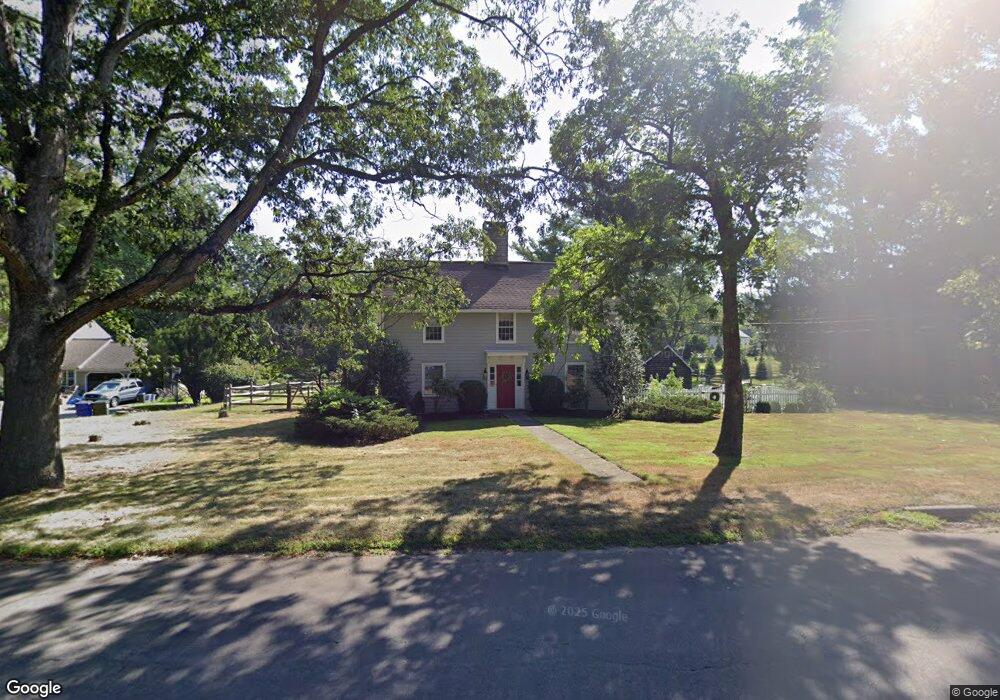
1334 Bronson Rd Fairfield, CT 06824
University NeighborhoodEstimated Value: $1,036,000 - $1,581,000
3
Beds
3
Baths
2,626
Sq Ft
$494/Sq Ft
Est. Value
About This Home
This home is located at 1334 Bronson Rd, Fairfield, CT 06824 and is currently estimated at $1,297,865, approximately $494 per square foot. 1334 Bronson Rd is a home located in Fairfield County with nearby schools including Mill Hill School, Roger Ludlowe Middle School, and Fairfield Ludlowe High School.
Ownership History
Date
Name
Owned For
Owner Type
Purchase Details
Closed on
Dec 10, 1986
Bought by
Young Lawrence B and Young Rosanne
Current Estimated Value
Create a Home Valuation Report for This Property
The Home Valuation Report is an in-depth analysis detailing your home's value as well as a comparison with similar homes in the area
Home Values in the Area
Average Home Value in this Area
Purchase History
| Date | Buyer | Sale Price | Title Company |
|---|---|---|---|
| Young Lawrence B | $386,000 | -- |
Source: Public Records
Mortgage History
| Date | Status | Borrower | Loan Amount |
|---|---|---|---|
| Open | Young Lawrence B | $667,200 | |
| Closed | Young Lawrence B | $620,000 | |
| Closed | Young Lawrence B | $439,000 |
Source: Public Records
Tax History Compared to Growth
Tax History
| Year | Tax Paid | Tax Assessment Tax Assessment Total Assessment is a certain percentage of the fair market value that is determined by local assessors to be the total taxable value of land and additions on the property. | Land | Improvement |
|---|---|---|---|---|
| 2025 | $15,964 | $562,310 | $372,470 | $189,840 |
| 2024 | $15,688 | $562,310 | $372,470 | $189,840 |
| 2023 | $15,469 | $562,310 | $372,470 | $189,840 |
| 2022 | $15,317 | $562,310 | $372,470 | $189,840 |
| 2021 | $15,171 | $562,310 | $372,470 | $189,840 |
| 2020 | $16,019 | $597,940 | $368,270 | $229,670 |
| 2019 | $16,019 | $597,940 | $368,270 | $229,670 |
| 2018 | $15,762 | $597,940 | $368,270 | $229,670 |
| 2017 | $15,439 | $597,940 | $368,270 | $229,670 |
| 2016 | $15,218 | $597,940 | $368,270 | $229,670 |
| 2015 | $15,293 | $616,910 | $393,260 | $223,650 |
| 2014 | $15,053 | $616,910 | $393,260 | $223,650 |
Source: Public Records
Map
Nearby Homes
- 647 Bronson Rd
- 105 Charter Oak Rd
- 360 Duck Farm Rd
- 844 Mill Hill Terrace
- 218 Lower Farm Rd
- 20 Ermine St
- 2683 Bronson Rd
- 245 Unquowa Rd Unit 6
- 21 Beaumont St
- 153 Pease Ave
- 688 Hulls Farm Rd
- 88 Overhill Rd
- 168 Wormwood Rd
- 65 Thorpe St Unit 65
- 43 Helen St
- 1207 Stillson Rd
- 209 S Pine Creek Rd
- 15 Barton Rd
- 327 Meadowbrook Rd
- 2 Elmwood Dr Unit 2
- 1341 Bronson Rd
- 1372 Bronson Rd
- 35 Cider Mill Ln
- 1371 Bronson Rd
- 1400 Bronson Rd
- 20 Cider Mill Ln
- 1285 Bronson Rd
- 55 Cider Mill Ln
- 55 Cider Mill Ln Unit Cottage
- 40 Cider Mill Ln
- 10 Twin Brooks Ln
- 1327 Bronson Rd
- 1327 Bronson Rd Unit 1
- 1375 Bronson Rd
- 1263 Bronson Rd
- 75 Cider Mill Ln
- 1222 Bronson Rd
- 70 Cider Mill Ln
- 916 Sturges Hwy
- 1218 Bronson Rd