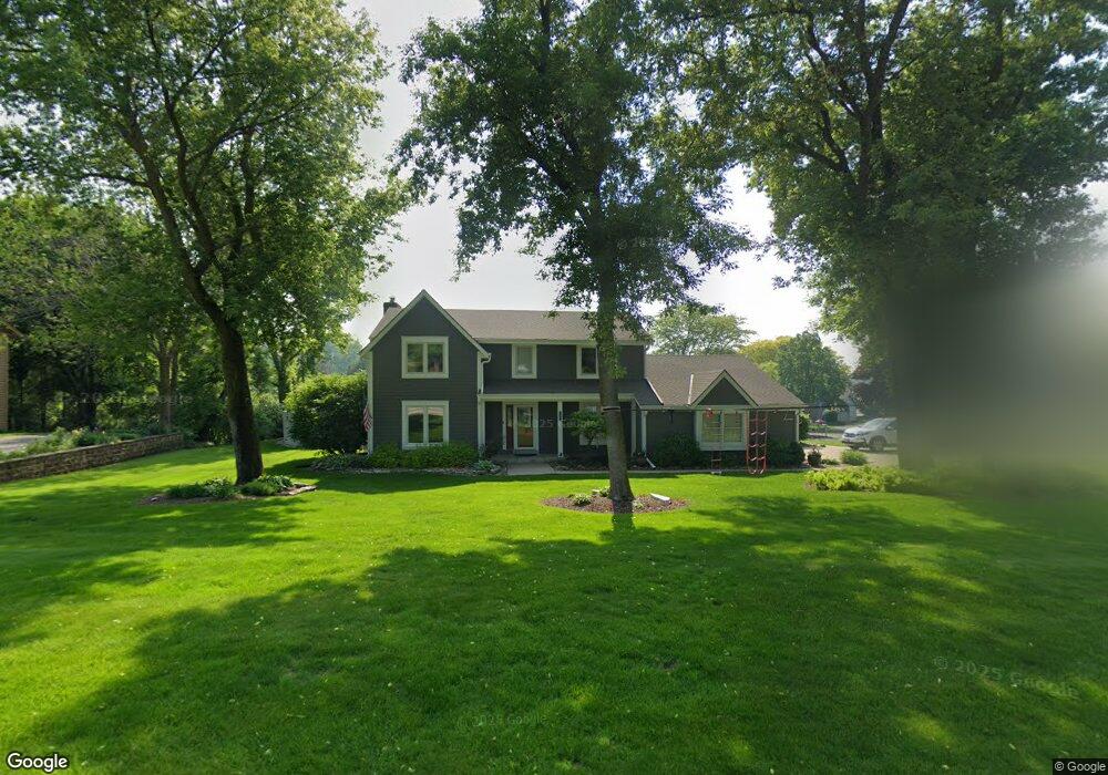
1335 Independence Dr Brookfield, WI 53045
Estimated Value: $582,000 - $646,000
4
Beds
3
Baths
2,495
Sq Ft
$245/Sq Ft
Est. Value
About This Home
This home is located at 1335 Independence Dr, Brookfield, WI 53045 and is currently estimated at $610,262, approximately $244 per square foot. 1335 Independence Dr is a home located in Waukesha County with nearby schools including Brookfield Elementary School, Wisconsin Hills Middle School, and Brookfield Central High School.
Ownership History
Date
Name
Owned For
Owner Type
Purchase Details
Closed on
Nov 3, 2021
Sold by
Corona Anthony Victor
Bought by
Corona Trust
Current Estimated Value
Purchase Details
Closed on
Mar 8, 2004
Sold by
Corona Anthony V
Bought by
The Trust Of Anthony V Corona
Purchase Details
Closed on
May 14, 2003
Sold by
Jenders James E and Jenders Deborah L
Bought by
Corona Anthony
Home Financials for this Owner
Home Financials are based on the most recent Mortgage that was taken out on this home.
Original Mortgage
$214,000
Interest Rate
5.9%
Mortgage Type
Purchase Money Mortgage
Create a Home Valuation Report for This Property
The Home Valuation Report is an in-depth analysis detailing your home's value as well as a comparison with similar homes in the area
Home Values in the Area
Average Home Value in this Area
Purchase History
| Date | Buyer | Sale Price | Title Company |
|---|---|---|---|
| Corona Trust | -- | None Available | |
| The Trust Of Anthony V Corona | -- | -- | |
| Corona Anthony | $316,500 | -- |
Source: Public Records
Mortgage History
| Date | Status | Borrower | Loan Amount |
|---|---|---|---|
| Previous Owner | Corona Anthony | $214,000 | |
| Closed | Corona Anthony | $39,200 |
Source: Public Records
Tax History Compared to Growth
Tax History
| Year | Tax Paid | Tax Assessment Tax Assessment Total Assessment is a certain percentage of the fair market value that is determined by local assessors to be the total taxable value of land and additions on the property. | Land | Improvement |
|---|---|---|---|---|
| 2024 | $5,165 | $463,800 | $135,000 | $328,800 |
| 2023 | $5,165 | $463,800 | $135,000 | $328,800 |
| 2022 | $5,336 | $374,400 | $130,000 | $244,400 |
| 2021 | $5,650 | $374,400 | $130,000 | $244,400 |
| 2020 | $5,897 | $374,400 | $130,000 | $244,400 |
| 2019 | $5,663 | $374,400 | $130,000 | $244,400 |
| 2018 | $5,372 | $345,700 | $130,000 | $215,700 |
| 2017 | $6,185 | $345,700 | $130,000 | $215,700 |
| 2016 | $5,453 | $345,700 | $130,000 | $215,700 |
| 2015 | $5,423 | $345,700 | $130,000 | $215,700 |
| 2014 | $5,626 | $345,700 | $130,000 | $215,700 |
| 2013 | $5,626 | $345,700 | $130,000 | $215,700 |
Source: Public Records
Map
Nearby Homes
- 20025 Freedom Ct
- 1375 Barrington Woods Dr
- 1660 Constitution Dr
- 950 N Barker Rd
- 1345 Overlook Cir
- 1135 Greenridge Terrace
- 19775 Trilby Ct
- 19250 Benington Dr
- 890 Janacek Rd
- 19145 Arlyne Ct
- 1485 N Brookfield Rd
- 18660 Bonnie Ln
- 18880 Toldt Woods Dr Unit 6
- 20780 Tennyson Dr
- 21300 Astolat Dr
- 21905 W North Ave
- 2423 Kossow Rd
- N19W22081 Foxview Ct Unit 2B
- 21710 Astolat Dr
- 2480 Lionel Ct
- 1315 Independence Dr
- 20335 Yorktown Ct
- 1360 Centennial Ct
- 20365 Yorktown Ct
- 20330 Yorktown Ct
- 20360 Yorktown Ct
- 1310 Centennial Ct
- 1395 Independence Dr
- 1350 Centennial Ct
- 20335 Trenton Ct
- 1330 Centennial Ct
- 1400 Independence Dr
- 20180 Independence Dr
- 20185 Independence Dr Unit A
- 20185 Independence Dr Unit B
- 20155 Independence Dr Unit A
- 20185 Independence Dr Unit C
- 20155 Independence Dr Unit C
- 20185 Independence Dr Unit D
- 20155 Independence Dr Unit B