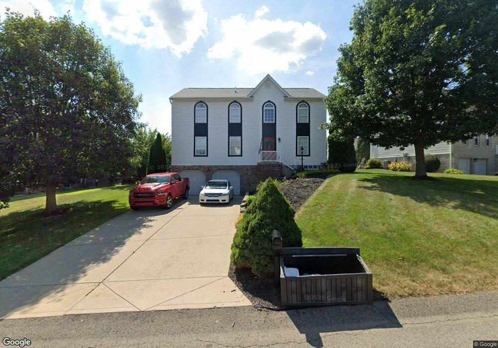
1336 Morgan Cir Canonsburg, PA 15317
Estimated Value: $428,000 - $496,000
4
Beds
4
Baths
2,436
Sq Ft
$193/Sq Ft
Est. Value
About This Home
This home is located at 1336 Morgan Cir, Canonsburg, PA 15317 and is currently estimated at $471,233, approximately $193 per square foot. 1336 Morgan Cir is a home located in Washington County with nearby schools including Canon-Mcmillan Senior High School.
Ownership History
Date
Name
Owned For
Owner Type
Purchase Details
Closed on
Jun 12, 2023
Sold by
Bonifield Family Revocable Living Trust
Bought by
Bonifield Family Real Estate Protector Trust and Bonifield
Current Estimated Value
Purchase Details
Closed on
May 9, 2023
Sold by
Bonifield Bradley R and Bonifield Mary Lynn
Bought by
Bonifield Family Revocable Living Trust
Create a Home Valuation Report for This Property
The Home Valuation Report is an in-depth analysis detailing your home's value as well as a comparison with similar homes in the area
Home Values in the Area
Average Home Value in this Area
Purchase History
| Date | Buyer | Sale Price | Title Company |
|---|---|---|---|
| Bonifield Family Real Estate Protector Trust | -- | None Listed On Document | |
| Bonifield Family Revocable Living Trust | -- | None Listed On Document |
Source: Public Records
Tax History Compared to Growth
Tax History
| Year | Tax Paid | Tax Assessment Tax Assessment Total Assessment is a certain percentage of the fair market value that is determined by local assessors to be the total taxable value of land and additions on the property. | Land | Improvement |
|---|---|---|---|---|
| 2025 | $4,863 | $284,500 | $71,500 | $213,000 |
| 2024 | $4,541 | $284,500 | $71,500 | $213,000 |
| 2023 | $4,541 | $284,500 | $71,500 | $213,000 |
| 2022 | $4,527 | $284,500 | $71,500 | $213,000 |
| 2021 | $4,527 | $284,500 | $71,500 | $213,000 |
| 2020 | $4,299 | $284,500 | $71,500 | $213,000 |
| 2019 | $4,228 | $284,500 | $71,500 | $213,000 |
| 2018 | $4,139 | $284,500 | $71,500 | $213,000 |
| 2017 | $1,287 | $284,500 | $71,500 | $213,000 |
| 2016 | $1,287 | $36,889 | $6,802 | $30,087 |
| 2015 | $4,254 | $36,889 | $6,802 | $30,087 |
| 2014 | $1,342 | $36,889 | $6,802 | $30,087 |
| 2013 | $1,342 | $36,889 | $6,802 | $30,087 |
Source: Public Records
Map
Nearby Homes
- 151 Liberty Blvd
- 118 Maple Ridge Dr
- 113 Maple Ridge Ct
- 1029 Woodlawn Dr
- 235 Liberty Blvd
- 205 Maple Ridge Dr
- The Franklin Plan at Southpointe
- The Betsy Ross Plan at Southpointe
- The Washington Plan at Southpointe
- The Grant Plan at Southpointe
- The Hancock Plan at Southpointe
- 238 Maple Ridge Dr
- 454 Independence Way
- 1009 Waterford Ct W
- 304 Maple Ridge Dr
- 310 Maple Ridge Dr
- 1047 Waterford Ct E
- 153 Twilight Dr
- 612 Hunting Creek Rd
- 93 Skyview Dr
- 1338 Morgan Cir
- 1332 Morgan Cir
- 1210 Pioneer Trail
- 1212 Pioneer Trail
- 1335 Morgan Cir
- 3 Colonial Ct
- 1208 Pioneer Trail
- 1333 Morgan Cir
- 1328 Morgan Cir
- 1331 Morgan Cir
- 1342 Morgan Cir
- 1206 Pioneer Trail
- 1329 Morgan Cir
- 1343 Morgan Cir
- 1327 Morgan Cir
- 1211 Pioneer Trail
- 1318 Morgan Cir
- 1204 Pioneer Trail
- 1204 Pioneer Trail
- 1344 Morgan Cir