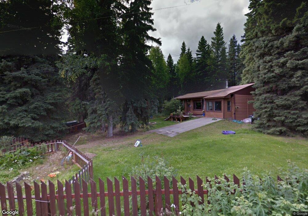
1337 Collins St Fairbanks, AK 99709
Goldstream NeighborhoodEstimated Value: $87,000 - $237,000
--
Bed
1
Bath
1,854
Sq Ft
$91/Sq Ft
Est. Value
About This Home
This home is located at 1337 Collins St, Fairbanks, AK 99709 and is currently estimated at $169,608, approximately $91 per square foot. 1337 Collins St is a home located in Fairbanks North Star Borough with nearby schools including Pearl Creek Elementary School, Randy Smith Middle School, and West Valley High School.
Ownership History
Date
Name
Owned For
Owner Type
Purchase Details
Closed on
Jul 23, 2001
Sold by
Lee Douglas E and Lee Rebecca
Bought by
Russell Gabrielle
Current Estimated Value
Home Financials for this Owner
Home Financials are based on the most recent Mortgage that was taken out on this home.
Original Mortgage
$106,215
Outstanding Balance
$41,141
Interest Rate
7.21%
Estimated Equity
$128,467
Create a Home Valuation Report for This Property
The Home Valuation Report is an in-depth analysis detailing your home's value as well as a comparison with similar homes in the area
Home Values in the Area
Average Home Value in this Area
Purchase History
| Date | Buyer | Sale Price | Title Company |
|---|---|---|---|
| Russell Gabrielle | -- | Yukon Title Company Inc |
Source: Public Records
Mortgage History
| Date | Status | Borrower | Loan Amount |
|---|---|---|---|
| Open | Russell Gabrielle | $106,215 |
Source: Public Records
Tax History Compared to Growth
Tax History
| Year | Tax Paid | Tax Assessment Tax Assessment Total Assessment is a certain percentage of the fair market value that is determined by local assessors to be the total taxable value of land and additions on the property. | Land | Improvement |
|---|---|---|---|---|
| 2025 | $2,283 | $194,010 | $13,071 | $180,939 |
| 2024 | $2,092 | $182,479 | $13,071 | $169,408 |
| 2023 | $2,039 | $179,813 | $13,071 | $166,742 |
| 2022 | $2,016 | $164,471 | $13,071 | $151,400 |
| 2021 | $1,830 | $143,332 | $13,071 | $130,261 |
| 2020 | $1,812 | $141,501 | $13,071 | $128,430 |
| 2019 | $1,906 | $147,362 | $13,071 | $134,291 |
| 2018 | $1,751 | $145,517 | $13,071 | $132,446 |
| 2017 | $1,990 | $141,328 | $13,071 | $128,257 |
| 2016 | $2,148 | $136,943 | $13,071 | $123,872 |
| 2015 | $2,029 | $134,751 | $13,071 | $121,680 |
| 2014 | $2,029 | $131,521 | $13,071 | $118,450 |
Source: Public Records
Map
Nearby Homes
- 2360 Lichen Way
- 2310 Franklin St
- 1269 Helios Ave
- 2330 Stevens Ave
- 2231 Sunshine Ave
- 1170 Propwash Dr
- 2832 Opal Ave
- L12 B2 Obsidian Ct
- NHN Obsidian Ct
- 1385 Coyote Trail
- 641 Miller Hill Rd
- 0 Pine Wood Rd
- 1900 Pandora Dr
- 959 Reindeer Dr
- 1901 Kittiwake Dr
- 1904 Bucks Dr
- 1793 Iniakuk Ave Unit Cabin A&B
- 1788 Army Rd
- 561 Nature Trail Unit 567, 547, 549 Nature
- 128 Alpenglow Ln
- 1349 Collins St
- 1329 Collins St
- 2471 Nugget Loop
- 1344 Collins St
- 2368 Goldstream Rd
- 2383 Nugget Loop
- 2451 Nugget Loop Unit 2459 Nugget Loop
- 2451 Nugget Loop
- 2425 Nugget Loop
- 2369 Nugget Loop
- 2495 Nugget Loop
- 1347 Sargents Cir
- 1361 Sargents Cir
- 2386 Nugget Loop
- 2351 Nugget Loop
- 1366 Sargents Cir
- 2436 Nugget Loop
- 2376 Nugget Loop
- 2410 Nugget Loop
- 2343 Nugget Loop