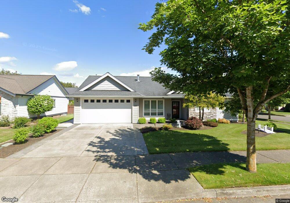
1337 Pearl Loop Lynden, WA 98264
Estimated Value: $550,000 - $625,000
3
Beds
2
Baths
1,561
Sq Ft
$374/Sq Ft
Est. Value
About This Home
This home is located at 1337 Pearl Loop, Lynden, WA 98264 and is currently estimated at $583,131, approximately $373 per square foot. 1337 Pearl Loop is a home with nearby schools including Lynden High School, Lynden Christian School, and Lynden Christian Schools: Administration.
Ownership History
Date
Name
Owned For
Owner Type
Purchase Details
Closed on
Mar 25, 2011
Sold by
Howard Mary Ann
Bought by
Howard Brenton Ian
Current Estimated Value
Purchase Details
Closed on
Mar 24, 2011
Sold by
Duke Development Corporation
Bought by
Howard Brenton Ian
Create a Home Valuation Report for This Property
The Home Valuation Report is an in-depth analysis detailing your home's value as well as a comparison with similar homes in the area
Home Values in the Area
Average Home Value in this Area
Purchase History
| Date | Buyer | Sale Price | Title Company |
|---|---|---|---|
| Howard Brenton Ian | -- | Chicago Title Insurance | |
| Howard Brenton Ian | $255,280 | Chicago Title Insurance |
Source: Public Records
Tax History Compared to Growth
Tax History
| Year | Tax Paid | Tax Assessment Tax Assessment Total Assessment is a certain percentage of the fair market value that is determined by local assessors to be the total taxable value of land and additions on the property. | Land | Improvement |
|---|---|---|---|---|
| 2024 | $3,806 | $535,347 | $218,250 | $317,097 |
| 2023 | $3,806 | $529,901 | $225,000 | $304,901 |
| 2022 | $3,554 | $466,786 | $126,357 | $340,429 |
| 2021 | $3,486 | $385,769 | $104,426 | $281,343 |
| 2020 | $3,053 | $344,446 | $93,240 | $251,206 |
| 2019 | $2,716 | $315,882 | $85,610 | $230,272 |
| 2018 | $2,969 | $288,098 | $77,987 | $210,111 |
| 2017 | $2,710 | $258,593 | $70,000 | $188,593 |
| 2016 | $2,553 | $251,066 | $63,800 | $187,266 |
| 2015 | $2,263 | $235,272 | $61,364 | $173,908 |
| 2014 | -- | $227,303 | $59,276 | $168,027 |
| 2013 | -- | $226,027 | $58,000 | $168,027 |
Source: Public Records
Map
Nearby Homes
- 107 Springview Dr
- 137 E Cedar Dr
- 8780 Depot Rd Unit 207
- 8780 Depot Rd Unit 308
- 8780 Depot Rd Unit 309
- 600 Sunrise Dr
- 301 S Park St
- 300 Homestead Blvd Unit 104
- 114 Twin Sister Loop
- 761 Sunrise Dr
- 8639 Bender Rd
- 9586 Bender Rd
- 805 Cedar Dr
- 8872 Depot Rd Unit 203
- 735 Ivy St
- 872 Sunrise Dr
- 885 Sunrise Dr
- 1739 Emerald Way
- 0 Island Green Way
- 424 Island Green Way
- 1321 Pearl Loop
- 18 Pearl Lp
- 14 Pearl Lp
- 17 Pearl Lp
- 15 Pearl Lp
- 16 Pearl Lp
- 1361 Pearl Loop
- 1377 Pearl Loop
- 1342 Pearl Loop
- 1318 Pearl Loop Unit A&B
- 1318 Pearl Loop Unit 1 & 2
- 1318 Pearl Loop Unit 2
- 1318 Pearl Loop Unit 1
- 1318 Pearl Loop
- 1334 Pearl Loop
- 1305 Pearl Loop
- 1310 Pearl Loop Unit A&B
- 1310 Pearl Loop
- 1350 Pearl Loop
- 1393 Pearl Loop