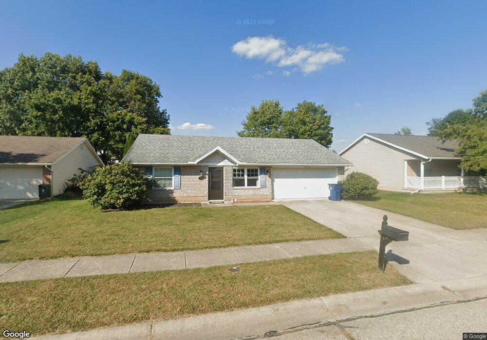
1338 Buckthorn Ct Springfield, OH 45502
Estimated Value: $225,477 - $293,000
3
Beds
2
Baths
1,296
Sq Ft
$201/Sq Ft
Est. Value
About This Home
This home is located at 1338 Buckthorn Ct, Springfield, OH 45502 and is currently estimated at $260,619, approximately $201 per square foot. 1338 Buckthorn Ct is a home located in Clark County with nearby schools including Northridge Elementary School, Kenton Ridge Middle & High School, and Emmanuel Christian Academy.
Ownership History
Date
Name
Owned For
Owner Type
Purchase Details
Closed on
Oct 31, 2016
Sold by
Powell James T and Powell Melissa J
Bought by
Wallace Emmett
Current Estimated Value
Home Financials for this Owner
Home Financials are based on the most recent Mortgage that was taken out on this home.
Original Mortgage
$126,262
Outstanding Balance
$100,547
Interest Rate
3.42%
Mortgage Type
Future Advance Clause Open End Mortgage
Estimated Equity
$160,072
Create a Home Valuation Report for This Property
The Home Valuation Report is an in-depth analysis detailing your home's value as well as a comparison with similar homes in the area
Home Values in the Area
Average Home Value in this Area
Purchase History
| Date | Buyer | Sale Price | Title Company |
|---|---|---|---|
| Wallace Emmett | $125,000 | Springdale Title Llc |
Source: Public Records
Mortgage History
| Date | Status | Borrower | Loan Amount |
|---|---|---|---|
| Open | Wallace Emmett | $126,262 |
Source: Public Records
Tax History
| Year | Tax Paid | Tax Assessment Tax Assessment Total Assessment is a certain percentage of the fair market value that is determined by local assessors to be the total taxable value of land and additions on the property. | Land | Improvement |
|---|---|---|---|---|
| 2025 | $2,334 | $76,150 | $12,210 | $63,940 |
| 2024 | $2,257 | $53,380 | $10,820 | $42,560 |
| 2023 | $2,257 | $53,380 | $10,820 | $42,560 |
| 2022 | $2,266 | $53,380 | $10,820 | $42,560 |
| 2021 | $2,167 | $43,270 | $8,390 | $34,880 |
| 2020 | $2,169 | $43,270 | $8,390 | $34,880 |
| 2019 | $2,210 | $43,270 | $8,390 | $34,880 |
| 2018 | $2,189 | $41,140 | $8,720 | $32,420 |
| 2017 | $1,876 | $43,642 | $8,719 | $34,923 |
| 2016 | $1,467 | $43,642 | $8,719 | $34,923 |
| 2015 | $871 | $39,855 | $8,386 | $31,469 |
| 2014 | $885 | $39,855 | $8,386 | $31,469 |
| 2013 | $1,253 | $39,855 | $8,386 | $31,469 |
Source: Public Records
Map
Nearby Homes
- 5722 Victorian Way Unit 31
- 5564 Ridgewood Rd W
- 1325 Northfield Ct
- 5564 Ridgewood Rd E Unit 7
- 937 Willow Rd
- Pendleton Plan at
- Holcombe Plan at
- Newcastle Plan at
- Chatham Plan at
- 1470 Oldham Dr Unit 12
- 1707 Berwick Dr
- 1836 Dunseth Ln
- 1709 Thomas Dr
- 4741 Cullen Ave
- 1033 Westmont Cir
- 4652 Reno Ln Unit 15
- 862 Brendle Trace Unit 20
- 4446 Ridgewood Rd E Unit 3
- 4343 Burchill St
- 593 Hiser Ave
- 1336 Buckthorn Ct
- 1340 Buckthorn Ct
- 1334 Buckthorn Ct
- 1337 Westview Ave
- 1333 Westview Ave
- 1341 Westview Ave
- 1337 Buckthorn Ct
- 1329 Westview Ave
- 1335 Buckthorn Ct
- 1339 Buckthorn Ct
- 1332 Buckthorn Ct
- 1333 Buckthorn Ct
- 1325 Westview Ave
- 5714 Ridgewood Rd W
- 1330 Buckthorn Ct
- 5744 Ridgewood Rd W
- 5744 W Ridgewood Rd
- 5698 Ridgewood Rd W
- 1331 Buckthorn Ct
- 5684 Ridgewood Rd W
Your Personal Tour Guide
Ask me questions while you tour the home.