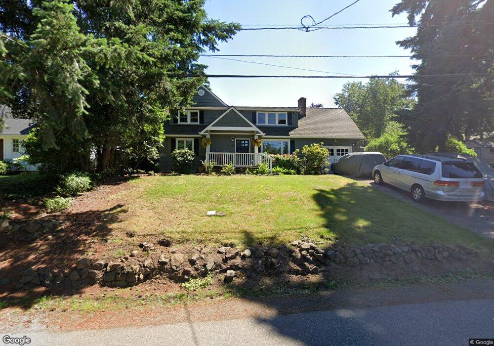
1338 Laurel St Lake Oswego, OR 97034
McVey-South Shore NeighborhoodEstimated Value: $802,164 - $985,000
3
Beds
3
Baths
2,212
Sq Ft
$407/Sq Ft
Est. Value
About This Home
This home is located at 1338 Laurel St, Lake Oswego, OR 97034 and is currently estimated at $901,291, approximately $407 per square foot. 1338 Laurel St is a home located in Clackamas County with nearby schools including Hallinan Elementary School, Lakeridge Middle School, and Lakeridge High School.
Ownership History
Date
Name
Owned For
Owner Type
Purchase Details
Closed on
Aug 22, 2008
Sold by
Schmidt Matthew M and Schmidt Roxanne L
Bought by
Foster John S and Foster Diana J
Current Estimated Value
Home Financials for this Owner
Home Financials are based on the most recent Mortgage that was taken out on this home.
Original Mortgage
$230,000
Outstanding Balance
$149,877
Interest Rate
6.27%
Mortgage Type
Purchase Money Mortgage
Estimated Equity
$751,414
Purchase Details
Closed on
Feb 11, 1999
Sold by
Harrell Benjamin T and Harrell Diana B
Bought by
Schmidt Matthew M and Schmidt Roxanne L
Home Financials for this Owner
Home Financials are based on the most recent Mortgage that was taken out on this home.
Original Mortgage
$180,000
Interest Rate
6.77%
Create a Home Valuation Report for This Property
The Home Valuation Report is an in-depth analysis detailing your home's value as well as a comparison with similar homes in the area
Home Values in the Area
Average Home Value in this Area
Purchase History
| Date | Buyer | Sale Price | Title Company |
|---|---|---|---|
| Foster John S | $530,000 | Fidelity Natl Title Co Of Or | |
| Schmidt Matthew M | $192,000 | First American Title Co |
Source: Public Records
Mortgage History
| Date | Status | Borrower | Loan Amount |
|---|---|---|---|
| Open | Foster John S | $230,000 | |
| Previous Owner | Schmidt Matthew M | $180,000 |
Source: Public Records
Tax History Compared to Growth
Tax History
| Year | Tax Paid | Tax Assessment Tax Assessment Total Assessment is a certain percentage of the fair market value that is determined by local assessors to be the total taxable value of land and additions on the property. | Land | Improvement |
|---|---|---|---|---|
| 2025 | $5,421 | $282,902 | -- | -- |
| 2024 | $5,277 | $274,663 | -- | -- |
| 2023 | $5,277 | $266,664 | $0 | $0 |
| 2022 | $4,970 | $258,898 | $0 | $0 |
| 2021 | $4,589 | $251,358 | $0 | $0 |
| 2020 | $4,474 | $244,037 | $0 | $0 |
| 2019 | $4,364 | $236,930 | $0 | $0 |
| 2018 | $4,150 | $230,029 | $0 | $0 |
| 2017 | $4,004 | $223,329 | $0 | $0 |
| 2016 | $3,645 | $216,824 | $0 | $0 |
| 2015 | $3,521 | $210,509 | $0 | $0 |
| 2014 | $3,476 | $204,378 | $0 | $0 |
Source: Public Records
Map
Nearby Homes
- 1247 Spruce St
- 1225 Spruce St
- 1206 Cedar St
- 1130 Laurel St
- 1710 S Shore Blvd
- 1535 Larch St
- 16081 Pearcy St
- 719 SW Maple St
- 1725 Southshore Blvd
- 1527 Lake Front Rd
- 1720 Kilkenny Dr
- 1865 Palisades Lake Ct
- 1060 Upper Devon Ln
- 1674 Fircrest Dr
- 1640 Meadows Dr
- 630 Ridgeway Rd
- 1872 Palisades Terrace Dr
- 600 Maple St
- 589 Ridgeway Rd
- 919 Westpoint Rd