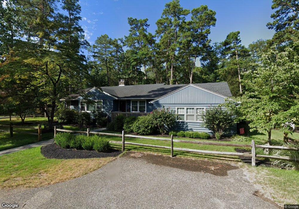
134 Apache Trail Medford, NJ 08055
Estimated Value: $487,655 - $673,000
Studio
--
Bath
2,080
Sq Ft
$266/Sq Ft
Est. Value
About This Home
This home is located at 134 Apache Trail, Medford, NJ 08055 and is currently estimated at $553,164, approximately $265 per square foot. 134 Apache Trail is a home located in Burlington County with nearby schools including Nokomis School, Neeta School, and Shawnee High School.
Ownership History
Date
Name
Owned For
Owner Type
Purchase Details
Closed on
Jul 28, 1998
Sold by
Saraceni William H and Saraceni Nancie A
Bought by
Snyder John G and Snyder Gail
Current Estimated Value
Home Financials for this Owner
Home Financials are based on the most recent Mortgage that was taken out on this home.
Original Mortgage
$129,650
Outstanding Balance
$27,047
Interest Rate
6.92%
Estimated Equity
$526,117
Create a Home Valuation Report for This Property
The Home Valuation Report is an in-depth analysis detailing your home's value as well as a comparison with similar homes in the area
Home Values in the Area
Average Home Value in this Area
Purchase History
| Date | Buyer | Sale Price | Title Company |
|---|---|---|---|
| Snyder John G | $136,500 | Fidelity National Title |
Source: Public Records
Mortgage History
| Date | Status | Borrower | Loan Amount |
|---|---|---|---|
| Open | Snyder John G | $129,650 |
Source: Public Records
Tax History
| Year | Tax Paid | Tax Assessment Tax Assessment Total Assessment is a certain percentage of the fair market value that is determined by local assessors to be the total taxable value of land and additions on the property. | Land | Improvement |
|---|---|---|---|---|
| 2025 | $10,068 | $264,800 | $87,200 | $177,600 |
| 2024 | $9,520 | $264,800 | $87,200 | $177,600 |
| 2023 | $9,520 | $264,800 | $87,200 | $177,600 |
| 2022 | $9,313 | $264,800 | $87,200 | $177,600 |
| 2021 | $8,817 | $264,800 | $87,200 | $177,600 |
| 2020 | $8,818 | $264,800 | $87,200 | $177,600 |
| 2019 | $8,802 | $264,800 | $87,200 | $177,600 |
| 2018 | $8,580 | $264,800 | $87,200 | $177,600 |
| 2017 | $7,943 | $264,800 | $87,200 | $177,600 |
| 2016 | $7,739 | $264,800 | $87,200 | $177,600 |
| 2015 | $7,689 | $264,800 | $87,200 | $177,600 |
| 2014 | $7,503 | $264,800 | $87,200 | $177,600 |
Source: Public Records
Map
Nearby Homes
- 23 Lenape Trail
- 65 Cutchogue Trail
- 105 Algonquin Trail
- Lot 8.03 Sunrise Trail
- 19 Big Look Trail
- 98 Nantucket Trail
- 187 S Lakeside Dr E
- 55 Wrentham Dr Unit 69
- 179 Chickahominy Trail
- 178 Nahma Trail
- 155 Tuckerton Rd
- 167 Winooska Trail
- 0 Tuckerton and Atsion Rd
- 30 Brattleboro Ct Unit 30
- 3 S Lakeside Dr W
- 11 Hawthorne Dr
- 0 Jackson Rd Unit NJBL2085060
- 18 Tomahawk Ct
- 13 Running Water Ct
- 27 Little John Dr
- 128 Apache Trail
- 131 Navajo Trail
- 127 Navajo Trail
- 28 Pawnee Trail
- 125 Navajo Trail
- 129 Apache Trail
- 124 Apache Trail
- 125 Apache Trail
- 121 Navajo Trail
- 133 Apache Trail
- 123 Apache Trail
- 132 Navajo Trail
- 138 Apache Trail
- 120 Apache Trail
- 117 Apache Trail
- 137 Navajo Trail
- 128 Stokes Rd
- 137 Apache Trail
- 27 Mohawk Trail
- 17 Mohawk Trail
Your Personal Tour Guide
Ask me questions while you tour the home.