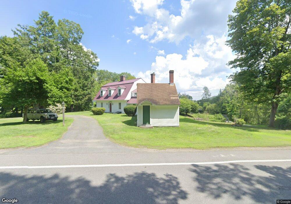
134 Ashfield Mountain Rd Ashfield, MA 01330
Ashfield NeighborhoodEstimated Value: $516,000 - $594,000
5
Beds
4
Baths
2,795
Sq Ft
$202/Sq Ft
Est. Value
About This Home
This home is located at 134 Ashfield Mountain Rd, Ashfield, MA 01330 and is currently estimated at $564,169, approximately $201 per square foot. 134 Ashfield Mountain Rd is a home located in Franklin County with nearby schools including Mohawk Trail Regional High School.
Ownership History
Date
Name
Owned For
Owner Type
Purchase Details
Closed on
May 20, 2015
Sold by
Pepyne Carol J and Pepyne David L
Bought by
Condon Kenneth A and White Caroline S
Current Estimated Value
Purchase Details
Closed on
May 16, 2007
Sold by
Pepyne Carol J and Pepyne Edward W
Bought by
Pepyne Carol J and Pepyne David L
Create a Home Valuation Report for This Property
The Home Valuation Report is an in-depth analysis detailing your home's value as well as a comparison with similar homes in the area
Home Values in the Area
Average Home Value in this Area
Purchase History
We collect this data history from publicly available records. To have your information removed, we recommend requesting removal directly through your county’s website.
| Date | Buyer | Sale Price | Title Company |
|---|---|---|---|
| Condon Kenneth A | $3,000 | -- | |
| Pepyne Carol J | -- | -- |
Source: Public Records
Tax History
| Year | Tax Paid | Tax Assessment Tax Assessment Total Assessment is a certain percentage of the fair market value that is determined by local assessors to be the total taxable value of land and additions on the property. | Land | Improvement |
|---|---|---|---|---|
| 2025 | $6,785 | $504,100 | $205,300 | $298,800 |
| 2024 | $7,118 | $487,200 | $205,300 | $281,900 |
| 2023 | $6,595 | $374,500 | $165,100 | $209,400 |
| 2022 | $6,196 | $356,500 | $157,300 | $199,200 |
| 2021 | $5,788 | $349,700 | $157,300 | $192,400 |
| 2020 | $5,826 | $349,700 | $157,300 | $192,400 |
| 2019 | $5,689 | $331,500 | $150,200 | $181,300 |
| 2018 | $5,637 | $328,100 | $150,200 | $177,900 |
| 2017 | $5,289 | $326,100 | $148,200 | $177,900 |
| 2016 | $5,138 | $312,500 | $148,200 | $164,300 |
| 2015 | $4,992 | $312,600 | $148,300 | $164,300 |
| 2014 | -- | $307,800 | $139,300 | $168,500 |
Source: Public Records
Map
Nearby Homes
- 14 South St
- 0 N Bear River Rd Unit 73485981
- 0 Sears Rd Unit 73373850
- 333 Ranney Corner Rd
- 3 Hog Hollow Rd
- 311 Cummington Rd
- 1230 Main Poland Rd
- 54 E Main St
- 2930 Shelburne Falls Rd
- 78 Shaw Rd
- 278 E Main St
- 11 Bray Rd
- 0 Maple St
- 2 Franklin St
- 10 Deerfield Ave Unit 2
- 0, Lot 7 East Rd
- Lot 3.2 East Rd
- 143 Charlemont Rd
- 58 River Rd
- 44 Aberdeen Rd
- 176A Ashfield Mountain Rd
- 30 Smith Rd
- 126C Ashfield Mountain Rd
- 126A Ashfield Mountain Rd
- 126B Ashfield Mountain Rd
- 176B Ashfield Mountain Rd
- 197 Ashfield Mountain Rd
- 385 Buckland Rd
- 267 Buckland Rd
- 325 Buckland Rd
- 305 Buckland Rd
- 335 Buckland Rd
- 249 Buckland Rd
- 0 Buckland Rd (Rt 112) Unit 30073002
- 0 Ashfield Mountain Rd Unit 70531733
- 0 Ashfield Mountain Rd Unit 70621730
- 286 Buckland Rd
- 280 Buckland Rd
- 294 Buckland Rd
- 268 Buckland Rd
Your Personal Tour Guide
Ask me questions while you tour the home.