R
Seller's Agent in 2024
Ryan Gregor
Fathom Realty WA LLC
(360) 710-2112
49 Total Sales


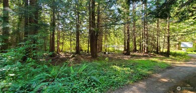
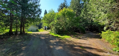


This parcel is 2.01 acres and is ready with a 3 bedroom septic system, a Well, 25'x 36' garage, 12' x 23' shop area, solar panels, a concrete slab to possibly build on and is fully fenced. The property is near Port Townsend International Airport if you fly and at the beginning of Milo Curry Rd is the Larry Scott Memorial Trail Head. The property is flat and ready for a new home.
Last Agent to Sell the Property
Fathom Realty WA LLC License #77674 Listed on: 07/19/2024

Source: Northwest Multiple Listing Service (NWMLS)
MLS#: 2267116
| Date | Type | Sale Price | Title Company |
|---|---|---|---|
| Warranty Deed | -- | Horizon Title Group | |
| Warranty Deed | -- | Horizon Title Group |
| Date | Event | Price | List to Sale | Price per Sq Ft |
|---|---|---|---|---|
| 12/02/2024 12/02/24 | Sold | $185,300 | -11.7% | -- |
| 10/30/2024 10/30/24 | Pending | -- | -- | -- |
| 10/22/2024 10/22/24 | Price Changed | $209,900 | -8.7% | -- |
| 10/03/2024 10/03/24 | Price Changed | $229,900 | -8.0% | -- |
| 09/07/2024 09/07/24 | Price Changed | $249,900 | -7.4% | -- |
| 08/14/2024 08/14/24 | Price Changed | $269,900 | -6.6% | -- |
| 07/19/2024 07/19/24 | For Sale | $289,000 | -- | -- |
| Year | Tax Paid | Tax Assessment Tax Assessment Total Assessment is a certain percentage of the fair market value that is determined by local assessors to be the total taxable value of land and additions on the property. | Land | Improvement |
|---|---|---|---|---|
| 2024 | $789 | $83,817 | $67,106 | $16,711 |
| 2023 | $789 | $79,614 | $63,630 | $15,984 |
| 2022 | $657 | $74,524 | $59,993 | $14,531 |
| 2021 | $658 | $59,164 | $48,156 | $11,008 |
| 2020 | $643 | $56,497 | $45,968 | $10,529 |
| 2019 | $593 | $53,829 | $43,778 | $10,051 |
| 2018 | $682 | $53,350 | $43,778 | $9,572 |
| 2017 | $461 | $55,032 | $45,334 | $9,698 |
| 2016 | $435 | $148,143 | $43,362 | $104,781 |
| 2015 | $674 | $143,587 | $43,362 | $100,225 |
| 2014 | -- | $143,587 | $43,362 | $100,225 |
| 2013 | -- | $130,535 | $39,420 | $91,115 |
R
Seller's Agent in 2024
Ryan Gregor
Fathom Realty WA LLC
(360) 710-2112
49 Total Sales
Source: Northwest Multiple Listing Service (NWMLS)
MLS Number: 2267116
APN: 001321054
Disclaimer: Certain information contained herein is derived from information provided by parties other than Homes.com. All information provided is deemed reliable, but is not guaranteed to be accurate and should be independently verified.
![]() All data is obtained from various sources and may not have been verified by broker or MLS GRID. Supplied Open House Information is subject to change without notice. All information should be independently reviewed and verified for accuracy. Properties may or may not be listed by the office/agent presenting the information. Listing information is provided by the Northwest Multiple Listing Service (NWMLS). Property information is based on available data that may include MLS information, county records, and other sources. Listings marked with the 3 tree icon and provided by NWMLS. All properties are subject to prior sale or withdrawal. IDX information is provided exclusively for consumers’ personal noncommercial use, that it may not be used for any purpose other than to identify prospective properties consumers may be interested in purchasing, that the data is deemed reliable but is not guaranteed by MLS GRID. ©2025 NWMLS.
All data is obtained from various sources and may not have been verified by broker or MLS GRID. Supplied Open House Information is subject to change without notice. All information should be independently reviewed and verified for accuracy. Properties may or may not be listed by the office/agent presenting the information. Listing information is provided by the Northwest Multiple Listing Service (NWMLS). Property information is based on available data that may include MLS information, county records, and other sources. Listings marked with the 3 tree icon and provided by NWMLS. All properties are subject to prior sale or withdrawal. IDX information is provided exclusively for consumers’ personal noncommercial use, that it may not be used for any purpose other than to identify prospective properties consumers may be interested in purchasing, that the data is deemed reliable but is not guaranteed by MLS GRID. ©2025 NWMLS.
Based on information submitted to the MLS GRID