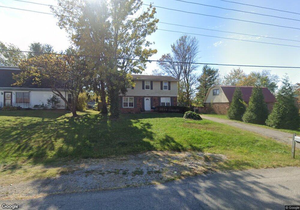
134 E Showalter Dr Georgetown, KY 40324
Mount Vernon NeighborhoodEstimated Value: $237,000 - $297,000
4
Beds
2
Baths
1,536
Sq Ft
$170/Sq Ft
Est. Value
About This Home
This home is located at 134 E Showalter Dr, Georgetown, KY 40324 and is currently estimated at $261,208, approximately $170 per square foot. 134 E Showalter Dr is a home located in Scott County with nearby schools including Southern Elementary School, Georgetown Middle School, and Scott County High School.
Ownership History
Date
Name
Owned For
Owner Type
Purchase Details
Closed on
Jan 21, 2020
Sold by
Aron Mcclain and Aron Jennifer Mcclain
Bought by
Mcclain Properties Georgetown Llc
Current Estimated Value
Purchase Details
Closed on
Dec 21, 2011
Sold by
Federal Home Loan Mortgage Corporation
Bought by
Mcclain Aron
Purchase Details
Closed on
Oct 11, 2011
Sold by
Sparks Delilah and Sparks Donnie D
Bought by
Federal Home Loan Mortgage Corp
Create a Home Valuation Report for This Property
The Home Valuation Report is an in-depth analysis detailing your home's value as well as a comparison with similar homes in the area
Home Values in the Area
Average Home Value in this Area
Purchase History
| Date | Buyer | Sale Price | Title Company |
|---|---|---|---|
| Mcclain Properties Georgetown Llc | -- | None Available | |
| Mcclain Aron | $70,000 | None Available | |
| Federal Home Loan Mortgage Corp | $66,334 | None Available |
Source: Public Records
Tax History
| Year | Tax Paid | Tax Assessment Tax Assessment Total Assessment is a certain percentage of the fair market value that is determined by local assessors to be the total taxable value of land and additions on the property. | Land | Improvement |
|---|---|---|---|---|
| 2025 | $1,793 | $201,300 | $0 | $0 |
| 2024 | $1,710 | $190,200 | $0 | $0 |
| 2023 | $1,655 | $182,500 | $32,000 | $150,500 |
| 2022 | $1,388 | $163,200 | $25,000 | $138,200 |
| 2021 | $1,411 | $149,800 | $25,000 | $124,800 |
| 2020 | $1,192 | $138,700 | $25,000 | $113,700 |
| 2019 | $1,156 | $132,500 | $0 | $0 |
| 2018 | $1,037 | $119,464 | $0 | $0 |
| 2017 | $1,042 | $119,464 | $0 | $0 |
| 2016 | $919 | $114,088 | $0 | $0 |
| 2015 | $876 | $109,500 | $0 | $0 |
| 2014 | $908 | $109,500 | $0 | $0 |
| 2011 | $70 | $112,552 | $0 | $0 |
Source: Public Records
Map
Nearby Homes
- 139 E Showalter Dr
- 305 Yorktown Ct
- 1336 Dorchester Dr
- 104 Bronte Place
- 107 Oconner Ct
- 1117 Pawnee Trail
- 1026 Parkside Dr
- 206 Hiawatha Trail
- 633 Military St
- 199 Hawthorne Dr
- 106 Ransom Trace
- 115 Victor Place
- 207 Berkshire Ln
- 103 Crescent Way
- 101 Crescent Way
- 113 Walden Cove Unit 3I
- 129 Compass Trail
- 107 Crescent Way
- 124 Compass Trail
- 128 Compass Trail
- 132 E Showalter Dr
- 136 E Showalter Dr
- 130 E Showalter Dr
- 105 Potomac Ct
- 103 Potomac Ct
- 1301 Fairfax Way
- 107 Potomac Ct
- 135 E Showalter Dr
- 133 E Showalter Dr
- 128 E Showalter Dr
- 137 E Showalter Dr
- 101 Potomac Ct
- 109 Potomac Ct
- 131 E Showalter Dr
- 129 E Showalter Dr
- 126 E Showalter Dr
- 1300 Fairfax Way
- 111 Potomac Ct
- 127 E Showalter Dr
- 201 Potomac Dr
Your Personal Tour Guide
Ask me questions while you tour the home.