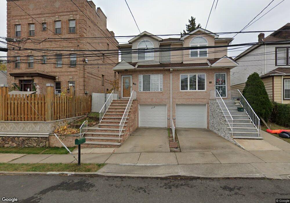
134 Lyman Ave Unit 136 Staten Island, NY 10305
Fort Wadsworth NeighborhoodEstimated Value: $670,200 - $826,000
3
Beds
3
Baths
784
Sq Ft
$967/Sq Ft
Est. Value
About This Home
This home is located at 134 Lyman Ave Unit 136, Staten Island, NY 10305 and is currently estimated at $758,300, approximately $967 per square foot. 134 Lyman Ave Unit 136 is a home located in Richmond County with nearby schools including Ps 13 M L Lindenmeyer, I.S. 49 Berta A Dreyfus, and Curtis High School.
Ownership History
Date
Name
Owned For
Owner Type
Purchase Details
Closed on
Jul 15, 2009
Sold by
Franco Elizabeth and Elizabeth Franco Revocable Tru
Bought by
Guven Idris and Guven Leyla
Current Estimated Value
Home Financials for this Owner
Home Financials are based on the most recent Mortgage that was taken out on this home.
Original Mortgage
$342,400
Interest Rate
5.21%
Mortgage Type
New Conventional
Purchase Details
Closed on
Feb 5, 2005
Sold by
Franco Elizabeth
Bought by
Franco Elizabeth and The Elizabeth Franco Revocable
Purchase Details
Closed on
Jul 16, 1998
Sold by
Block 3730 Corp
Bought by
Franco Elizabeth
Home Financials for this Owner
Home Financials are based on the most recent Mortgage that was taken out on this home.
Original Mortgage
$176,490
Interest Rate
6.8%
Create a Home Valuation Report for This Property
The Home Valuation Report is an in-depth analysis detailing your home's value as well as a comparison with similar homes in the area
Home Values in the Area
Average Home Value in this Area
Purchase History
| Date | Buyer | Sale Price | Title Company |
|---|---|---|---|
| Guven Idris | $428,000 | None Available | |
| Franco Elizabeth | -- | -- | |
| Franco Elizabeth | $196,500 | -- |
Source: Public Records
Mortgage History
| Date | Status | Borrower | Loan Amount |
|---|---|---|---|
| Previous Owner | Guven Idris | $342,400 | |
| Previous Owner | Franco Elizabeth | $176,490 |
Source: Public Records
Tax History Compared to Growth
Tax History
| Year | Tax Paid | Tax Assessment Tax Assessment Total Assessment is a certain percentage of the fair market value that is determined by local assessors to be the total taxable value of land and additions on the property. | Land | Improvement |
|---|---|---|---|---|
| 2025 | $3,440 | $41,520 | $5,241 | $36,279 |
| 2024 | $3,452 | $39,600 | $5,184 | $34,416 |
| 2023 | $3,479 | $25,920 | $5,256 | $20,664 |
| 2022 | $3,377 | $39,000 | $7,920 | $31,080 |
| 2021 | $3,283 | $41,100 | $7,920 | $33,180 |
| 2020 | $3,050 | $38,580 | $7,920 | $30,660 |
| 2019 | $2,770 | $33,540 | $7,920 | $25,620 |
| 2018 | $2,687 | $21,600 | $4,924 | $16,676 |
| 2017 | $3,431 | $21,437 | $5,763 | $15,674 |
| 2016 | $3,135 | $20,224 | $6,511 | $13,713 |
| 2015 | $2,650 | $19,080 | $5,830 | $13,250 |
| 2014 | $2,650 | $18,000 | $6,600 | $11,400 |
Source: Public Records
Map
Nearby Homes
- 136 Lyman Ave Unit 5
- 105 Fingerboard Rd
- 25 Summer St Unit 52
- 18 Brown Place
- 20 Brown Place
- 47 High St
- 68 Hope Ln
- 39 Bang Terrace
- 7 Egbert Place
- 91 Narrows Rd N Unit C
- 33 Hope Ave
- 291 Hillbrook Dr
- 50 Belair Rd Unit 1A
- 50 Belair Rd Unit 4I
- 50 Belair Rd Unit 1E
- 50 Belair Rd Unit 5E
- 42 Narrows Rd S Unit 277
- 85 Dogwood Ln
- 135 Saint Johns Ave
- 43 Belair Rd